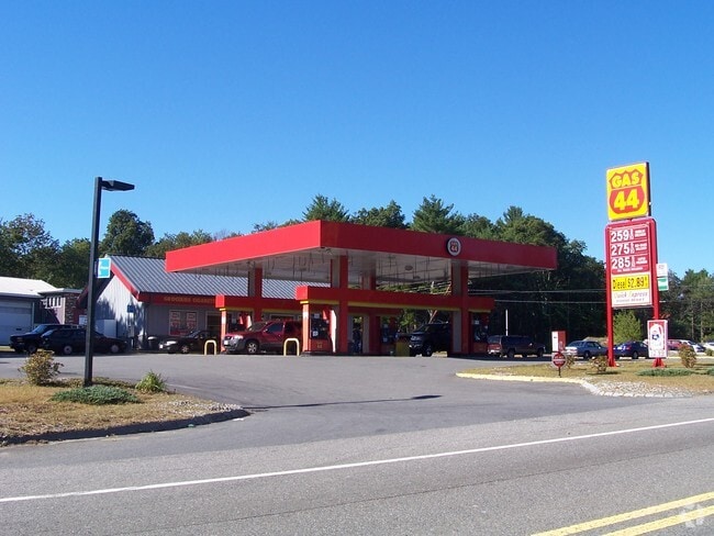
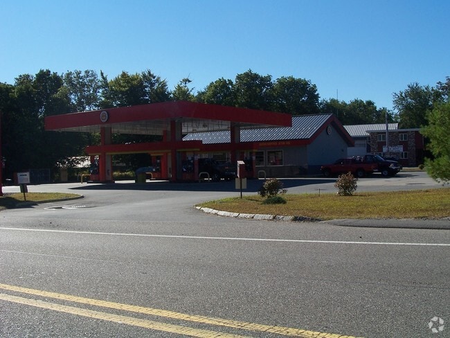
Property Record
1375 New State Hwy, Raynham, MA 02767


Save to a Folder
{{folder.Name}}
{{folder.ListingIds.length}} Properties
{{folder.ListingIds.length}} Property
Create a New Folder
Property Detail
1375 New State Hwy
RAYN-000015-000160
Bristol
Servicestation
Massachusetts
B and X Area of moderate flood hazard, usually the area between the limits of the 100-year and 500-year floods.
1.28 AC
2025
Attleboro/New Bedford
2025
Boston
612202
Providence-Warwick, RI-MA
2,100 SF
NEARBY LISTINGS FOR SALE OR LEASE
DEMOGRAPHICS near 1375 New State Hwy
1 mile
3 mile
5 mile
2025 Total Population
2,539
20,874
74,462
2030 Population
2,635
21,408
75,882
Pop Growth 2025-2030
+ 3.78%
+ 2.56%
+ 1.91%
Average Age
43
42
41
2025 Total Households
928
7,689
28,578
HH Growth 2025-2030
+ 3.99%
+ 2.61%
+ 1.91%
Median Household Inc
$127,083
$113,573
$85,186
Avg Household Size
2.70
2.70
2.50
2025 Avg HH Vehicles
2.00
2.00
2.00
Median Home Value
$601,731
$488,731
$481,788
Median Year Built
1993
1984
1973
Nearby Places
Map Layers
Map Styles
 Street
 Aerial
Layers
 Traffic
 Biking
Places
Listings with unknown addresses are not visible on the map
- Restaurants
- Banks
- Shops
- Fitness
- Groceries
PUBLIC TRANSPORTATION
COMMUTER RAIL
Middleborough/Lakeville (Middleborough/Lakeville Line - Massachusetts Bay Transportation Authority Commuter Rail (Purple Line))
Drive
Walk
Distance
Middleborough/Lakeville (Middleborough/Lakeville Line - Massachusetts Bay Transportation Authority Commuter Rail (Purple Line))
10 min
5.8 mi
AIRPORT
Rhode Island Tf Green International
Drive
Walk
Distance
Rhode Island Tf Green International
51 min
29.5 mi
General Edward Lawrence Logan International
Drive
Walk
Distance
General Edward Lawrence Logan International
52 min
38.7 mi
Freight Ports
Port of New Bedford Harbor
Drive
Walk
Distance
Port of New Bedford Harbor
33 min
24.5 mi
Nearby Properties
Address
Land Use
TOTAL SIZE
Lot Size
Zoning
Address
Land Use
TOTAL SIZE
Lot Size
Zoning
850,008 SF
172.89 AC
INDUST
Address
Land Use
TOTAL SIZE
Lot Size
Zoning
133,652 SF
2 AC
Address
Land Use
TOTAL SIZE
Lot Size
Zoning
815,324 SF
88.80 AC
Address
Land Use
TOTAL SIZE
Lot Size
Zoning
Address
Land Use
TOTAL SIZE
Lot Size
Zoning
158,638 SF
54.12 AC
Address
Land Use
TOTAL SIZE
Lot Size
Zoning
117,752 SF
22.37 AC
Address
Land Use
TOTAL SIZE
Lot Size
Zoning
217,011 SF
73.55 AC
OPSPAC
Address
Land Use
TOTAL SIZE
Lot Size
Zoning
27 AC
INDUST
Address
Land Use
TOTAL SIZE
Lot Size
Zoning
136,122 SF
49.49 AC
Address
Land Use
TOTAL SIZE
Lot Size
Zoning
67,588 SF
18.81 AC
SUBRES
Address
Land Use
TOTAL SIZE
Lot Size
Zoning
178.18 AC
OPSPAC
Address
Land Use
TOTAL SIZE
Lot Size
Zoning
14.43 AC
Address
Land Use
TOTAL SIZE
Lot Size
Zoning
137,710 SF
26.66 AC
Address
Land Use
TOTAL SIZE
Lot Size
Zoning
10,680 SF
79.73 AC
Address
Land Use
TOTAL SIZE
Lot Size
Zoning
206,139 SF
21.55 AC
Address
Land Use
TOTAL SIZE
Lot Size
Zoning
257,810 SF
20.62 AC
Address
Land Use
TOTAL SIZE
Lot Size
Zoning
16 AC
URBRES
Address
Land Use
TOTAL SIZE
Lot Size
Zoning
1,783 SF
9.29 AC
Address
Land Use
TOTAL SIZE
Lot Size
Zoning
107,794 SF
12.51 AC
Address
Land Use
TOTAL SIZE
Lot Size
Zoning
133,773 SF
24.50 AC
Address
Land Use
TOTAL SIZE
Lot Size
Zoning
58,937 SF
5.49 AC
Address
Land Use
TOTAL SIZE
Lot Size
Zoning
16.06 AC
Address
Land Use
TOTAL SIZE
Lot Size
Zoning
76,111 SF
14.50 AC
Address
Land Use
TOTAL SIZE
Lot Size
Zoning
69,153 SF
4.47 AC
Address
Land Use
TOTAL SIZE
Lot Size
Zoning
112,770 SF
17.98 AC
Address
Land Use
TOTAL SIZE
Lot Size
Zoning
149,089 SF
22.71 AC
Address
Land Use
TOTAL SIZE
Lot Size
Zoning
51,664 SF
3.44 AC
Address
Land Use
TOTAL SIZE
Lot Size
Zoning
42,133 SF
17.68 AC
Address
Land Use
TOTAL SIZE
Lot Size
Zoning
33,696 SF
11.09 AC
INDUST
Address
Land Use
TOTAL SIZE
Lot Size
Zoning
34,800 SF
3.53 AC
The World's #1 Commercial Real Estate Marketplace
Connect with us
© 2026 CoStar Group
The information above has been obtained from sources believed reliable. While we do not doubt its accuracy we have not verified it and make no guarantee, warranty or representation about it. It is your responsibility to independently confirm its accuracy and completeness. Any projections, opinions, assumptions, or estimates used are for example only and do not represent the current or future performance of the property. The value of this transaction to you depends on tax and other factors which should be evaluated by your tax, financial, and legal advisors. You and your advisors should conduct a careful, independent investigation of the property to determine to your satisfaction the suitability of the property for your needs.