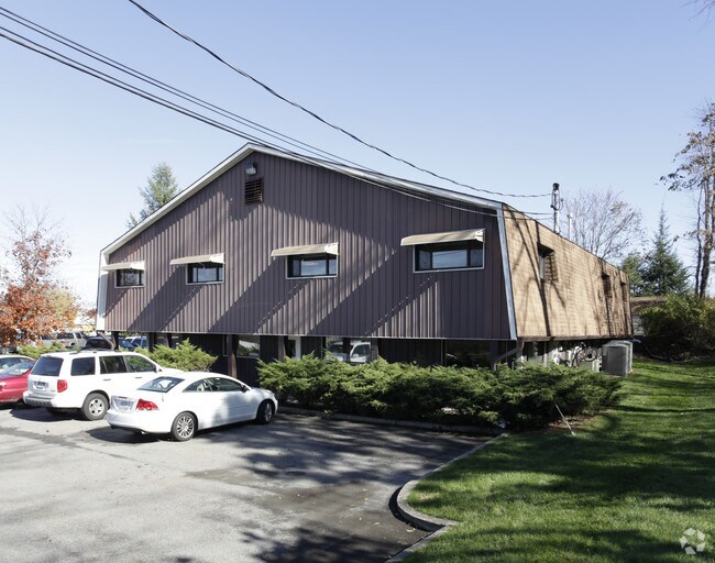
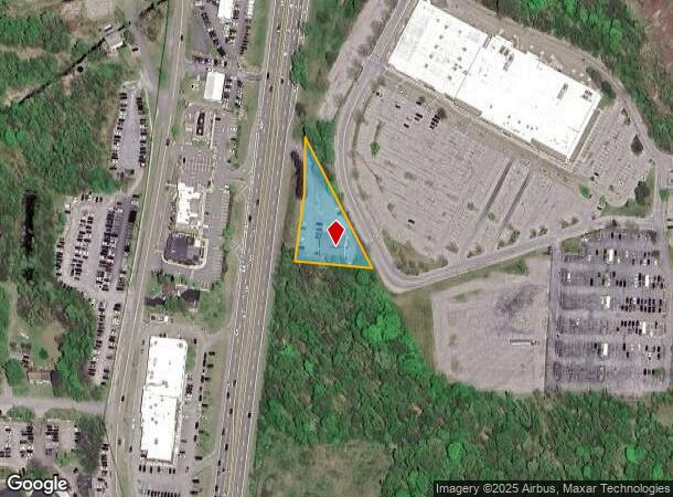
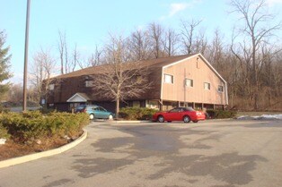
Property Record
1376 Route 9, Wappingers Falls, NY 12590
NEARBY LISTINGS FOR SALE OR LEASE
Property Detail
1376 Route 9
135689-6157-02-626677-0000
0.75 AC (C) 1704 0297 1186 0105
Officebuilding
Dutchess
X
New York
36027C0458E
626
2025
0.75 AC
2024
Fishkill
190204
Westchester/So Connecticut
11,880 SF
Dutchess County-Putnam County, NY
DEMOGRAPHICS near 1376 Route 9
1 Mile
3 Mile
5 Mile
2024 Total Population
6,183
30,615
75,146
2029 Population
6,167
30,550
74,991
Pop Growth 2024-2029
(0.26%)
(0.21%)
(0.21%)
Average Age
43
43
43
2024 Total Households
2,624
12,042
28,960
HH Growth 2024-2029
(0.34%)
(0.24%)
(0.23%)
Median Household Inc
$78,920
$91,452
$97,129
Avg Household Size
2.30
2.50
2.50
2024 Avg HH Vehicles
2.00
2.00
2.00
Median Home Value
$336,214
$344,760
$354,764
Median Year Built
1971
1968
1972
Nearby Places
- Restaurants
- Banks
- Shops
- Fitness
- Groceries
PUBLIC TRANSPORTATION
COMMUTER RAIL
New Hamburg Station (Hudson Line - Metro-North Commuter Railroad Company (Metro-North))
DRIVE
WALK
Distance
New Hamburg Station (Hudson Line - Metro-North Commuter Railroad Company (Metro-North))
7 min
2.9 mi
Beacon Station (Hudson Line - Metro-North Commuter Railroad Company (Metro-North))
DRIVE
WALK
Distance
Beacon Station (Hudson Line - Metro-North Commuter Railroad Company (Metro-North))
15 min
9.3 mi
AIRPORT
New York Stewart International
DRIVE
WALK
Distance
New York Stewart International
29 min
17.8 mi
Freight Ports
Port of New Haven
DRIVE
WALK
Distance
Port of New Haven
98 min
71.8 mi
Nearby Properties
Address
Land Use
TOTAL SIZE
Lot Size
Zoning
Address
Land Use
TOTAL SIZE
Lot Size
Zoning
11.76 AC
R4A
Address
Land Use
TOTAL SIZE
Lot Size
Zoning
293,984 SF
47.95 AC
RMF5
Address
Land Use
TOTAL SIZE
Lot Size
Zoning
197,820 SF
56.20 AC
R20
Address
Land Use
TOTAL SIZE
Lot Size
Zoning
535,543 SF
72.62 AC
BSC
Address
Land Use
TOTAL SIZE
Lot Size
Zoning
143,274 SF
31.04 AC
R20/40
Address
Land Use
TOTAL SIZE
Lot Size
Zoning
104,800 SF
17.20 AC
R20
Address
Land Use
TOTAL SIZE
Lot Size
Zoning
21,996 SF
17.36 AC
RMF5
Address
Land Use
TOTAL SIZE
Lot Size
Zoning
123,536 SF
18.10 AC
GB
Address
Land Use
TOTAL SIZE
Lot Size
Zoning
151,698 SF
22.50 AC
PI
Address
Land Use
TOTAL SIZE
Lot Size
Zoning
32,920 SF
21.55 AC
CB-30
Address
Land Use
TOTAL SIZE
Lot Size
Zoning
211,760 SF
86.81 AC
SC
Address
Land Use
TOTAL SIZE
Lot Size
Zoning
40,030 SF
4.50 AC
HB
Address
Land Use
TOTAL SIZE
Lot Size
Zoning
98,700 SF
10 AC
BSC
Address
Land Use
TOTAL SIZE
Lot Size
Zoning
106,025 SF
7.20 AC
RM2
Address
Land Use
TOTAL SIZE
Lot Size
Zoning
160,214 SF
17.47 AC
R20
Address
Land Use
TOTAL SIZE
Lot Size
Zoning
328,878 SF
30.82 AC
PI
Address
Land Use
TOTAL SIZE
Lot Size
Zoning
100 SF
5.70 AC
IN
Address
Land Use
TOTAL SIZE
Lot Size
Zoning
192,321 SF
12.98 AC
SC
Address
Land Use
TOTAL SIZE
Lot Size
Zoning
Address
Land Use
TOTAL SIZE
Lot Size
Zoning
103,422 SF
9.16 AC
CB-30
Address
Land Use
TOTAL SIZE
Lot Size
Zoning
128,806 SF
11.93 AC
BSC
Address
Land Use
TOTAL SIZE
Lot Size
Zoning
35 AC
R40
Address
Land Use
TOTAL SIZE
Lot Size
Zoning
54,326 SF
12.82 AC
HB
Address
Land Use
TOTAL SIZE
Lot Size
Zoning
95,648 SF
8.59 AC
CB-32
Address
Land Use
TOTAL SIZE
Lot Size
Zoning
42,052 SF
4.64 AC
BH
Address
Land Use
TOTAL SIZE
Lot Size
Zoning
93,440 SF
9.99 AC
BSC
Address
Land Use
TOTAL SIZE
Lot Size
Zoning
28,117 SF
5 AC
HB
Address
Land Use
TOTAL SIZE
Lot Size
Zoning
116,592 SF
3.40 AC
RM5
Address
Land Use
TOTAL SIZE
Lot Size
Zoning
116,592 SF
3.60 AC
RM2
Address
Land Use
TOTAL SIZE
Lot Size
Zoning
22 AC
R40
The World's #1 Commercial Real Estate Marketplace
Connect with us
© 2025 CoStar Group
The information above has been obtained from sources believed reliable. While we do not doubt its accuracy we have not verified it and make no guarantee, warranty or representation about it. It is your responsibility to independently confirm its accuracy and completeness. Any projections, opinions, assumptions, or estimates used are for example only and do not represent the current or future performance of the property. The value of this transaction to you depends on tax and other factors which should be evaluated by your tax, financial, and legal advisors. You and your advisors should conduct a careful, independent investigation of the property to determine to your satisfaction the suitability of the property for your needs.