Property Record
13760 Old Saint Augustine Rd, Jacksonville, FL 32258

NEARBY LISTINGS FOR SALE OR LEASE
Property Detail
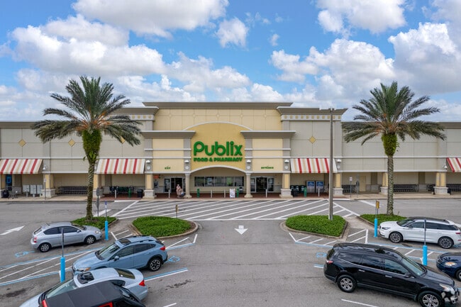
13760 Old Saint Augustine Rd
158767-2820
Shoppes At Bartram Park
Regionalshoppingcenterormallwithanchorstore
57-56 24-4S-27E 4.59 SHOPPES AT BARTRAM PARK REPLAT PARCEL G-2
X
Duval
12031C0568J
Florida
2024
4.60 AC
2025
Mandarin
016812
Jacksonville (Florida)
33,014 SF
Jacksonville, FL
DEMOGRAPHICS near 13760 Old Saint Augustine Rd
1 Mile
3 Mile
5 Mile
2024 Total Population
4,599
51,242
131,743
2029 Population
4,792
56,868
149,740
Pop Growth 2024-2029
+ 4.20%
+ 10.98%
+ 13.66%
Average Age
38
38
39
2024 Total Households
2,036
19,488
49,619
HH Growth 2024-2029
+ 4.32%
+ 9.94%
+ 12.15%
Median Household Inc
$95,433
$95,848
$96,642
Avg Household Size
2.20
2.60
2.60
2024 Avg HH Vehicles
2.00
2.00
2.00
Median Home Value
$237,154
$311,334
$338,573
Median Year Built
2004
2006
2001
Nearby Places
Map Layers
Map Styles
 Street
 Aerial
- Restaurants
- Banks
- Shops
- Fitness
- Groceries
PUBLIC TRANSPORTATION
AIRPORT
Jacksonville International
DRIVE
WALK
Distance
Jacksonville International
45 min
31.6 mi
Freight Ports
Jacksonville Port
DRIVE
WALK
Distance
Jacksonville Port
29 min
20.1 mi
SALE & LEASE HISTORY
LISTING DATE
SALE/LEASE

Sep 25, 2016
For Lease
Jun 15, 2017
For Lease
Nearby Properties
Address
Land Use
TOTAL SIZE
Lot Size
Zoning
Address
Land Use
TOTAL SIZE
Lot Size
Zoning
879,352 SF
31.37 AC
PUD
Address
Land Use
TOTAL SIZE
Lot Size
Zoning
534,591 SF
39.81 AC
PUD
Address
Land Use
TOTAL SIZE
Lot Size
Zoning
810,921 SF
58.85 AC
PUD
Address
Land Use
TOTAL SIZE
Lot Size
Zoning
470,627 SF
21.61 AC
PUD
Address
Land Use
TOTAL SIZE
Lot Size
Zoning
450,888 SF
27.01 AC
PUD
Address
Land Use
TOTAL SIZE
Lot Size
Zoning
345,678 SF
30.40 AC
PUD
Address
Land Use
TOTAL SIZE
Lot Size
Zoning
381,269 SF
25.73 AC
PUD
Address
Land Use
TOTAL SIZE
Lot Size
Zoning
243,751 SF
15.29 AC
PUD
Address
Land Use
TOTAL SIZE
Lot Size
Zoning
340,852 SF
19.65 AC
PUD
Address
Land Use
TOTAL SIZE
Lot Size
Zoning
311,304 SF
18.93 AC
PUD
Address
Land Use
TOTAL SIZE
Lot Size
Zoning
215,194 SF
58.34 AC
PUD
Address
Land Use
TOTAL SIZE
Lot Size
Zoning
298,018 SF
15.53 AC
PUD
Address
Land Use
TOTAL SIZE
Lot Size
Zoning
371,039 SF
20.63 AC
Address
Land Use
TOTAL SIZE
Lot Size
Zoning
427,236 SF
72.23 AC
PUD
Address
Land Use
TOTAL SIZE
Lot Size
Zoning
271,074 SF
17.77 AC
CCG-1
Address
Land Use
TOTAL SIZE
Lot Size
Zoning
276,262 SF
10.01 AC
PUD
Address
Land Use
TOTAL SIZE
Lot Size
Zoning
264,962 SF
11.24 AC
PUD
Address
Land Use
TOTAL SIZE
Lot Size
Zoning
262,043 SF
10.89 AC
PUD
Address
Land Use
TOTAL SIZE
Lot Size
Zoning
356,254 SF
22.04 AC
PUD
Address
Land Use
TOTAL SIZE
Lot Size
Zoning
162,943 SF
7.36 AC
PUD
Address
Land Use
TOTAL SIZE
Lot Size
Zoning
119,560 SF
22.05 AC
PUD
Address
Land Use
TOTAL SIZE
Lot Size
Zoning
225,730 SF
42.22 AC
PBF-2
Address
Land Use
TOTAL SIZE
Lot Size
Zoning
360,341 SF
22.37 AC
PUD
Address
Land Use
TOTAL SIZE
Lot Size
Zoning
167,195 SF
7.56 AC
PUD
Address
Land Use
TOTAL SIZE
Lot Size
Zoning
330,139 SF
73.17 AC
PBF-1
Address
Land Use
TOTAL SIZE
Lot Size
Zoning
173,502 SF
16.18 AC
PUD
Address
Land Use
TOTAL SIZE
Lot Size
Zoning
99,267 SF
10.89 AC
PUD
Address
Land Use
TOTAL SIZE
Lot Size
Zoning
99,725 SF
8.40 AC
PUD
Address
Land Use
TOTAL SIZE
Lot Size
Zoning
224,180 SF
18.48 AC
PUD
Address
Land Use
TOTAL SIZE
Lot Size
Zoning
59,660 SF
11.10 AC
PUD
The World's #1 Commercial Real Estate Marketplace
Connect with us
© 2025 CoStar Group
The information above has been obtained from sources believed reliable. While we do not doubt its accuracy we have not verified it and make no guarantee, warranty or representation about it. It is your responsibility to independently confirm its accuracy and completeness. Any projections, opinions, assumptions, or estimates used are for example only and do not represent the current or future performance of the property. The value of this transaction to you depends on tax and other factors which should be evaluated by your tax, financial, and legal advisors. You and your advisors should conduct a careful, independent investigation of the property to determine to your satisfaction the suitability of the property for your needs.