Property Record
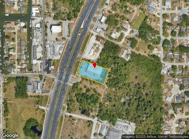
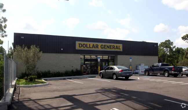
13780 Us Highway 19, Hudson, FL 34667

NEARBY LISTINGS FOR SALE OR LEASE
Property Detail
13780 Us Highway 19
Tampa-St. Petersburg-Clearwater, FL
Gulf View Terrace
34-24-16-0010-00200-0060
GULF VIEW TERR NO 1 PB 4 PG 111 ALL OF LOTS 6 15 & 16 & PORTION OF LOTS 14 17 & 5 BLK 2 DESC AS: COM AT MOST ELY COR OF LOT 10, BLK 2 TH N66DEG 5400W 320.00 FT TO MOST NLY COR OF LOT 9 BLK 2 TH ALG ARC CV L RAD 5629.65 FT CHD BRG & DIST S21DEG 1900W
Storebuilding
Pasco
AE
Florida
12101C0177G
6
2024
1.26 AC
2025
Pasco County
031101
Tampa/St Petersburg
12,552 SF
DEMOGRAPHICS near 13780 Us Highway 19
1 Mile
3 Mile
5 Mile
2024 Total Population
7,528
44,355
86,202
2029 Population
9,164
53,404
103,578
Pop Growth 2024-2029
+ 21.73%
+ 20.40%
+ 20.16%
Average Age
53
50
47
2024 Total Households
3,690
20,619
37,859
HH Growth 2024-2029
+ 21.79%
+ 20.48%
+ 20.19%
Median Household Inc
$46,949
$43,327
$43,972
Avg Household Size
2.00
2.10
2.20
2024 Avg HH Vehicles
1.00
1.00
2.00
Median Home Value
$208,971
$156,978
$151,175
Median Year Built
1980
1980
1979
Nearby Places
Map Layers
Map Styles
 Street
 Aerial
- Restaurants
- Banks
- Shops
- Fitness
- Groceries
PUBLIC TRANSPORTATION
AIRPORT
Tampa International
DRIVE
WALK
Distance
Tampa International
58 min
40.8 mi
Freight Ports
Port of Tampa Bay
DRIVE
WALK
Distance
Port of Tampa Bay
71 min
44.4 mi
Nearby Properties
Address
Land Use
TOTAL SIZE
Lot Size
Zoning
Address
Land Use
TOTAL SIZE
Lot Size
Zoning
250,601 SF
38.64 AC
C2
Address
Land Use
TOTAL SIZE
Lot Size
Zoning
414,111 SF
23.78 AC
C1
Address
Land Use
TOTAL SIZE
Lot Size
Zoning
124,316 SF
22.91 AC
MF1
Address
Land Use
TOTAL SIZE
Lot Size
Zoning
124,470 SF
5.09 AC
C2
Address
Land Use
TOTAL SIZE
Lot Size
Zoning
189,166 SF
18.19 AC
C2
Address
Land Use
TOTAL SIZE
Lot Size
Zoning
106,741 SF
27.67 AC
MF1
Address
Land Use
TOTAL SIZE
Lot Size
Zoning
217,758 SF
34.95 AC
C2
Address
Land Use
TOTAL SIZE
Lot Size
Zoning
190,794 SF
10.88 AC
C2
Address
Land Use
TOTAL SIZE
Lot Size
Zoning
111,060 SF
9.31 AC
C3
Address
Land Use
TOTAL SIZE
Lot Size
Zoning
75,205 SF
12.71 AC
PUD
Address
Land Use
TOTAL SIZE
Lot Size
Zoning
81,839 SF
3.33 AC
C2
Address
Land Use
TOTAL SIZE
Lot Size
Zoning
48,470 SF
4.19 AC
MPUD
Address
Land Use
TOTAL SIZE
Lot Size
Zoning
90,113 SF
8.22 AC
C2
Address
Land Use
TOTAL SIZE
Lot Size
Zoning
83,363 SF
5.97 AC
C2
Address
Land Use
TOTAL SIZE
Lot Size
Zoning
38,187 SF
6.48 AC
MPUD
Address
Land Use
TOTAL SIZE
Lot Size
Zoning
80,025 SF
10.55 AC
MF2
Address
Land Use
TOTAL SIZE
Lot Size
Zoning
52,704 SF
5 AC
MF2
Address
Land Use
TOTAL SIZE
Lot Size
Zoning
171,441 SF
8.70 AC
MF2
Address
Land Use
TOTAL SIZE
Lot Size
Zoning
59,228 SF
3.43 AC
PUD
Address
Land Use
TOTAL SIZE
Lot Size
Zoning
188,871 SF
8.44 AC
C1
Address
Land Use
TOTAL SIZE
Lot Size
Zoning
49,118 SF
7.72 AC
C2
Address
Land Use
TOTAL SIZE
Lot Size
Zoning
83,135 SF
4.49 AC
MF2
Address
Land Use
TOTAL SIZE
Lot Size
Zoning
48,098 SF
2.52 AC
C2
Address
Land Use
TOTAL SIZE
Lot Size
Zoning
41,120 SF
2.47 AC
PUD
Address
Land Use
TOTAL SIZE
Lot Size
Zoning
41,120 SF
1.51 AC
PUD
Address
Land Use
TOTAL SIZE
Lot Size
Zoning
94,431 SF
10.79 AC
C2
Address
Land Use
TOTAL SIZE
Lot Size
Zoning
29,752 SF
12.61 AC
C2
Address
Land Use
TOTAL SIZE
Lot Size
Zoning
224,941 SF
23.03 AC
C2
Address
Land Use
TOTAL SIZE
Lot Size
Zoning
35,992 SF
9.83 AC
C2
Address
Land Use
TOTAL SIZE
Lot Size
Zoning
53,406 SF
9.11 AC
C2
The World's #1 Commercial Real Estate Marketplace
Connect with us
© 2025 CoStar Group
The information above has been obtained from sources believed reliable. While we do not doubt its accuracy we have not verified it and make no guarantee, warranty or representation about it. It is your responsibility to independently confirm its accuracy and completeness. Any projections, opinions, assumptions, or estimates used are for example only and do not represent the current or future performance of the property. The value of this transaction to you depends on tax and other factors which should be evaluated by your tax, financial, and legal advisors. You and your advisors should conduct a careful, independent investigation of the property to determine to your satisfaction the suitability of the property for your needs.