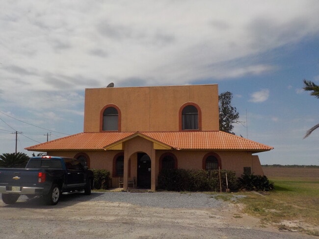
Property Record
Fm 3067, Santa Maria, TX 78592
Current Lease Availabilities
NEARBY LISTINGS FOR SALE OR LEASE
-
-
View all Santa Maria listings for lease on LoopNet.com
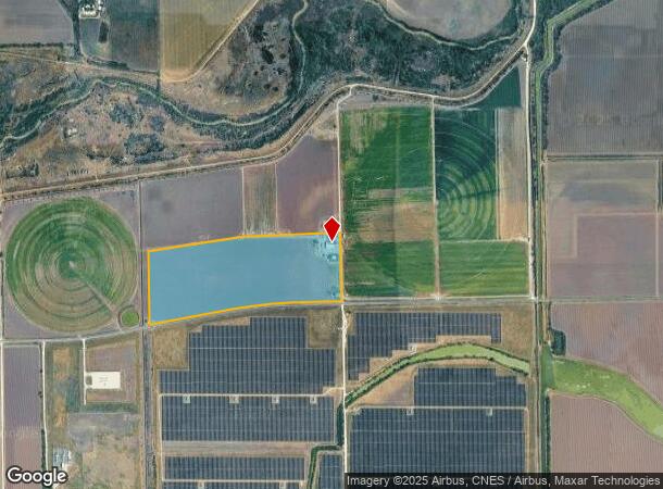
Property Detail
Fm 3067
Brownsville/Harlingen
La Gloria Canal Co Subdivision
Brownsville-Harlingen, TX
Cameron
853290-0080-001000
Texas
Ruralagriculturalresidence
22.38 AC
8,465 SF
Outlying Cameron County
DEMOGRAPHICS near Fm 3067
1 Mile
3 Mile
5 Mile
2024 Total Population
13
5,043
23,742
2029 Population
13
5,064
24,484
Pop Growth 2024-2029
0.00%
+ 0.42%
+ 3.13%
Average Age
35
38
38
2024 Total Households
4
1,651
7,889
HH Growth 2024-2029
0.00%
+ 0.42%
+ 3.40%
Median Household Inc
$67,500
$40,068
$50,129
Avg Household Size
3.70
3.00
2.90
2024 Avg HH Vehicles
1.00
2.00
2.00
Median Home Value
$50,000
$91,918
$109,710
Median Year Built
1994
1987
1990
Nearby Places
- Restaurants
- Banks
- Shops
- Fitness
- Groceries
PUBLIC TRANSPORTATION
AIRPORT
Valley International
DRIVE
WALK
Distance
Valley International
24 min
15.5 mi
McAllen International
DRIVE
WALK
Distance
McAllen International
43 min
32.7 mi
Brownsville/South Padre Island International
DRIVE
WALK
Distance
Brownsville/South Padre Island International
46 min
33.9 mi
Freight Ports
Port of Brownsville
DRIVE
WALK
Distance
Port of Brownsville
39 min
31.5 mi
Nearby Properties
Address
Land Use
TOTAL SIZE
Lot Size
Zoning
Address
Land Use
TOTAL SIZE
Lot Size
Zoning
58,495 SF
24.73 AC
Address
Land Use
TOTAL SIZE
Lot Size
Zoning
40,364 SF
2.66 AC
B
Address
Land Use
TOTAL SIZE
Lot Size
Zoning
1,040 SF
4.96 AC
C
Address
Land Use
TOTAL SIZE
Lot Size
Zoning
17,160 SF
0.64 AC
A-C
Address
Land Use
TOTAL SIZE
Lot Size
Zoning
23,040 SF
1.60 AC
Address
Land Use
TOTAL SIZE
Lot Size
Zoning
23,040 SF
1.98 AC
Address
Land Use
TOTAL SIZE
Lot Size
Zoning
19,019 SF
0.69 AC
C
Address
Land Use
TOTAL SIZE
Lot Size
Zoning
9,482 SF
1.51 AC
C
Address
Land Use
TOTAL SIZE
Lot Size
Zoning
3.86 AC
C
Address
Land Use
TOTAL SIZE
Lot Size
Zoning
3.86 AC
C
Address
Land Use
TOTAL SIZE
Lot Size
Zoning
26,231 SF
3 AC
B
Address
Land Use
TOTAL SIZE
Lot Size
Zoning
8,816 SF
1.03 AC
B
Address
Land Use
TOTAL SIZE
Lot Size
Zoning
11,781 SF
1.32 AC
C
Address
Land Use
TOTAL SIZE
Lot Size
Zoning
8,515 SF
0.43 AC
C
Address
Land Use
TOTAL SIZE
Lot Size
Zoning
25,843 SF
3.74 AC
B
Address
Land Use
TOTAL SIZE
Lot Size
Zoning
9,901 SF
1.32 AC
Address
Land Use
TOTAL SIZE
Lot Size
Zoning
7,417 SF
0.80 AC
C
Address
Land Use
TOTAL SIZE
Lot Size
Zoning
9,912 SF
4.78 AC
Address
Land Use
TOTAL SIZE
Lot Size
Zoning
7,456 SF
1.06 AC
C
Address
Land Use
TOTAL SIZE
Lot Size
Zoning
11,339 SF
0.89 AC
Address
Land Use
TOTAL SIZE
Lot Size
Zoning
8,192 SF
0.60 AC
C
Address
Land Use
TOTAL SIZE
Lot Size
Zoning
3,620 SF
0.28 AC
Address
Land Use
TOTAL SIZE
Lot Size
Zoning
5,241 SF
2.15 AC
Address
Land Use
TOTAL SIZE
Lot Size
Zoning
1.93 AC
C
Address
Land Use
TOTAL SIZE
Lot Size
Zoning
10,710 SF
1.32 AC
Address
Land Use
TOTAL SIZE
Lot Size
Zoning
5,050 SF
0.32 AC
A-C
Address
Land Use
TOTAL SIZE
Lot Size
Zoning
4,056 SF
0.33 AC
A-C
Address
Land Use
TOTAL SIZE
Lot Size
Zoning
8,380 SF
175.57 AC
A-R
Address
Land Use
TOTAL SIZE
Lot Size
Zoning
8,280 SF
3.45 AC
Address
Land Use
TOTAL SIZE
Lot Size
Zoning
4,754 SF
0.37 AC
C
The World's #1 Commercial Real Estate Marketplace
Connect with us
© 2025 CoStar Group
The information above has been obtained from sources believed reliable. While we do not doubt its accuracy we have not verified it and make no guarantee, warranty or representation about it. It is your responsibility to independently confirm its accuracy and completeness. Any projections, opinions, assumptions, or estimates used are for example only and do not represent the current or future performance of the property. The value of this transaction to you depends on tax and other factors which should be evaluated by your tax, financial, and legal advisors. You and your advisors should conduct a careful, independent investigation of the property to determine to your satisfaction the suitability of the property for your needs.