Property Record
1379 Route 197, Woodstock, CT 06281

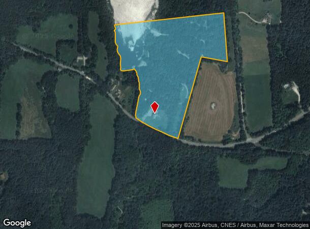
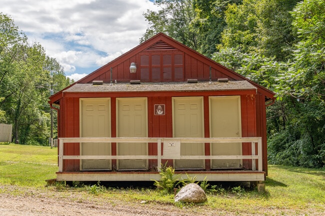
This Property Is For Sale
NEARBY LISTINGS FOR SALE OR LEASE
Property Detail
1379 Route 197
Worcester, MA-CT
Windham
WOOD-005126-000002-000048-000004
Connecticut
Commercialnec
48-4
2024
27 AC
2025
Windham County
901102
Hartford
DEMOGRAPHICS near 1379 Route 197
1 Mile
3 Mile
5 Mile
2024 Total Population
556
3,576
7,332
2029 Population
594
3,819
7,772
Pop Growth 2024-2029
+ 6.83%
+ 6.80%
+ 6.00%
Average Age
44
44
44
2024 Total Households
212
1,376
2,843
HH Growth 2024-2029
+ 7.08%
+ 6.98%
+ 6.19%
Median Household Inc
$111,574
$112,278
$112,455
Avg Household Size
2.60
2.60
2.50
2024 Avg HH Vehicles
3.00
3.00
2.00
Median Home Value
$427,586
$424,953
$421,741
Median Year Built
1984
1983
1982
Nearby Places
- Restaurants
- Banks
- Shops
- Fitness
- Groceries
PUBLIC TRANSPORTATION
AIRPORT
Worcester Regional
DRIVE
WALK
Distance
Worcester Regional
51 min
27.9 mi
Freight Ports
Port of Davisville, RI
DRIVE
WALK
Distance
Port of Davisville, RI
86 min
61.5 mi
Nearby Properties
Address
Land Use
TOTAL SIZE
Lot Size
Zoning
Address
Land Use
TOTAL SIZE
Lot Size
Zoning
42.50 AC
0
Address
Land Use
TOTAL SIZE
Lot Size
Zoning
6.50 AC
Address
Land Use
TOTAL SIZE
Lot Size
Zoning
3,000 SF
2.50 AC
0
Address
Land Use
TOTAL SIZE
Lot Size
Zoning
8.30 AC
0
Address
Land Use
TOTAL SIZE
Lot Size
Zoning
Address
Land Use
TOTAL SIZE
Lot Size
Zoning
22.86 AC
0
Address
Land Use
TOTAL SIZE
Lot Size
Zoning
4,632 SF
10 AC
Address
Land Use
TOTAL SIZE
Lot Size
Zoning
3,820 SF
25 AC
Address
Land Use
TOTAL SIZE
Lot Size
Zoning
3,495 SF
0.81 AC
0
Address
Land Use
TOTAL SIZE
Lot Size
Zoning
Address
Land Use
TOTAL SIZE
Lot Size
Zoning
5.64 AC
0
Address
Land Use
TOTAL SIZE
Lot Size
Zoning
1,720 SF
1.60 AC
0
Address
Land Use
TOTAL SIZE
Lot Size
Zoning
2,298 SF
1.64 AC
0
Address
Land Use
TOTAL SIZE
Lot Size
Zoning
1,565 SF
2.20 AC
0
Address
Land Use
TOTAL SIZE
Lot Size
Zoning
1.70 AC
Address
Land Use
TOTAL SIZE
Lot Size
Zoning
1,613 SF
18.10 AC
0
Address
Land Use
TOTAL SIZE
Lot Size
Zoning
13,520 SF
1 AC
0
Address
Land Use
TOTAL SIZE
Lot Size
Zoning
0.60 AC
0
Address
Land Use
TOTAL SIZE
Lot Size
Zoning
52.80 AC
RR
Address
Land Use
TOTAL SIZE
Lot Size
Zoning
83 AC
Address
Land Use
TOTAL SIZE
Lot Size
Zoning
1,232 SF
1 AC
0
Address
Land Use
TOTAL SIZE
Lot Size
Zoning
Address
Land Use
TOTAL SIZE
Lot Size
Zoning
3,056 SF
1.10 AC
0
Address
Land Use
TOTAL SIZE
Lot Size
Zoning
52.40 AC
Address
Land Use
TOTAL SIZE
Lot Size
Zoning
0.70 AC
Address
Land Use
TOTAL SIZE
Lot Size
Zoning
26.20 AC
Address
Land Use
TOTAL SIZE
Lot Size
Zoning
63.70 AC
Address
Land Use
TOTAL SIZE
Lot Size
Zoning
49.20 AC
Address
Land Use
TOTAL SIZE
Lot Size
Zoning
The World's #1 Commercial Real Estate Marketplace
Connect with us
© 2025 CoStar Group
The information above has been obtained from sources believed reliable. While we do not doubt its accuracy we have not verified it and make no guarantee, warranty or representation about it. It is your responsibility to independently confirm its accuracy and completeness. Any projections, opinions, assumptions, or estimates used are for example only and do not represent the current or future performance of the property. The value of this transaction to you depends on tax and other factors which should be evaluated by your tax, financial, and legal advisors. You and your advisors should conduct a careful, independent investigation of the property to determine to your satisfaction the suitability of the property for your needs.