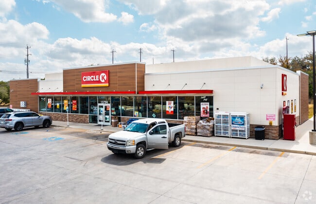
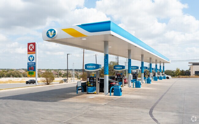
Property Record
13794 Potranco Rd, San Antonio, TX 78253

Save to a Folder
{{folder.Name}}
{{folder.ListingIds.length}} Properties
{{folder.ListingIds.length}} Property
Create a New Folder
Property Detail
13794 Potranco Rd
San Antonio-New Braunfels, TX
CB 4355C (CST #1842), BLOCK 19 LOT 1 2017 NEW ACCT PER PLAT 9707/160-4 FILED 10/28/2016.
04355-319-0010
BEXAR
Servicestation
Texas
B and X Area of moderate flood hazard, usually the area between the limits of the 100-year and 500-year floods.
1
2025
2.01 AC
2025
Far West
172002
San Antonio
42,657 SF
NEARBY LISTINGS FOR SALE OR LEASE
-
-
-
-
-
-
-
No Photo
-
View all San Antonio listings for sale on LoopNet.com
DEMOGRAPHICS near 13794 Potranco Rd
1 mile
3 mile
5 mile
2025 Total Population
6,820
51,501
144,882
2030 Population
7,499
56,152
156,846
Pop Growth 2025-2030
+ 9.96%
+ 9.03%
+ 8.26%
Average Age
33
34
35
2025 Total Households
2,030
15,618
45,016
HH Growth 2025-2030
+ 10.10%
+ 9.37%
+ 8.48%
Median Household Inc
$129,091
$112,141
$101,694
Avg Household Size
3.30
3.20
3.10
2025 Avg HH Vehicles
2.00
2.00
2.00
Median Home Value
$394,563
$350,077
$317,086
Median Year Built
2011
2010
2010
Nearby Places
Map Layers
Map Styles
 Street
 Aerial
Layers
 Traffic
 Biking
Places
Listings with unknown addresses are not visible on the map
- Restaurants
- Banks
- Shops
- Fitness
- Groceries
PUBLIC TRANSPORTATION
AIRPORT
San Antonio International
Drive
Walk
Distance
San Antonio International
31 min
20.4 mi
Nearby Properties
Address
Land Use
TOTAL SIZE
Lot Size
Zoning
Address
Land Use
TOTAL SIZE
Lot Size
Zoning
850,338 SF
93.98 AC
Address
Land Use
TOTAL SIZE
Lot Size
Zoning
333,308 SF
22.04 AC
Address
Land Use
TOTAL SIZE
Lot Size
Zoning
245,000 SF
44.68 AC
Address
Land Use
TOTAL SIZE
Lot Size
Zoning
268,776 SF
10 AC
Address
Land Use
TOTAL SIZE
Lot Size
Zoning
109,685 SF
37.52 AC
Address
Land Use
TOTAL SIZE
Lot Size
Zoning
375,203 SF
15.99 AC
Address
Land Use
TOTAL SIZE
Lot Size
Zoning
332,145 SF
17.03 AC
Address
Land Use
TOTAL SIZE
Lot Size
Zoning
238,098 SF
13.93 AC
Address
Land Use
TOTAL SIZE
Lot Size
Zoning
497,319 SF
60 AC
Address
Land Use
TOTAL SIZE
Lot Size
Zoning
209,459 SF
18.25 AC
Address
Land Use
TOTAL SIZE
Lot Size
Zoning
319,143 SF
30.15 AC
Address
Land Use
TOTAL SIZE
Lot Size
Zoning
228,847 SF
38.28 AC
Address
Land Use
TOTAL SIZE
Lot Size
Zoning
654.58 AC
Address
Land Use
TOTAL SIZE
Lot Size
Zoning
164,025 SF
21.46 AC
Address
Land Use
TOTAL SIZE
Lot Size
Zoning
242.77 AC
Address
Land Use
TOTAL SIZE
Lot Size
Zoning
128,713 SF
15.43 AC
Address
Land Use
TOTAL SIZE
Lot Size
Zoning
409.99 AC
Address
Land Use
TOTAL SIZE
Lot Size
Zoning
442.05 AC
Address
Land Use
TOTAL SIZE
Lot Size
Zoning
324.15 AC
Address
Land Use
TOTAL SIZE
Lot Size
Zoning
152,000 SF
21.83 AC
Address
Land Use
TOTAL SIZE
Lot Size
Zoning
200.84 AC
Address
Land Use
TOTAL SIZE
Lot Size
Zoning
241.16 AC
Address
Land Use
TOTAL SIZE
Lot Size
Zoning
94.43 AC
Address
Land Use
TOTAL SIZE
Lot Size
Zoning
30,800 SF
3.13 AC
Address
Land Use
TOTAL SIZE
Lot Size
Zoning
98,827 SF
3.23 AC
Address
Land Use
TOTAL SIZE
Lot Size
Zoning
92,876 SF
21.64 AC
Address
Land Use
TOTAL SIZE
Lot Size
Zoning
16,486 SF
1.98 AC
Address
Land Use
TOTAL SIZE
Lot Size
Zoning
19,951 SF
2.48 AC
Address
Land Use
TOTAL SIZE
Lot Size
Zoning
97,833 SF
2.69 AC
Address
Land Use
TOTAL SIZE
Lot Size
Zoning
202.74 AC
The World's #1 Commercial Real Estate Marketplace
Connect with us
© 2026 CoStar Group
The information above has been obtained from sources believed reliable. While we do not doubt its accuracy we have not verified it and make no guarantee, warranty or representation about it. It is your responsibility to independently confirm its accuracy and completeness. Any projections, opinions, assumptions, or estimates used are for example only and do not represent the current or future performance of the property. The value of this transaction to you depends on tax and other factors which should be evaluated by your tax, financial, and legal advisors. You and your advisors should conduct a careful, independent investigation of the property to determine to your satisfaction the suitability of the property for your needs.