Property Record
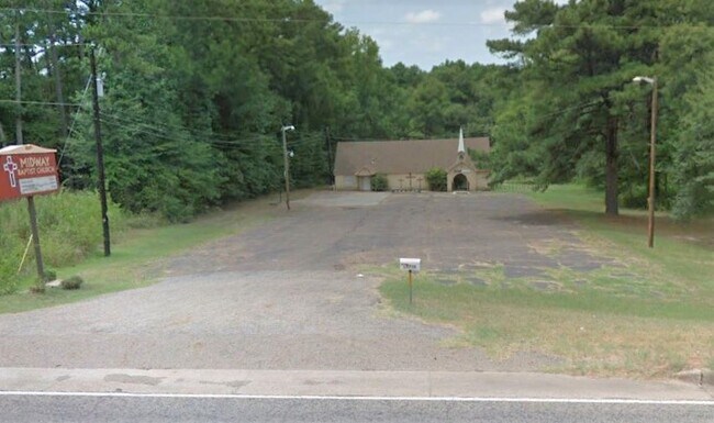
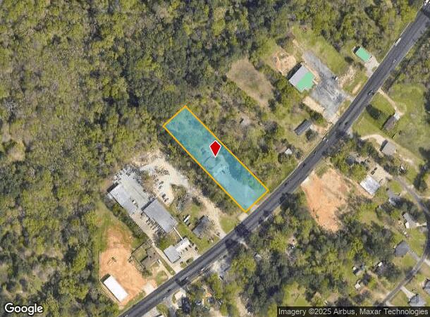
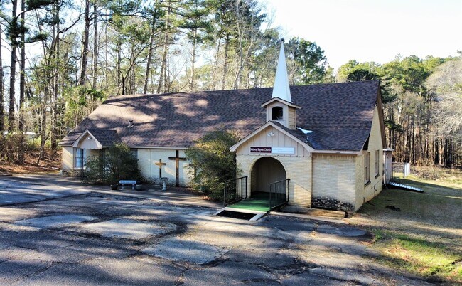
13798 State Highway 155 S, Tyler, TX 75703
NEARBY LISTINGS FOR SALE OR LEASE
Property Detail
13798 State Highway 155 S
1-00000-0018-06-001022
A0018 T Quevado
Religious
ABST A0018 T QUEVADOTRACT 1B
X
Smith
48423C0365D
Texas
0
1.65 AC
2025
Tyler & Longview
001917
Other Market Areas
4,832 SF
Tyler, TX
DEMOGRAPHICS near 13798 State Highway 155 S
1 Mile
3 Mile
5 Mile
2024 Total Population
931
22,755
65,555
2029 Population
1,041
24,832
71,201
Pop Growth 2024-2029
+ 11.82%
+ 9.13%
+ 8.61%
Average Age
43
42
40
2024 Total Households
361
10,008
27,213
HH Growth 2024-2029
+ 11.63%
+ 8.59%
+ 8.05%
Median Household Inc
$65,480
$68,506
$67,668
Avg Household Size
2.40
2.20
2.30
2024 Avg HH Vehicles
2.00
2.00
2.00
Median Home Value
$284,374
$296,010
$245,077
Median Year Built
1991
1999
1987
Nearby Places
Map Layers
Map Styles
 Street
 Aerial
- Restaurants
- Banks
- Shops
- Fitness
- Groceries
PUBLIC TRANSPORTATION
AIRPORT
Tyler Pounds Regional
DRIVE
WALK
Distance
Tyler Pounds Regional
18 min
10.9 mi
Freight Ports
Port of Shreveport
DRIVE
WALK
Distance
Port of Shreveport
129 min
114.5 mi
SALE & LEASE HISTORY
LISTING DATE
SALE/LEASE

Jan 08, 2021
For Sale
Nearby Properties
Address
Land Use
TOTAL SIZE
Lot Size
Zoning
Address
Land Use
TOTAL SIZE
Lot Size
Zoning
11,332 SF
22.07 AC
PMF
Address
Land Use
TOTAL SIZE
Lot Size
Zoning
7,152 SF
19.76 AC
RMF
Address
Land Use
TOTAL SIZE
Lot Size
Zoning
29.58 AC
Address
Land Use
TOTAL SIZE
Lot Size
Zoning
234,762 SF
16.68 AC
Address
Land Use
TOTAL SIZE
Lot Size
Zoning
5,068 SF
18.35 AC
RMF
Address
Land Use
TOTAL SIZE
Lot Size
Zoning
4,333 SF
13.32 AC
Address
Land Use
TOTAL SIZE
Lot Size
Zoning
3,149 SF
16.15 AC
RMF
Address
Land Use
TOTAL SIZE
Lot Size
Zoning
4,349 SF
33.26 AC
RMF
Address
Land Use
TOTAL SIZE
Lot Size
Zoning
237,916 SF
11.17 AC
PMF
Address
Land Use
TOTAL SIZE
Lot Size
Zoning
1,867 SF
13.63 AC
RMF
Address
Land Use
TOTAL SIZE
Lot Size
Zoning
3,968 SF
12.04 AC
RMF
Address
Land Use
TOTAL SIZE
Lot Size
Zoning
126.94 AC
Address
Land Use
TOTAL SIZE
Lot Size
Zoning
90,410 SF
4.94 AC
Address
Land Use
TOTAL SIZE
Lot Size
Zoning
3,806 SF
18.86 AC
RMF
Address
Land Use
TOTAL SIZE
Lot Size
Zoning
3,477 SF
9.56 AC
RMF
Address
Land Use
TOTAL SIZE
Lot Size
Zoning
2,936 SF
9.66 AC
RMF
Address
Land Use
TOTAL SIZE
Lot Size
Zoning
19.16 AC
Address
Land Use
TOTAL SIZE
Lot Size
Zoning
34,758 SF
9.76 AC
Address
Land Use
TOTAL SIZE
Lot Size
Zoning
207,849 SF
24.89 AC
Address
Land Use
TOTAL SIZE
Lot Size
Zoning
13.73 AC
INT
Address
Land Use
TOTAL SIZE
Lot Size
Zoning
109,616 SF
7.02 AC
Address
Land Use
TOTAL SIZE
Lot Size
Zoning
23,968 SF
75.85 AC
Address
Land Use
TOTAL SIZE
Lot Size
Zoning
55,523 SF
11.04 AC
Address
Land Use
TOTAL SIZE
Lot Size
Zoning
361,360 SF
20.75 AC
M1
Address
Land Use
TOTAL SIZE
Lot Size
Zoning
9,221 SF
5.95 AC
Address
Land Use
TOTAL SIZE
Lot Size
Zoning
11,538 SF
6.03 AC
C1
Address
Land Use
TOTAL SIZE
Lot Size
Zoning
40,724 SF
5.23 AC
Address
Land Use
TOTAL SIZE
Lot Size
Zoning
57,918 SF
16.72 AC
Address
Land Use
TOTAL SIZE
Lot Size
Zoning
3,096 SF
13.97 AC
M1
Address
Land Use
TOTAL SIZE
Lot Size
Zoning
45,033 SF
4.02 AC
The World's #1 Commercial Real Estate Marketplace
Connect with us
© 2025 CoStar Group
The information above has been obtained from sources believed reliable. While we do not doubt its accuracy we have not verified it and make no guarantee, warranty or representation about it. It is your responsibility to independently confirm its accuracy and completeness. Any projections, opinions, assumptions, or estimates used are for example only and do not represent the current or future performance of the property. The value of this transaction to you depends on tax and other factors which should be evaluated by your tax, financial, and legal advisors. You and your advisors should conduct a careful, independent investigation of the property to determine to your satisfaction the suitability of the property for your needs.