Property Record
137Th Ave, Wayland, MI 49348
Property Detail
137Th Ave
Holland, MI
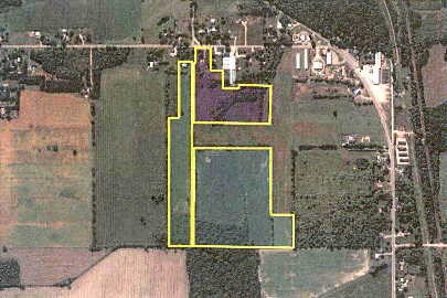
COM AT W 1/4 COR TH N 385' TO POB TH CONT N 2346.82' TH W 331.66' TH S 1712.49' TH W 140' TH S 550.02' TH W 191.07' TO POB
13-032-012-00
ALLEGAN
Agriculturalland
Michigan
B and X Area of moderate flood hazard, usually the area between the limits of the 100-year and 500-year floods.
14.77 AC
2025
Outlying Allegan County
2026
West Michigan
030502
NEARBY LISTINGS FOR SALE OR LEASE
-
-
No Photo
-
View all Wayland listings for sale on LoopNet.com
DEMOGRAPHICS near 137Th Ave
1 mile
3 mile
5 mile
2025 Total Population
2,880
7,230
16,663
2030 Population
2,941
7,328
16,740
Pop Growth 2025-2030
+ 2.12%
+ 1.36%
+ 0.46%
Average Age
38
38
38
2025 Total Households
1,133
2,703
5,926
HH Growth 2025-2030
+ 2.21%
+ 1.41%
+ 0.47%
Median Household Inc
$71,088
$76,723
$81,757
Avg Household Size
2.50
2.60
2.70
2025 Avg HH Vehicles
2.00
2.00
2.00
Median Home Value
$181,930
$216,756
$250,086
Median Year Built
1987
1986
1987
Nearby Places
Map Layers
Map Styles
 Street
 Aerial
Layers
 Traffic
 Biking
Places
Listings with unknown addresses are not visible on the map
- Restaurants
- Banks
- Shops
- Fitness
- Groceries
PUBLIC TRANSPORTATION
AIRPORT
Gerald R Ford International
Drive
Walk
Distance
Gerald R Ford International
34 min
22.4 mi
Freight Ports
Port Milwaukee
Drive
Walk
Distance
Port Milwaukee
302 min
257.9 mi
Nearby Properties
Address
Land Use
TOTAL SIZE
Lot Size
Zoning
Address
Land Use
TOTAL SIZE
Lot Size
Zoning
119.76 AC
Address
Land Use
TOTAL SIZE
Lot Size
Zoning
99,487 SF
14.18 AC
Address
Land Use
TOTAL SIZE
Lot Size
Zoning
64,863 SF
10.14 AC
Address
Land Use
TOTAL SIZE
Lot Size
Zoning
115,750 SF
60.34 AC
Address
Land Use
TOTAL SIZE
Lot Size
Zoning
60.53 AC
Address
Land Use
TOTAL SIZE
Lot Size
Zoning
69,034 SF
22.50 AC
Address
Land Use
TOTAL SIZE
Lot Size
Zoning
62,500 SF
18.89 AC
Address
Land Use
TOTAL SIZE
Lot Size
Zoning
81,396 SF
12.32 AC
Address
Land Use
TOTAL SIZE
Lot Size
Zoning
38,241 SF
2.33 AC
Address
Land Use
TOTAL SIZE
Lot Size
Zoning
70,748 SF
20.74 AC
Address
Land Use
TOTAL SIZE
Lot Size
Zoning
35,333 SF
50.49 AC
Address
Land Use
TOTAL SIZE
Lot Size
Zoning
170,318 SF
7.11 AC
Address
Land Use
TOTAL SIZE
Lot Size
Zoning
121,440 SF
8.89 AC
Address
Land Use
TOTAL SIZE
Lot Size
Zoning
41,595 SF
10.08 AC
Address
Land Use
TOTAL SIZE
Lot Size
Zoning
197.92 AC
Address
Land Use
TOTAL SIZE
Lot Size
Zoning
37,449 SF
7.38 AC
Address
Land Use
TOTAL SIZE
Lot Size
Zoning
33,164 SF
6.88 AC
Address
Land Use
TOTAL SIZE
Lot Size
Zoning
17,903 SF
2.05 AC
Address
Land Use
TOTAL SIZE
Lot Size
Zoning
46,060 SF
11.88 AC
Address
Land Use
TOTAL SIZE
Lot Size
Zoning
12,320 SF
4.96 AC
Address
Land Use
TOTAL SIZE
Lot Size
Zoning
12,000 SF
6.47 AC
Address
Land Use
TOTAL SIZE
Lot Size
Zoning
29,356 SF
2.49 AC
Address
Land Use
TOTAL SIZE
Lot Size
Zoning
7,104 SF
2.03 AC
Address
Land Use
TOTAL SIZE
Lot Size
Zoning
30,600 SF
Address
Land Use
TOTAL SIZE
Lot Size
Zoning
7,200 SF
77.64 AC
I INDUS
Address
Land Use
TOTAL SIZE
Lot Size
Zoning
7,948 SF
4.91 AC
Address
Land Use
TOTAL SIZE
Lot Size
Zoning
71,798 SF
11.11 AC
Address
Land Use
TOTAL SIZE
Lot Size
Zoning
19,800 SF
40.83 AC
Address
Land Use
TOTAL SIZE
Lot Size
Zoning
48.34 AC
Address
Land Use
TOTAL SIZE
Lot Size
Zoning
9,584 SF
2.47 AC
The World's #1 Commercial Real Estate Marketplace
Connect with us
© 2026 CoStar Group
The information above has been obtained from sources believed reliable. While we do not doubt its accuracy we have not verified it and make no guarantee, warranty or representation about it. It is your responsibility to independently confirm its accuracy and completeness. Any projections, opinions, assumptions, or estimates used are for example only and do not represent the current or future performance of the property. The value of this transaction to you depends on tax and other factors which should be evaluated by your tax, financial, and legal advisors. You and your advisors should conduct a careful, independent investigation of the property to determine to your satisfaction the suitability of the property for your needs.