Property Record
13827 247Th St, Rosedale, NY 11422
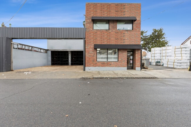
This Property Is For Sale
NEARBY LISTINGS FOR SALE OR LEASE
-
-
-
-
-
-
-
230-39 International Airport Ctr Blvd
Springfield Gardens, NY 11413
Negotiable
6,019 - 14,216 SF
Flex
-
View all Rosedale listings for sale on LoopNet.com
Property Detail
13827 247Th St
13621-0011
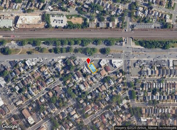
Rosedale Property Map 1
Storebuilding
Queens
X
New York
36059C0211G
11
2024
0.12 AC
2025
South Queens
065600
Long Island (New York)
5,840 SF
New York-Jersey City-White Plains, NY-NJ
DEMOGRAPHICS near 13827 247Th St
1 Mile
3 Mile
5 Mile
2024 Total Population
40,300
284,200
787,757
2029 Population
36,763
266,585
738,615
Pop Growth 2024-2029
(8.78%)
(6.20%)
(6.24%)
Average Age
42
42
41
2024 Total Households
12,116
87,959
244,476
HH Growth 2024-2029
(9.57%)
(6.66%)
(6.53%)
Median Household Inc
$101,615
$103,810
$92,914
Avg Household Size
3.20
3.10
3.10
2024 Avg HH Vehicles
2.00
2.00
1.00
Median Home Value
$629,758
$635,268
$661,686
Median Year Built
1954
1952
1952
Nearby Places
- Restaurants
- Banks
- Shops
- Fitness
- Groceries
PUBLIC TRANSPORTATION
TRANSIT/SUBWAY
Rosedale Station (Far Rockaway Branch - Long Island Rail Road)
DRIVE
WALK
Distance
Rosedale Station (Far Rockaway Branch - Long Island Rail Road)
1 min
6 min
0.3 mi
COMMUTER RAIL
Rosedale Station (Far Rockaway Branch - Long Island Rail Road)
DRIVE
WALK
Distance
Rosedale Station (Far Rockaway Branch - Long Island Rail Road)
1 min
6 min
0.3 mi
Laurelton Station (Far Rockaway Branch - Long Island Rail Road)
DRIVE
WALK
Distance
Laurelton Station (Far Rockaway Branch - Long Island Rail Road)
3 min
1.4 mi
AIRPORT
John F Kennedy International
DRIVE
WALK
Distance
John F Kennedy International
10 min
5.5 mi
LaGuardia
DRIVE
WALK
Distance
LaGuardia
21 min
12.5 mi
Newark Liberty International
DRIVE
WALK
Distance
Newark Liberty International
47 min
32.3 mi
Freight Ports
NY - Red Hook Container Terminal
DRIVE
WALK
Distance
NY - Red Hook Container Terminal
31 min
17.0 mi
Nearby Properties
Address
Land Use
TOTAL SIZE
Lot Size
Zoning
Address
Land Use
TOTAL SIZE
Lot Size
Zoning
182.50 AC
M1-1
Address
Land Use
TOTAL SIZE
Lot Size
Zoning
124.60 AC
M1-1
Address
Land Use
TOTAL SIZE
Lot Size
Zoning
294.47 AC
PARK
Address
Land Use
TOTAL SIZE
Lot Size
Zoning
731,247 SF
56.09 AC
R3-2
Address
Land Use
TOTAL SIZE
Lot Size
Zoning
208,952 SF
9.03 AC
M1-1
Address
Land Use
TOTAL SIZE
Lot Size
Zoning
285,170 SF
12.63 AC
R3-1
Address
Land Use
TOTAL SIZE
Lot Size
Zoning
27.23 AC
PARK
Address
Land Use
TOTAL SIZE
Lot Size
Zoning
50,000 SF
52.45 AC
PARK
Address
Land Use
TOTAL SIZE
Lot Size
Zoning
175,040 SF
10.19 AC
R3X
Address
Land Use
TOTAL SIZE
Lot Size
Zoning
129,378 SF
4.86 AC
R2A
Address
Land Use
TOTAL SIZE
Lot Size
Zoning
304,128 SF
3.70 AC
R6
Address
Land Use
TOTAL SIZE
Lot Size
Zoning
160,000 SF
4.02 AC
R3-2
Address
Land Use
TOTAL SIZE
Lot Size
Zoning
64,618 SF
8.04 AC
Address
Land Use
TOTAL SIZE
Lot Size
Zoning
165,600 SF
2.11 AC
R6
Address
Land Use
TOTAL SIZE
Lot Size
Zoning
93.35 AC
PARK
Address
Land Use
TOTAL SIZE
Lot Size
Zoning
178,870 SF
7.60 AC
M1-1
Address
Land Use
TOTAL SIZE
Lot Size
Zoning
122,080 SF
2.81 AC
R2
Address
Land Use
TOTAL SIZE
Lot Size
Zoning
875 SF
21.59 AC
PARK
Address
Land Use
TOTAL SIZE
Lot Size
Zoning
5,296 SF
37.42 AC
PARK
Address
Land Use
TOTAL SIZE
Lot Size
Zoning
138,000 SF
7.06 AC
R3-2
Address
Land Use
TOTAL SIZE
Lot Size
Zoning
213,338 SF
2.91 AC
R3X
Address
Land Use
TOTAL SIZE
Lot Size
Zoning
252,665 SF
7.50 AC
R3-2
Address
Land Use
TOTAL SIZE
Lot Size
Zoning
97,190 SF
1.75 AC
R3X
Address
Land Use
TOTAL SIZE
Lot Size
Zoning
170,000 SF
4.02 AC
R3-2
Address
Land Use
TOTAL SIZE
Lot Size
Zoning
56,385 SF
7.81 AC
R6
Address
Land Use
TOTAL SIZE
Lot Size
Zoning
75,410 SF
5.12 AC
M1-1
Address
Land Use
TOTAL SIZE
Lot Size
Zoning
78,380 SF
0.85 AC
R3-2
Address
Land Use
TOTAL SIZE
Lot Size
Zoning
806 SF
84.15 AC
R2A
Address
Land Use
TOTAL SIZE
Lot Size
Zoning
260,000 SF
4.14 AC
R2
Address
Land Use
TOTAL SIZE
Lot Size
Zoning
96,071 SF
5.58 AC
M1-1
The World's #1 Commercial Real Estate Marketplace
Connect with us
© 2025 CoStar Group
The information above has been obtained from sources believed reliable. While we do not doubt its accuracy we have not verified it and make no guarantee, warranty or representation about it. It is your responsibility to independently confirm its accuracy and completeness. Any projections, opinions, assumptions, or estimates used are for example only and do not represent the current or future performance of the property. The value of this transaction to you depends on tax and other factors which should be evaluated by your tax, financial, and legal advisors. You and your advisors should conduct a careful, independent investigation of the property to determine to your satisfaction the suitability of the property for your needs.