Property Record
138 Hansen Access Rd, King Of Prussia, PA 19406

NEARBY LISTINGS FOR SALE OR LEASE
Property Detail
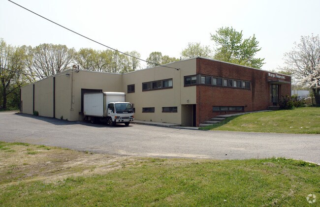
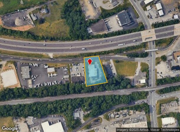
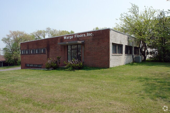
138 Hansen Access Rd
58-00-09225-005
ASSESSOR BLOCK-UNIT NUMBER 10E-47
Warehouse
Montgomery
X
Pennsylvania
42029C0120G
47
2024
1.35 AC
2025
East Montgomery Cty
205807
Philadelphia
10,444 SF
Philadelphia-Camden-Wilmington, PA-NJ-DE-MD
DEMOGRAPHICS near 138 Hansen Access Rd
1 Mile
3 Mile
5 Mile
2024 Total Population
9,202
87,910
213,595
2029 Population
9,447
89,557
218,059
Pop Growth 2024-2029
+ 2.66%
+ 1.87%
+ 2.09%
Average Age
38
38
40
2024 Total Households
4,027
34,424
84,041
HH Growth 2024-2029
+ 3.03%
+ 2.18%
+ 2.25%
Median Household Inc
$91,739
$87,588
$100,591
Avg Household Size
2.20
2.40
2.40
2024 Avg HH Vehicles
2.00
2.00
2.00
Median Home Value
$328,256
$354,652
$402,616
Median Year Built
1966
1964
1967
Nearby Places
Map Layers
Map Styles
 Street
 Aerial
- Restaurants
- Banks
- Shops
- Fitness
- Groceries
PUBLIC TRANSPORTATION
TRANSIT/SUBWAY
Hughes Park (Route 100 - Southeastern Pennsylvania Transportation Authority Rapid Transit (SEPTA Subway & Trolley))
DRIVE
WALK
Distance
Hughes Park (Route 100 - Southeastern Pennsylvania Transportation Authority Rapid Transit (SEPTA Subway & Trolley))
4 min
19 min
0.9 mi
COMMUTER RAIL
Norristown Transportation Center (R6 Line) (R6 - Southeastern Pennsylvania Transportation Authority Regional Rail (SEPTA Regional Rail))
DRIVE
WALK
Distance
Norristown Transportation Center (R6 Line) (R6 - Southeastern Pennsylvania Transportation Authority Regional Rail (SEPTA Regional Rail))
7 min
2.5 mi
Main Street (Norristown) (R6 - Southeastern Pennsylvania Transportation Authority Regional Rail (SEPTA Regional Rail))
DRIVE
WALK
Distance
Main Street (Norristown) (R6 - Southeastern Pennsylvania Transportation Authority Regional Rail (SEPTA Regional Rail))
6 min
2.9 mi
AIRPORT
Philadelphia International
DRIVE
WALK
Distance
Philadelphia International
40 min
25.0 mi
Trenton Mercer
DRIVE
WALK
Distance
Trenton Mercer
59 min
42.3 mi
Freight Ports
South Jersey Port
DRIVE
WALK
Distance
South Jersey Port
34 min
21.1 mi
Nearby Properties
Address
Land Use
TOTAL SIZE
Lot Size
Zoning
Address
Land Use
TOTAL SIZE
Lot Size
Zoning
2,373,472 SF
96.77 AC
SC
Address
Land Use
TOTAL SIZE
Lot Size
Zoning
222,980 SF
57.68 AC
Address
Land Use
TOTAL SIZE
Lot Size
Zoning
536,904 SF
8.84 AC
AG
Address
Land Use
TOTAL SIZE
Lot Size
Zoning
679,715 SF
58.23 AC
R2
Address
Land Use
TOTAL SIZE
Lot Size
Zoning
1,724,092 SF
24 AC
SC
Address
Land Use
TOTAL SIZE
Lot Size
Zoning
45,871 SF
112 AC
Address
Land Use
TOTAL SIZE
Lot Size
Zoning
520,066 SF
1.02 AC
HB
Address
Land Use
TOTAL SIZE
Lot Size
Zoning
628,694 SF
6.89 AC
AG
Address
Land Use
TOTAL SIZE
Lot Size
Zoning
649,339 SF
3.69 AC
AG
Address
Land Use
TOTAL SIZE
Lot Size
Zoning
137,282 SF
14.33 AC
Address
Land Use
TOTAL SIZE
Lot Size
Zoning
676,867 SF
2.98 AC
SP2
Address
Land Use
TOTAL SIZE
Lot Size
Zoning
546,664 SF
2.83 AC
AG
Address
Land Use
TOTAL SIZE
Lot Size
Zoning
388,042 SF
24.45 AC
SM
Address
Land Use
TOTAL SIZE
Lot Size
Zoning
470,032 SF
2.98 AC
SP2
Address
Land Use
TOTAL SIZE
Lot Size
Zoning
547,377 SF
3.28 AC
AG
Address
Land Use
TOTAL SIZE
Lot Size
Zoning
434,229 SF
3.24 AC
HI
Address
Land Use
TOTAL SIZE
Lot Size
Zoning
454,933 SF
17.85 AC
SM
Address
Land Use
TOTAL SIZE
Lot Size
Zoning
872,232 SF
51.99 AC
G
Address
Land Use
TOTAL SIZE
Lot Size
Zoning
583,559 SF
AG
Address
Land Use
TOTAL SIZE
Lot Size
Zoning
426,711 SF
6.04 AC
HI
Address
Land Use
TOTAL SIZE
Lot Size
Zoning
413,892 SF
21.94 AC
SM
Address
Land Use
TOTAL SIZE
Lot Size
Zoning
493,690 SF
4.75 AC
AG
Address
Land Use
TOTAL SIZE
Lot Size
Zoning
843,567 SF
50.79 AC
HI
Address
Land Use
TOTAL SIZE
Lot Size
Zoning
214,714 SF
22.23 AC
R1
Address
Land Use
TOTAL SIZE
Lot Size
Zoning
260,938 SF
9.81 AC
SM1
Address
Land Use
TOTAL SIZE
Lot Size
Zoning
311,353 SF
7.41 AC
SM1
Address
Land Use
TOTAL SIZE
Lot Size
Zoning
488,970 SF
24.68 AC
AR
Address
Land Use
TOTAL SIZE
Lot Size
Zoning
197,108 SF
2.08 AC
SC
Address
Land Use
TOTAL SIZE
Lot Size
Zoning
804,184 SF
26.72 AC
HR
Address
Land Use
TOTAL SIZE
Lot Size
Zoning
414,642 SF
3.70 AC
AG
The World's #1 Commercial Real Estate Marketplace
Connect with us
© 2025 CoStar Group
The information above has been obtained from sources believed reliable. While we do not doubt its accuracy we have not verified it and make no guarantee, warranty or representation about it. It is your responsibility to independently confirm its accuracy and completeness. Any projections, opinions, assumptions, or estimates used are for example only and do not represent the current or future performance of the property. The value of this transaction to you depends on tax and other factors which should be evaluated by your tax, financial, and legal advisors. You and your advisors should conduct a careful, independent investigation of the property to determine to your satisfaction the suitability of the property for your needs.