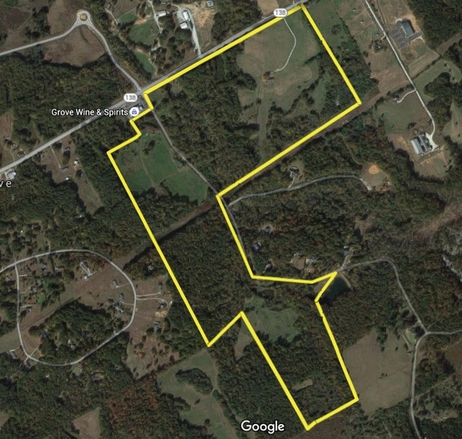
Property Record
138 Highway 138 Rd, Covington, GA 30014
NEARBY LISTINGS FOR SALE OR LEASE
Property Detail
138 Highway 138 Rd
Atlanta-Sandy Springs-Roswell, GA
Gerald Smith Prop 07&8
C064000000068000
#7/27.15AC
Residentialacreage
Walton
A
Georgia
13297C0125E
27.15 AC
2024
Walton County
2024
Atlanta
100302
DEMOGRAPHICS near 138 Highway 138 Rd
1 Mile
3 Mile
5 Mile
2024 Total Population
260
10,110
26,286
2029 Population
299
11,644
30,170
Pop Growth 2024-2029
+ 15.00%
+ 15.17%
+ 14.78%
Average Age
41
40
41
2024 Total Households
89
3,385
9,021
HH Growth 2024-2029
+ 15.73%
+ 15.51%
+ 15.10%
Median Household Inc
$82,954
$75,075
$82,447
Avg Household Size
2.90
2.90
2.90
2024 Avg HH Vehicles
2.00
3.00
3.00
Median Home Value
$281,999
$260,867
$271,560
Median Year Built
1997
1996
1997
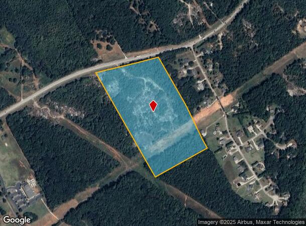
Nearby Places
Map Layers
Map Styles
 Street
 Aerial
- Restaurants
- Banks
- Shops
- Fitness
- Groceries
SALE & LEASE HISTORY
LISTING DATE
SALE/LEASE

Jan 24, 2017
For Sale
Nearby Properties
Address
Land Use
TOTAL SIZE
Lot Size
Zoning
Address
Land Use
TOTAL SIZE
Lot Size
Zoning
235,653 SF
103.54 AC
GPU
Address
Land Use
TOTAL SIZE
Lot Size
Zoning
148,320 SF
35.90 AC
A1
Address
Land Use
TOTAL SIZE
Lot Size
Zoning
56,491 SF
33.95 AC
A1 WP2
Address
Land Use
TOTAL SIZE
Lot Size
Zoning
31,464 SF
6.10 AC
B3
Address
Land Use
TOTAL SIZE
Lot Size
Zoning
2,646 SF
21.85 AC
A1 A2 WP2
Address
Land Use
TOTAL SIZE
Lot Size
Zoning
15,718 SF
45.40 AC
A1 WP2
Address
Land Use
TOTAL SIZE
Lot Size
Zoning
38,400 SF
27.76 AC
C2 WP2
Address
Land Use
TOTAL SIZE
Lot Size
Zoning
3,300 SF
6.35 AC
GPU
Address
Land Use
TOTAL SIZE
Lot Size
Zoning
181.22 AC
A1 WP2
Address
Land Use
TOTAL SIZE
Lot Size
Zoning
175.91 AC
A1
Address
Land Use
TOTAL SIZE
Lot Size
Zoning
170.63 AC
R1 WP2
Address
Land Use
TOTAL SIZE
Lot Size
Zoning
3,200 SF
16.05 AC
I1
Address
Land Use
TOTAL SIZE
Lot Size
Zoning
4,800 SF
7.06 AC
B2
Address
Land Use
TOTAL SIZE
Lot Size
Zoning
8,858 SF
12.48 AC
A1
Address
Land Use
TOTAL SIZE
Lot Size
Zoning
104.65 AC
A1
Address
Land Use
TOTAL SIZE
Lot Size
Zoning
7,140 SF
3.24 AC
C1 WP2
Address
Land Use
TOTAL SIZE
Lot Size
Zoning
12,602 SF
4.08 AC
C1 WP2
Address
Land Use
TOTAL SIZE
Lot Size
Zoning
2,000 SF
12.10 AC
I1
Address
Land Use
TOTAL SIZE
Lot Size
Zoning
11,084 SF
11.49 AC
A1
Address
Land Use
TOTAL SIZE
Lot Size
Zoning
125.30 AC
A1
Address
Land Use
TOTAL SIZE
Lot Size
Zoning
6,000 SF
3.79 AC
B3
Address
Land Use
TOTAL SIZE
Lot Size
Zoning
113.86 AC
A
Address
Land Use
TOTAL SIZE
Lot Size
Zoning
112.19 AC
A1 R1 WP2
Address
Land Use
TOTAL SIZE
Lot Size
Zoning
131.40 AC
A1 WP2
Address
Land Use
TOTAL SIZE
Lot Size
Zoning
3,680 SF
164.87 AC
R1
Address
Land Use
TOTAL SIZE
Lot Size
Zoning
9,205 SF
2 AC
B2
Address
Land Use
TOTAL SIZE
Lot Size
Zoning
99.77 AC
A1 WP2
Address
Land Use
TOTAL SIZE
Lot Size
Zoning
9,432 SF
1.41 AC
B3
Address
Land Use
TOTAL SIZE
Lot Size
Zoning
6,538 SF
4.23 AC
GPU WP2
Address
Land Use
TOTAL SIZE
Lot Size
Zoning
3,777 SF
4.56 AC
B3 WP2
The World's #1 Commercial Real Estate Marketplace
Connect with us
© 2025 CoStar Group
The information above has been obtained from sources believed reliable. While we do not doubt its accuracy we have not verified it and make no guarantee, warranty or representation about it. It is your responsibility to independently confirm its accuracy and completeness. Any projections, opinions, assumptions, or estimates used are for example only and do not represent the current or future performance of the property. The value of this transaction to you depends on tax and other factors which should be evaluated by your tax, financial, and legal advisors. You and your advisors should conduct a careful, independent investigation of the property to determine to your satisfaction the suitability of the property for your needs.