Property Record
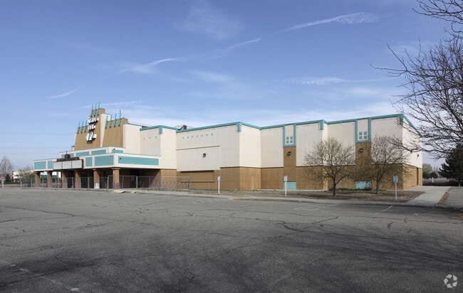
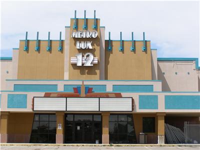
1380 Denver Ave, Loveland, CO 80537


Property Detail
1380 Denver Ave
85181-25-901
LOTS 1, 2, 3, 4, 5 AND TRACT A, BLK 1, AMD LOTS 1-22, BLK 1,LOVELAND BUSINESS PLAZA SUB, AND LOTS 16 & 17, BLK 2, LOVELAND BUSINESS PLAZA FIRST ADD, TOG W/ POR OF VACA ALLEY PER B2035, P404; LOV (20060075782) (COMBINE 85181-25-002, 85181-25-003, 8518
Religious
Larimer
B
Colorado
B and X Area of moderate flood hazard, usually the area between the limits of the 100-year and 500-year floods.
1
0
6.69 AC
2025
Fort Collins
001711
Denver
38,134 SF
Fort Collins-Loveland, CO
NEARBY LISTINGS FOR SALE OR LEASE
DEMOGRAPHICS near 1380 Denver Ave
1 mile
3 mile
5 mile
2024 Total Population
9,091
41,297
94,461
2029 Population
9,367
42,421
97,240
Pop Growth 2024-2029
+ 3.04%
+ 2.72%
+ 2.94%
Average Age
40
41
42
2024 Total Households
3,782
17,874
39,222
HH Growth 2024-2029
+ 3.07%
+ 2.79%
+ 3.04%
Median Household Inc
$81,845
$75,856
$85,281
Avg Household Size
2.30
2.20
2.40
2024 Avg HH Vehicles
2.00
2.00
2.00
Median Home Value
$472,853
$469,110
$495,701
Median Year Built
1997
1987
1993
Nearby Places
Map Layers
Map Styles
 Street
 Aerial
Transit
 Traffic
 Biking
Places
Listings with unknown addresses are not visible on the map
- Restaurants
- Banks
- Shops
- Fitness
- Groceries
Nearby Properties
Address
Land Use
TOTAL SIZE
Lot Size
Zoning
Address
Land Use
TOTAL SIZE
Lot Size
Zoning
689,698 SF
112.68 AC
P59
Address
Land Use
TOTAL SIZE
Lot Size
Zoning
444,114 SF
73.02 AC
Address
Land Use
TOTAL SIZE
Lot Size
Zoning
218,000 SF
45.72 AC
R1
Address
Land Use
TOTAL SIZE
Lot Size
Zoning
231,071 SF
23.80 AC
P12
Address
Land Use
TOTAL SIZE
Lot Size
Zoning
366,684 SF
29.44 AC
R3
Address
Land Use
TOTAL SIZE
Lot Size
Zoning
201,500 SF
28.43 AC
R1E
Address
Land Use
TOTAL SIZE
Lot Size
Zoning
125,566 SF
8.27 AC
R3E
Address
Land Use
TOTAL SIZE
Lot Size
Zoning
109,712 SF
8.49 AC
B
Address
Land Use
TOTAL SIZE
Lot Size
Zoning
120,688 SF
1.24 AC
Address
Land Use
TOTAL SIZE
Lot Size
Zoning
137,225 SF
25.76 AC
R1
Address
Land Use
TOTAL SIZE
Lot Size
Zoning
147,663 SF
5.01 AC
R3E
Address
Land Use
TOTAL SIZE
Lot Size
Zoning
84,548 SF
4.91 AC
P12
Address
Land Use
TOTAL SIZE
Lot Size
Zoning
35,554 SF
7.69 AC
Address
Land Use
TOTAL SIZE
Lot Size
Zoning
205,804 SF
22.74 AC
P51
Address
Land Use
TOTAL SIZE
Lot Size
Zoning
96,723 SF
9.16 AC
I
Address
Land Use
TOTAL SIZE
Lot Size
Zoning
83,954 SF
5.79 AC
FA
Address
Land Use
TOTAL SIZE
Lot Size
Zoning
101,362 SF
4.80 AC
Address
Land Use
TOTAL SIZE
Lot Size
Zoning
162,753 SF
13.39 AC
P59
Address
Land Use
TOTAL SIZE
Lot Size
Zoning
69,768 SF
13.41 AC
Address
Land Use
TOTAL SIZE
Lot Size
Zoning
326,329 SF
11.57 AC
Address
Land Use
TOTAL SIZE
Lot Size
Zoning
122,597 SF
6.57 AC
Address
Land Use
TOTAL SIZE
Lot Size
Zoning
122,597 SF
7.11 AC
Address
Land Use
TOTAL SIZE
Lot Size
Zoning
81,664 SF
0.95 AC
Address
Land Use
TOTAL SIZE
Lot Size
Zoning
139,289 SF
23.55 AC
I
Address
Land Use
TOTAL SIZE
Lot Size
Zoning
64,309 SF
14.54 AC
Address
Land Use
TOTAL SIZE
Lot Size
Zoning
123,130 SF
4.17 AC
Address
Land Use
TOTAL SIZE
Lot Size
Zoning
546,880 SF
20.27 AC
Address
Land Use
TOTAL SIZE
Lot Size
Zoning
48,924 SF
4.89 AC
Address
Land Use
TOTAL SIZE
Lot Size
Zoning
93,689 SF
2.93 AC
P12
Address
Land Use
TOTAL SIZE
Lot Size
Zoning
137,432 SF
12.89 AC
B
The World's #1 Commercial Real Estate Marketplace
Connect with us
© 2026 CoStar Group
The information above has been obtained from sources believed reliable. While we do not doubt its accuracy we have not verified it and make no guarantee, warranty or representation about it. It is your responsibility to independently confirm its accuracy and completeness. Any projections, opinions, assumptions, or estimates used are for example only and do not represent the current or future performance of the property. The value of this transaction to you depends on tax and other factors which should be evaluated by your tax, financial, and legal advisors. You and your advisors should conduct a careful, independent investigation of the property to determine to your satisfaction the suitability of the property for your needs.