No Photo
Property Record
1380 Towpath Ln, Fort Edward, NY 12828

Save to a Folder
{{folder.Name}}
{{folder.ListingIds.length}} Properties
{{folder.ListingIds.length}} Property
Create a New Folder
Property Detail
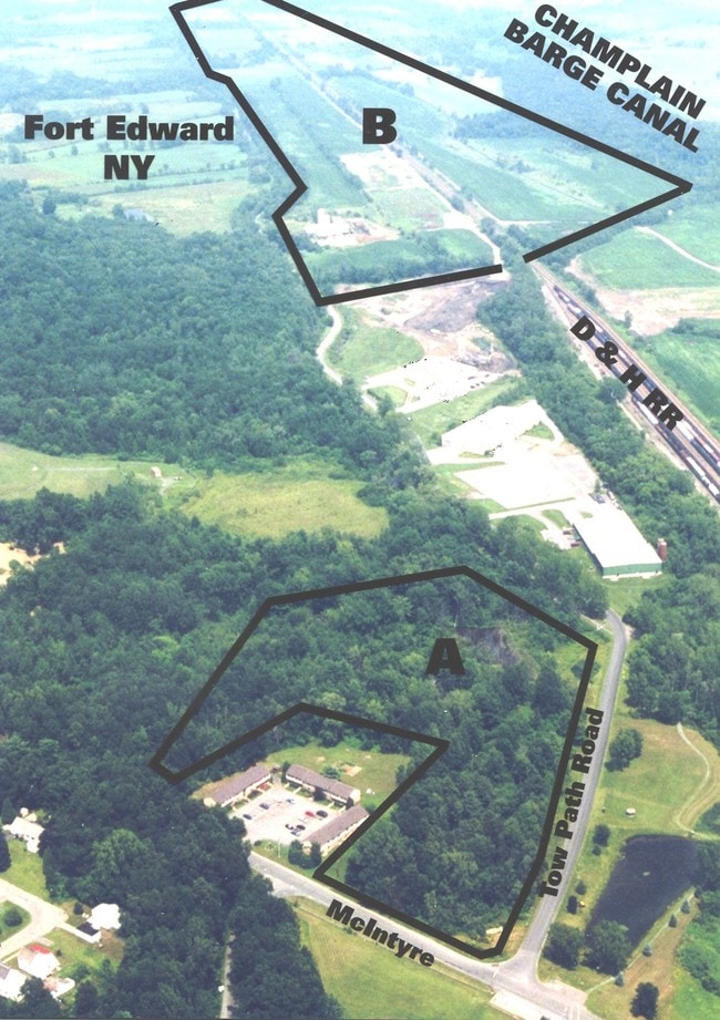
1380 Towpath Ln
Glens Falls, NY
FARMLAND
533089-163-000-0002-020-000-0000
WASHINGTON
Industrialgeneral
New York
M1
20.000
2025
169.40 AC
2025
Washington County
088002
Albany/Schenectady/Troy
1,362 SF
NEARBY LISTINGS FOR SALE OR LEASE
-
-
No Photo
-
View all Fort Edward listings for sale on LoopNet.com
DEMOGRAPHICS near 1380 Towpath Ln
1 mile
3 mile
5 mile
2025 Total Population
2,509
17,911
42,470
2030 Population
2,500
17,787
42,065
Pop Growth 2025-2030
(0.36%)
(0.69%)
(0.95%)
Average Age
43
41
42
2025 Total Households
1,015
7,534
18,464
HH Growth 2025-2030
0.00%
(0.81%)
(1.06%)
Median Household Inc
$64,733
$68,114
$69,780
Avg Household Size
2.30
2.30
2.20
2025 Avg HH Vehicles
2.00
2.00
2.00
Median Home Value
$158,405
$170,935
$202,511
Median Year Built
1949
1957
1957
Nearby Places
Map Layers
Map Styles
 Street
 Aerial
Layers
 Traffic
 Biking
Places
Listings with unknown addresses are not visible on the map
- Restaurants
- Banks
- Shops
- Fitness
- Groceries
PUBLIC TRANSPORTATION
COMMUTER RAIL
Fort Edward Amtrak (Adirondack - Amtrak, Ethan Allen Express - Amtrak)
Drive
Walk
Distance
Fort Edward Amtrak (Adirondack - Amtrak, Ethan Allen Express - Amtrak)
4 min
1.2 mi
Freight Ports
Albany, NY Port
Drive
Walk
Distance
Albany, NY Port
77 min
55.9 mi
Nearby Properties
Address
Land Use
TOTAL SIZE
Lot Size
Zoning
Address
Land Use
TOTAL SIZE
Lot Size
Zoning
16.34 AC
M1
Address
Land Use
TOTAL SIZE
Lot Size
Zoning
116,696 SF
23.70 AC
04 - FARM
Address
Land Use
TOTAL SIZE
Lot Size
Zoning
393,880 SF
23.90 AC
M1
Address
Land Use
TOTAL SIZE
Lot Size
Zoning
9,216 SF
32.20 AC
UR
Address
Land Use
TOTAL SIZE
Lot Size
Zoning
5,680 SF
39.79 AC
UR
Address
Land Use
TOTAL SIZE
Lot Size
Zoning
82,922 SF
8.03 AC
I
Address
Land Use
TOTAL SIZE
Lot Size
Zoning
Address
Land Use
TOTAL SIZE
Lot Size
Zoning
113.40 AC
04 - FARM
Address
Land Use
TOTAL SIZE
Lot Size
Zoning
89,902 SF
9.61 AC
05 - COMME
Address
Land Use
TOTAL SIZE
Lot Size
Zoning
136,449 SF
14.92 AC
LDR25
Address
Land Use
TOTAL SIZE
Lot Size
Zoning
7,823 SF
27.33 AC
LDR25
Address
Land Use
TOTAL SIZE
Lot Size
Zoning
6,549 SF
17.26 AC
M1
Address
Land Use
TOTAL SIZE
Lot Size
Zoning
20,250 SF
46.97 AC
HI
Address
Land Use
TOTAL SIZE
Lot Size
Zoning
3,000 SF
14.95 AC
M1
Address
Land Use
TOTAL SIZE
Lot Size
Zoning
18,133 SF
29.71 AC
LDR25
Address
Land Use
TOTAL SIZE
Lot Size
Zoning
119,455 SF
66.60 AC
LDR25
Address
Land Use
TOTAL SIZE
Lot Size
Zoning
42,156 SF
5.93 AC
05 - COMME
Address
Land Use
TOTAL SIZE
Lot Size
Zoning
134,998 SF
19.30 AC
05 - COMME
Address
Land Use
TOTAL SIZE
Lot Size
Zoning
141,480 SF
29.05 AC
RA
Address
Land Use
TOTAL SIZE
Lot Size
Zoning
56,884 SF
8.73 AC
R2
Address
Land Use
TOTAL SIZE
Lot Size
Zoning
106,209 SF
6.22 AC
M1
Address
Land Use
TOTAL SIZE
Lot Size
Zoning
41,280 SF
50.96 AC
M1
Address
Land Use
TOTAL SIZE
Lot Size
Zoning
Address
Land Use
TOTAL SIZE
Lot Size
Zoning
2,400 SF
27.88 AC
M1
Address
Land Use
TOTAL SIZE
Lot Size
Zoning
4,715 SF
43.55 AC
RP
Address
Land Use
TOTAL SIZE
Lot Size
Zoning
600 SF
62.72 AC
HI
Address
Land Use
TOTAL SIZE
Lot Size
Zoning
44,817 SF
2.75 AC
PUD
Address
Land Use
TOTAL SIZE
Lot Size
Zoning
75,156 SF
2.78 AC
RA
Address
Land Use
TOTAL SIZE
Lot Size
Zoning
4,200 SF
9.99 AC
LDR25
Address
Land Use
TOTAL SIZE
Lot Size
Zoning
36,249 SF
5.40 AC
COM1A
The World's #1 Commercial Real Estate Marketplace
Connect with us
© 2026 CoStar Group
The information above has been obtained from sources believed reliable. While we do not doubt its accuracy we have not verified it and make no guarantee, warranty or representation about it. It is your responsibility to independently confirm its accuracy and completeness. Any projections, opinions, assumptions, or estimates used are for example only and do not represent the current or future performance of the property. The value of this transaction to you depends on tax and other factors which should be evaluated by your tax, financial, and legal advisors. You and your advisors should conduct a careful, independent investigation of the property to determine to your satisfaction the suitability of the property for your needs.