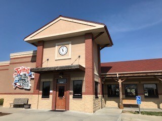
Property Record
13803 W 63Rd St, Shawnee, KS 66216
NEARBY LISTINGS FOR SALE OR LEASE
Property Detail
13803 W 63Rd St
Kansas City, MO-KS
Widmer Retail Center First Plat
QP87570000-0005
WIDMER RETAIL CENTER THIRD PLAT LT 5
Regionalshoppingcenterormallwithanchorstore
Johnson
X
Kansas
20209C0165D
5
2024
4.64 AC
2024
Northwest Johnson County
052308
Kansas City
25,898 SF
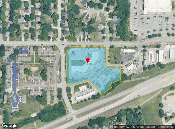
DEMOGRAPHICS near 13803 W 63Rd St
1 Mile
3 Mile
5 Mile
2024 Total Population
9,532
65,114
164,086
2029 Population
9,843
67,448
169,354
Pop Growth 2024-2029
+ 3.26%
+ 3.58%
+ 3.21%
Average Age
41
41
40
2024 Total Households
3,607
27,391
70,377
HH Growth 2024-2029
+ 3.35%
+ 3.72%
+ 3.45%
Median Household Inc
$91,503
$79,944
$75,978
Avg Household Size
2.50
2.30
2.30
2024 Avg HH Vehicles
2.00
2.00
2.00
Median Home Value
$272,170
$278,317
$260,043
Median Year Built
1980
1978
1975
Nearby Places
Map Layers
Map Styles
 Street
 Aerial
- Restaurants
- Banks
- Shops
- Fitness
- Groceries
PUBLIC TRANSPORTATION
AIRPORT
Kansas City International
DRIVE
WALK
Distance
Kansas City International
31 min
33.0 mi
Freight Ports
Port of Shreveport
DRIVE
WALK
Distance
Port of Shreveport
1 min
464.3 mi
Nearby Properties
Address
Land Use
TOTAL SIZE
Lot Size
Zoning
Address
Land Use
TOTAL SIZE
Lot Size
Zoning
279,588 SF
19.50 AC
RP5
Address
Land Use
TOTAL SIZE
Lot Size
Zoning
203,079 SF
8.10 AC
BP2
Address
Land Use
TOTAL SIZE
Lot Size
Zoning
202,842 SF
10.20 AC
PD
Address
Land Use
TOTAL SIZE
Lot Size
Zoning
83,537 SF
27.65 AC
AG
Address
Land Use
TOTAL SIZE
Lot Size
Zoning
89,477 SF
16.45 AC
R-1
Address
Land Use
TOTAL SIZE
Lot Size
Zoning
75,010 SF
5.53 AC
PD
Address
Land Use
TOTAL SIZE
Lot Size
Zoning
85,940 SF
9.08 AC
RGA
Address
Land Use
TOTAL SIZE
Lot Size
Zoning
96,856 SF
15.76 AC
R-1
Address
Land Use
TOTAL SIZE
Lot Size
Zoning
139,880 SF
17.18 AC
R1
Address
Land Use
TOTAL SIZE
Lot Size
Zoning
88,866 SF
21.54 AC
RS
Address
Land Use
TOTAL SIZE
Lot Size
Zoning
81,361 SF
3.81 AC
AG
Address
Land Use
TOTAL SIZE
Lot Size
Zoning
70,952 SF
9.98 AC
R-1
Address
Land Use
TOTAL SIZE
Lot Size
Zoning
77,758 SF
4.89 AC
R-1
Address
Land Use
TOTAL SIZE
Lot Size
Zoning
35,848 SF
74.74 AC
R1
Address
Land Use
TOTAL SIZE
Lot Size
Zoning
667,586 SF
18.06 AC
PUD-G
Address
Land Use
TOTAL SIZE
Lot Size
Zoning
34,745 SF
8.96 AC
PARK
Address
Land Use
TOTAL SIZE
Lot Size
Zoning
34,641 SF
14.33 AC
AG
Address
Land Use
TOTAL SIZE
Lot Size
Zoning
42,603 SF
17.67 AC
AG
Address
Land Use
TOTAL SIZE
Lot Size
Zoning
83,915 SF
12.61 AC
R1
Address
Land Use
TOTAL SIZE
Lot Size
Zoning
80,474 SF
11.30 AC
R-1
Address
Land Use
TOTAL SIZE
Lot Size
Zoning
297,730 SF
15.75 AC
CN
Address
Land Use
TOTAL SIZE
Lot Size
Zoning
77,375 SF
9.22 AC
R-1
Address
Land Use
TOTAL SIZE
Lot Size
Zoning
152,721 SF
14.47 AC
PI
Address
Land Use
TOTAL SIZE
Lot Size
Zoning
63,754 SF
9.41 AC
R1
Address
Land Use
TOTAL SIZE
Lot Size
Zoning
24,087 SF
35.11 AC
R1
Address
Land Use
TOTAL SIZE
Lot Size
Zoning
69,451 SF
9.54 AC
R1
Address
Land Use
TOTAL SIZE
Lot Size
Zoning
26,049 SF
10.53 AC
PD
Address
Land Use
TOTAL SIZE
Lot Size
Zoning
30,025 SF
148.34 AC
AG
Address
Land Use
TOTAL SIZE
Lot Size
Zoning
46,850 SF
0.89 AC
PO
Address
Land Use
TOTAL SIZE
Lot Size
Zoning
58,106 SF
6.24 AC
+
The World's #1 Commercial Real Estate Marketplace
Connect with us
© 2025 CoStar Group
The information above has been obtained from sources believed reliable. While we do not doubt its accuracy we have not verified it and make no guarantee, warranty or representation about it. It is your responsibility to independently confirm its accuracy and completeness. Any projections, opinions, assumptions, or estimates used are for example only and do not represent the current or future performance of the property. The value of this transaction to you depends on tax and other factors which should be evaluated by your tax, financial, and legal advisors. You and your advisors should conduct a careful, independent investigation of the property to determine to your satisfaction the suitability of the property for your needs.