Property Record
13809 E Carlisle Ave, Spokane, WA 99216
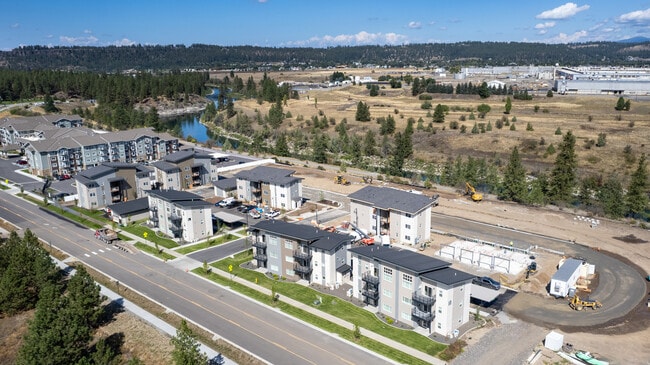

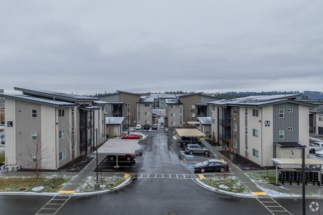
Property Detail
13809 E Carlisle Ave
Spokane-Spokane Valley, WA
11-25-44 PTN SW & NW : LOT 16 OF MIRABEAU BINDING SITE PLAN BSP-2020-0002, RECORDED IN BOOK 4 OF BINDING SITE PLANS, PAGES 68-69, EXCEPT THAT PORTION OF SAID LOT 16 DESCRIBED AS FOLLOWS: COMMENCING AT THE SOUTHEAST CORNER OF SAID LOT 16; THENCE N2244
45115.0413
Spokane
Apartment
Washington
B and X Area of moderate flood hazard, usually the area between the limits of the 100-year and 500-year floods.
16
2026
3.81 AC
2026
Mirabeau
011702
Spokane
88,605 SF
NEARBY LISTINGS FOR SALE OR LEASE
DEMOGRAPHICS near 13809 E Carlisle Ave
1 mile
3 mile
5 mile
2025 Total Population
7,499
66,345
129,978
2030 Population
7,656
68,016
133,137
Pop Growth 2025-2030
+ 2.09%
+ 2.52%
+ 2.43%
Average Age
37
40
41
2025 Total Households
3,498
27,444
51,634
HH Growth 2025-2030
+ 2.09%
+ 2.50%
+ 2.38%
Median Household Inc
$65,573
$70,113
$78,402
Avg Household Size
2.10
2.40
2.50
2025 Avg HH Vehicles
2.00
2.00
2.00
Median Home Value
$425,728
$388,350
$423,060
Median Year Built
1995
1985
1984
Nearby Places
Map Layers
Map Styles
 Street
 Aerial
Layers
 Traffic
 Biking
Places
Listings with unknown addresses are not visible on the map
- Restaurants
- Banks
- Shops
- Fitness
- Groceries
PUBLIC TRANSPORTATION
AIRPORT
Spokane International
Drive
Walk
Distance
Spokane International
24 min
16.2 mi
Freight Ports
Port of Everett
Drive
Walk
Distance
Port of Everett
352 min
311.8 mi
Nearby Properties
Address
Land Use
TOTAL SIZE
Lot Size
Zoning
Address
Land Use
TOTAL SIZE
Lot Size
Zoning
2,818,475 SF
466.05 AC
I-2
Address
Land Use
TOTAL SIZE
Lot Size
Zoning
1,077,082 SF
85.91 AC
I-2
Address
Land Use
TOTAL SIZE
Lot Size
Zoning
374,043 SF
58.56 AC
R-3
Address
Land Use
TOTAL SIZE
Lot Size
Zoning
130,380 SF
11.10 AC
MUC
Address
Land Use
TOTAL SIZE
Lot Size
Zoning
3,684,334 SF
244.85 AC
I-2
Address
Land Use
TOTAL SIZE
Lot Size
Zoning
373,118 SF
12.44 AC
MUC
Address
Land Use
TOTAL SIZE
Lot Size
Zoning
169,003 SF
5.18 AC
MUC
Address
Land Use
TOTAL SIZE
Lot Size
Zoning
500,460 SF
28.62 AC
Address
Land Use
TOTAL SIZE
Lot Size
Zoning
216,965 SF
10.70 AC
MUC
Address
Land Use
TOTAL SIZE
Lot Size
Zoning
248,117 SF
13.42 AC
MF-2
Address
Land Use
TOTAL SIZE
Lot Size
Zoning
320,056 SF
13.64 AC
MF-2
Address
Land Use
TOTAL SIZE
Lot Size
Zoning
323,993 SF
10.97 AC
MUC
Address
Land Use
TOTAL SIZE
Lot Size
Zoning
299,232 SF
16.28 AC
MF-2
Address
Land Use
TOTAL SIZE
Lot Size
Zoning
197,868 SF
7.15 AC
MUC
Address
Land Use
TOTAL SIZE
Lot Size
Zoning
192,698 SF
9.55 AC
MUC
Address
Land Use
TOTAL SIZE
Lot Size
Zoning
240,663 SF
8.90 AC
MF-2
Address
Land Use
TOTAL SIZE
Lot Size
Zoning
227,044 SF
7.20 AC
MUC
Address
Land Use
TOTAL SIZE
Lot Size
Zoning
123,400 SF
4.50 AC
MUC
Address
Land Use
TOTAL SIZE
Lot Size
Zoning
161,130 SF
6.45 AC
GO
Address
Land Use
TOTAL SIZE
Lot Size
Zoning
Address
Land Use
TOTAL SIZE
Lot Size
Zoning
84,600 SF
17.95 AC
MF-1
Address
Land Use
TOTAL SIZE
Lot Size
Zoning
136,518 SF
7.96 AC
O
Address
Land Use
TOTAL SIZE
Lot Size
Zoning
204,727 SF
8.60 AC
MUC
Address
Land Use
TOTAL SIZE
Lot Size
Zoning
100,060 SF
14.94 AC
R-3
Address
Land Use
TOTAL SIZE
Lot Size
Zoning
211,111 SF
8.81 AC
CMU
Address
Land Use
TOTAL SIZE
Lot Size
Zoning
231,172 SF
19.20 AC
RC
Address
Land Use
TOTAL SIZE
Lot Size
Zoning
74,291 SF
10.96 AC
R-3
Address
Land Use
TOTAL SIZE
Lot Size
Zoning
139,122 SF
6.17 AC
MUC
Address
Land Use
TOTAL SIZE
Lot Size
Zoning
192,384 SF
9.63 AC
I-2
Address
Land Use
TOTAL SIZE
Lot Size
Zoning
138,379 SF
17.39 AC
RC
The World's #1 Commercial Real Estate Marketplace
Connect with us
© 2026 CoStar Group
The information above has been obtained from sources believed reliable. While we do not doubt its accuracy we have not verified it and make no guarantee, warranty or representation about it. It is your responsibility to independently confirm its accuracy and completeness. Any projections, opinions, assumptions, or estimates used are for example only and do not represent the current or future performance of the property. The value of this transaction to you depends on tax and other factors which should be evaluated by your tax, financial, and legal advisors. You and your advisors should conduct a careful, independent investigation of the property to determine to your satisfaction the suitability of the property for your needs.