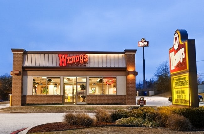
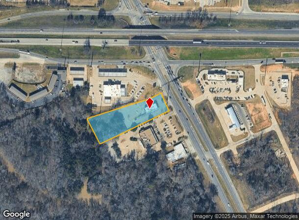
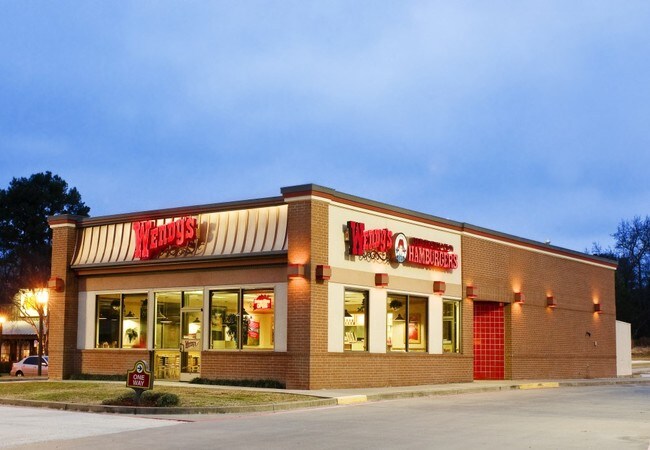
Property Record
13815 Us Highway 69 N, Tyler, TX 75706
NEARBY LISTINGS FOR SALE OR LEASE
-
-
View all Tyler listings for lease on LoopNet.com
Property Detail
13815 Us Highway 69 N
1-00000-0371-00-023001
A0371 S Grace
Restaurantbuilding
ABST A0371 S GRACETRACT 23.1
X
Smith
48423C0225D
Texas
2024
1.95 AC
2025
Tyler & Longview
001408
Other Market Areas
2,602 SF
Tyler, TX
DEMOGRAPHICS near 13815 Us Highway 69 N
1 Mile
3 Mile
5 Mile
2024 Total Population
433
7,567
22,364
2029 Population
480
8,328
24,530
Pop Growth 2024-2029
+ 10.85%
+ 10.06%
+ 9.69%
Average Age
37
38
40
2024 Total Households
155
2,676
8,218
HH Growth 2024-2029
+ 9.68%
+ 9.45%
+ 9.09%
Median Household Inc
$73,420
$72,582
$75,057
Avg Household Size
2.80
2.80
2.70
2024 Avg HH Vehicles
2.00
2.00
2.00
Median Home Value
$217,500
$205,556
$218,730
Median Year Built
2005
1996
1991
Nearby Places
Map Layers
Map Styles
 Street
 Aerial
- Restaurants
- Banks
- Shops
- Fitness
- Groceries
PUBLIC TRANSPORTATION
AIRPORT
Tyler Pounds Regional
DRIVE
WALK
Distance
Tyler Pounds Regional
20 min
13.0 mi
SALE & LEASE HISTORY
LISTING DATE
SALE/LEASE

Sep 25, 2016
For Lease
Nearby Properties
Address
Land Use
TOTAL SIZE
Lot Size
Zoning
Address
Land Use
TOTAL SIZE
Lot Size
Zoning
1,680,000 SF
145.53 AC
Address
Land Use
TOTAL SIZE
Lot Size
Zoning
72,185 SF
17.53 AC
Address
Land Use
TOTAL SIZE
Lot Size
Zoning
28,988 SF
7.66 AC
Address
Land Use
TOTAL SIZE
Lot Size
Zoning
32,238 SF
10.61 AC
Address
Land Use
TOTAL SIZE
Lot Size
Zoning
163,900 SF
27.35 AC
Address
Land Use
TOTAL SIZE
Lot Size
Zoning
156,758 SF
21.96 AC
Address
Land Use
TOTAL SIZE
Lot Size
Zoning
104,953 SF
6.37 AC
Address
Land Use
TOTAL SIZE
Lot Size
Zoning
4,200 SF
7.93 AC
Address
Land Use
TOTAL SIZE
Lot Size
Zoning
136,846 SF
15.10 AC
Address
Land Use
TOTAL SIZE
Lot Size
Zoning
95,278 SF
4.60 AC
Address
Land Use
TOTAL SIZE
Lot Size
Zoning
3,200 SF
3.47 AC
Address
Land Use
TOTAL SIZE
Lot Size
Zoning
16,625 SF
5.82 AC
Address
Land Use
TOTAL SIZE
Lot Size
Zoning
48,777 SF
3.18 AC
Address
Land Use
TOTAL SIZE
Lot Size
Zoning
7,822 SF
7.59 AC
Address
Land Use
TOTAL SIZE
Lot Size
Zoning
34,596 SF
2.24 AC
Address
Land Use
TOTAL SIZE
Lot Size
Zoning
48,016 SF
2 AC
Address
Land Use
TOTAL SIZE
Lot Size
Zoning
49,750 SF
44 AC
Address
Land Use
TOTAL SIZE
Lot Size
Zoning
19,600 SF
2.76 AC
Address
Land Use
TOTAL SIZE
Lot Size
Zoning
41,612 SF
1.50 AC
Address
Land Use
TOTAL SIZE
Lot Size
Zoning
7,071 SF
2.76 AC
Address
Land Use
TOTAL SIZE
Lot Size
Zoning
3,132 SF
2.77 AC
Address
Land Use
TOTAL SIZE
Lot Size
Zoning
10,164 SF
0.91 AC
Address
Land Use
TOTAL SIZE
Lot Size
Zoning
69,410 SF
3.10 AC
Address
Land Use
TOTAL SIZE
Lot Size
Zoning
10,850 SF
3.18 AC
Address
Land Use
TOTAL SIZE
Lot Size
Zoning
4,851 SF
1.98 AC
Address
Land Use
TOTAL SIZE
Lot Size
Zoning
5,894 SF
1.47 AC
Address
Land Use
TOTAL SIZE
Lot Size
Zoning
24,824 SF
1.62 AC
Address
Land Use
TOTAL SIZE
Lot Size
Zoning
9,708 SF
2.76 AC
Address
Land Use
TOTAL SIZE
Lot Size
Zoning
Address
Land Use
TOTAL SIZE
Lot Size
Zoning
7,121 SF
4.90 AC
The World's #1 Commercial Real Estate Marketplace
Connect with us
© 2026 CoStar Group
The information above has been obtained from sources believed reliable. While we do not doubt its accuracy we have not verified it and make no guarantee, warranty or representation about it. It is your responsibility to independently confirm its accuracy and completeness. Any projections, opinions, assumptions, or estimates used are for example only and do not represent the current or future performance of the property. The value of this transaction to you depends on tax and other factors which should be evaluated by your tax, financial, and legal advisors. You and your advisors should conduct a careful, independent investigation of the property to determine to your satisfaction the suitability of the property for your needs.