Property Record
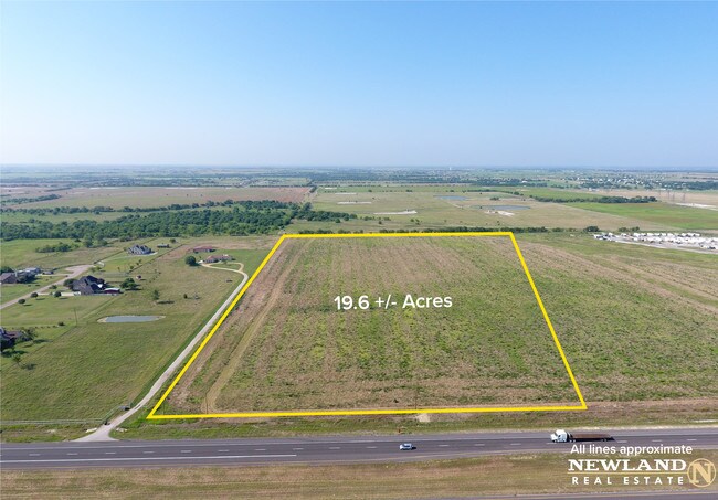
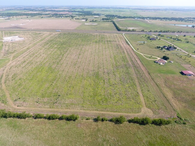
13817 Us Highway 380 W, Krum, TX 76249

Property Detail
13817 Us Highway 380 W
R113876
A1319A WINFREY, TR 11, 19.6161 ACRES, OLD DCAD TR #5D
Commercialnec
Denton
B and X Area of moderate flood hazard, usually the area between the limits of the 100-year and 500-year floods.
Texas
2024
19.62 AC
2025
Outlying Denton County
020206
Dallas/Ft Worth
53,384 SF
Dallas-Fort Worth-Arlington, TX
NEARBY LISTINGS FOR SALE OR LEASE
DEMOGRAPHICS near 13817 Us Highway 380 W
1 mile
3 mile
5 mile
2025 Total Population
38
2,467
16,251
2030 Population
44
2,790
18,412
Pop Growth 2025-2030
+ 15.79%
+ 13.09%
+ 13.30%
Average Age
43
41
39
2025 Total Households
14
856
5,455
HH Growth 2025-2030
+ 14.29%
+ 13.32%
+ 13.53%
Median Household Inc
$112,500
$105,216
$113,725
Avg Household Size
2.60
2.90
3.00
2025 Avg HH Vehicles
3.00
3.00
2.00
Median Home Value
$550,000
$473,619
$468,199
Median Year Built
1997
1999
2004
Nearby Places
Map Layers
Map Styles
 Street
 Aerial
Transit
 Traffic
 Biking
Places
Listings with unknown addresses are not visible on the map
- Restaurants
- Banks
- Shops
- Fitness
- Groceries
PUBLIC TRANSPORTATION
AIRPORT
Dallas-Fort Worth International
Drive
Walk
Distance
Dallas-Fort Worth International
43 min
35.6 mi
Freight Ports
Port of Shreveport
Drive
Walk
Distance
Port of Shreveport
262 min
242.2 mi
SALE & LEASE HISTORY
LISTING DATE
SALE/LEASE

Jul 10, 2019
For Sale
Nearby Properties
Address
Land Use
TOTAL SIZE
Lot Size
Zoning
Address
Land Use
TOTAL SIZE
Lot Size
Zoning
25,650 SF
12.14 AC
Address
Land Use
TOTAL SIZE
Lot Size
Zoning
81,856 SF
30 AC
Address
Land Use
TOTAL SIZE
Lot Size
Zoning
21,000 SF
20.42 AC
Address
Land Use
TOTAL SIZE
Lot Size
Zoning
23,082 SF
4 AC
Address
Land Use
TOTAL SIZE
Lot Size
Zoning
336 SF
28.59 AC
Address
Land Use
TOTAL SIZE
Lot Size
Zoning
49,000 SF
18.63 AC
Address
Land Use
TOTAL SIZE
Lot Size
Zoning
60,000 SF
7.36 AC
Address
Land Use
TOTAL SIZE
Lot Size
Zoning
32,800 SF
5.93 AC
Address
Land Use
TOTAL SIZE
Lot Size
Zoning
49,656 SF
5 AC
Address
Land Use
TOTAL SIZE
Lot Size
Zoning
48,400 SF
10.30 AC
Address
Land Use
TOTAL SIZE
Lot Size
Zoning
55,150 SF
6.47 AC
Address
Land Use
TOTAL SIZE
Lot Size
Zoning
146.99 AC
Address
Land Use
TOTAL SIZE
Lot Size
Zoning
9,258 SF
4 AC
Address
Land Use
TOTAL SIZE
Lot Size
Zoning
6,450 SF
17.63 AC
Address
Land Use
TOTAL SIZE
Lot Size
Zoning
5,500 SF
12.65 AC
Address
Land Use
TOTAL SIZE
Lot Size
Zoning
6,368 SF
155.59 AC
Address
Land Use
TOTAL SIZE
Lot Size
Zoning
36,292 SF
2.20 AC
Address
Land Use
TOTAL SIZE
Lot Size
Zoning
30 AC
Address
Land Use
TOTAL SIZE
Lot Size
Zoning
15,760 SF
7.64 AC
Address
Land Use
TOTAL SIZE
Lot Size
Zoning
10.83 AC
Address
Land Use
TOTAL SIZE
Lot Size
Zoning
41 SF
21.76 AC
Address
Land Use
TOTAL SIZE
Lot Size
Zoning
102.90 AC
Address
Land Use
TOTAL SIZE
Lot Size
Zoning
16,250 SF
6.89 AC
Address
Land Use
TOTAL SIZE
Lot Size
Zoning
15,000 SF
2 AC
Address
Land Use
TOTAL SIZE
Lot Size
Zoning
26,985 SF
3.03 AC
Address
Land Use
TOTAL SIZE
Lot Size
Zoning
2,585 SF
89.43 AC
Address
Land Use
TOTAL SIZE
Lot Size
Zoning
8.26 AC
Address
Land Use
TOTAL SIZE
Lot Size
Zoning
27,216 SF
2.50 AC
The World's #1 Commercial Real Estate Marketplace
Connect with us
© 2026 CoStar Group
The information above has been obtained from sources believed reliable. While we do not doubt its accuracy we have not verified it and make no guarantee, warranty or representation about it. It is your responsibility to independently confirm its accuracy and completeness. Any projections, opinions, assumptions, or estimates used are for example only and do not represent the current or future performance of the property. The value of this transaction to you depends on tax and other factors which should be evaluated by your tax, financial, and legal advisors. You and your advisors should conduct a careful, independent investigation of the property to determine to your satisfaction the suitability of the property for your needs.