Property Record
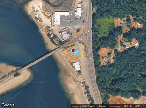
13818 Purdy Dr Nw, Gig Harbor, WA 98332
NEARBY LISTINGS FOR SALE OR LEASE
-
-
View all Gig Harbor listings for sale on LoopNet.com
Property Detail
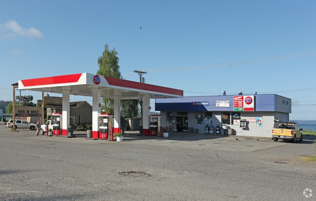
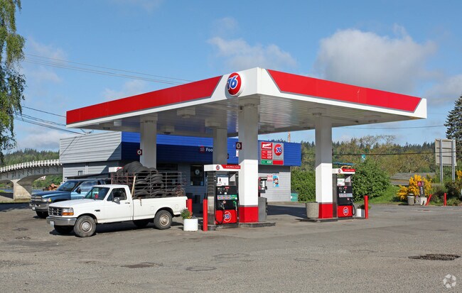
13818 Purdy Dr Nw
012224-2032
SECTION 24 TOWNSHIP 22 RANGE 01 QUARTER 23 : COM AT NW COR OF TR CYD TO PEARL M HEATON & EVELYN H JACKSON BY WD 7/26/55 FEE # 1728241 TH N 85 DEG 12 MIN 36 SEC E 149.29 FT TO WLY LI OF STATE HWY # 14 TH ALG SD WLY LI N 05 DEG 33 MIN 24 SEC W 85.92 FT
Servicestationmarket
Pierce
AE
Washington
53053C0050E
0.25 AC
2024
Gig Harbor/W Pierce Co
2025
Seattle/Puget Sound
072504
Seattle-Tacoma-Bellevue, WA
1,353 SF
DEMOGRAPHICS near 13818 Purdy Dr Nw
1 Mile
3 Mile
5 Mile
2024 Total Population
2,398
21,241
47,140
2029 Population
2,459
21,815
48,320
Pop Growth 2024-2029
+ 2.54%
+ 2.70%
+ 2.50%
Average Age
43
43
44
2024 Total Households
752
7,735
17,780
HH Growth 2024-2029
+ 2.66%
+ 2.74%
+ 2.58%
Median Household Inc
$120,605
$118,501
$115,219
Avg Household Size
2.60
2.60
2.60
2024 Avg HH Vehicles
2.00
2.00
2.00
Median Home Value
$698,834
$685,732
$651,945
Median Year Built
1992
1994
1991
Nearby Places
Map Layers
Map Styles
 Street
 Aerial
- Restaurants
- Banks
- Shops
- Fitness
- Groceries
PUBLIC TRANSPORTATION
AIRPORT
Seattle-Tacoma International
DRIVE
WALK
Distance
Seattle-Tacoma International
53 min
36.9 mi
Freight Ports
Port of Tacoma
DRIVE
WALK
Distance
Port of Tacoma
25 min
18.4 mi
Nearby Properties
Address
Land Use
TOTAL SIZE
Lot Size
Zoning
Address
Land Use
TOTAL SIZE
Lot Size
Zoning
308,000 SF
23.44 AC
PCD-BP
Address
Land Use
TOTAL SIZE
Lot Size
Zoning
427,880 SF
17.97 AC
GIGH
Address
Land Use
TOTAL SIZE
Lot Size
Zoning
318,450 SF
36.63 AC
ED
Address
Land Use
TOTAL SIZE
Lot Size
Zoning
192,969 SF
11.52 AC
PRD
Address
Land Use
TOTAL SIZE
Lot Size
Zoning
321,717 SF
75.30 AC
PI
Address
Land Use
TOTAL SIZE
Lot Size
Zoning
87,475 SF
11 AC
Address
Land Use
TOTAL SIZE
Lot Size
Zoning
71,494 SF
14.14 AC
Address
Land Use
TOTAL SIZE
Lot Size
Zoning
151,391 SF
17.49 AC
PCD-C
Address
Land Use
TOTAL SIZE
Lot Size
Zoning
92,797 SF
0.69 AC
PCD-BP
Address
Land Use
TOTAL SIZE
Lot Size
Zoning
295,242 SF
62 AC
PI
Address
Land Use
TOTAL SIZE
Lot Size
Zoning
122,520 SF
10.76 AC
PCD-C
Address
Land Use
TOTAL SIZE
Lot Size
Zoning
122,080 SF
16 AC
PCD-C
Address
Land Use
TOTAL SIZE
Lot Size
Zoning
57,560 SF
5.43 AC
PCD-C
Address
Land Use
TOTAL SIZE
Lot Size
Zoning
29,470 SF
3.46 AC
PCD-C
Address
Land Use
TOTAL SIZE
Lot Size
Zoning
56,504 SF
12.44 AC
Address
Land Use
TOTAL SIZE
Lot Size
Zoning
18.56 AC
PCD-BP
Address
Land Use
TOTAL SIZE
Lot Size
Zoning
14,039 SF
162.18 AC
MPC
Address
Land Use
TOTAL SIZE
Lot Size
Zoning
24,460 SF
19.80 AC
SF
Address
Land Use
TOTAL SIZE
Lot Size
Zoning
32,487 SF
2.70 AC
PCD-C
Address
Land Use
TOTAL SIZE
Lot Size
Zoning
55,904 SF
10.40 AC
CE
Address
Land Use
TOTAL SIZE
Lot Size
Zoning
40,090 SF
2.35 AC
ED
Address
Land Use
TOTAL SIZE
Lot Size
Zoning
24,354 SF
1.80 AC
MPC
Address
Land Use
TOTAL SIZE
Lot Size
Zoning
15,280 SF
1.42 AC
PCD-C
Address
Land Use
TOTAL SIZE
Lot Size
Zoning
16,104 SF
1.77 AC
PCD-C
Address
Land Use
TOTAL SIZE
Lot Size
Zoning
16,168 SF
1.66 AC
PCD-C
Address
Land Use
TOTAL SIZE
Lot Size
Zoning
34,304 SF
5.20 AC
RAC
Address
Land Use
TOTAL SIZE
Lot Size
Zoning
44,880 SF
3.01 AC
RB-2
Address
Land Use
TOTAL SIZE
Lot Size
Zoning
34,000 SF
1.86 AC
ED
Address
Land Use
TOTAL SIZE
Lot Size
Zoning
1,248 SF
79.80 AC
R5
Address
Land Use
TOTAL SIZE
Lot Size
Zoning
16,200 SF
1.51 AC
PCD-C
The World's #1 Commercial Real Estate Marketplace
Connect with us
© 2025 CoStar Group
The information above has been obtained from sources believed reliable. While we do not doubt its accuracy we have not verified it and make no guarantee, warranty or representation about it. It is your responsibility to independently confirm its accuracy and completeness. Any projections, opinions, assumptions, or estimates used are for example only and do not represent the current or future performance of the property. The value of this transaction to you depends on tax and other factors which should be evaluated by your tax, financial, and legal advisors. You and your advisors should conduct a careful, independent investigation of the property to determine to your satisfaction the suitability of the property for your needs.