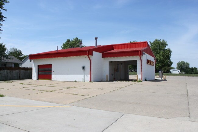
Property Record
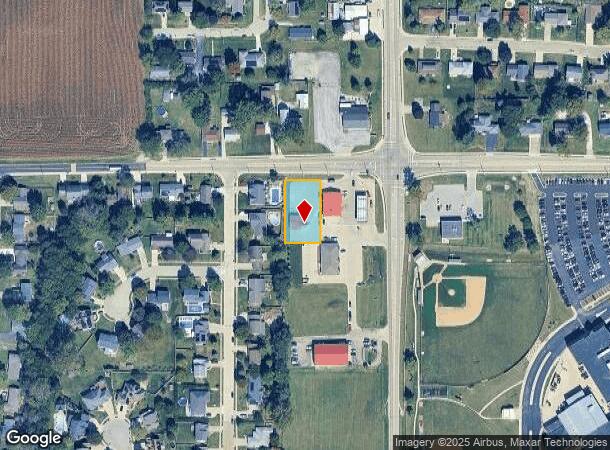
W Legion Hall Rd, Dunlap, IL 61525
NEARBY LISTINGS FOR SALE OR LEASE
Property Detail
W Legion Hall Rd
Peoria, IL
NE 1/4 SEC 15-10N-7E 0.445 AC CAR WASH LEASE LOCATED ON W 105 OF FOLLOWING DESC TRACT: BEG 38.58 W & 30 S OF NE COR SEC 15: TH S 200.03 W 292.27 N 199.94 E 291.53 TO POB (EXC LEGION HALL RD ROW AS DESC PER DOC 13-19895)
08-15-228-034
Peoria
Commercialnec
Illinois
2024
0.45 AC
2024
Outlying Peoria County
003900
Peoria
DEMOGRAPHICS near W Legion Hall Rd
1 Mile
3 Mile
5 Mile
2024 Total Population
1,417
3,682
18,463
2029 Population
1,367
3,564
17,830
Pop Growth 2024-2029
(3.53%)
(3.20%)
(3.43%)
Average Age
38
37
37
2024 Total Households
502
1,260
6,682
HH Growth 2024-2029
(3.59%)
(3.41%)
(3.70%)
Median Household Inc
$104,286
$138,411
$116,015
Avg Household Size
2.80
2.90
2.70
2024 Avg HH Vehicles
2.00
2.00
2.00
Median Home Value
$217,442
$292,881
$283,980
Median Year Built
1975
2001
2000
Nearby Places
Map Layers
Map Styles
 Street
 Aerial
- Restaurants
- Banks
- Shops
- Fitness
- Groceries
PUBLIC TRANSPORTATION
AIRPORT
General Downing - Peoria International
DRIVE
WALK
Distance
General Downing - Peoria International
25 min
15.5 mi
Freight Ports
Port Milwaukee
DRIVE
WALK
Distance
Port Milwaukee
266 min
220.1 mi
SALE & LEASE HISTORY
LISTING DATE
SALE/LEASE

Jun 21, 2018
For Sale
Aug 08, 2018
For Lease
Nearby Properties
Address
Land Use
TOTAL SIZE
Lot Size
Zoning
Address
Land Use
TOTAL SIZE
Lot Size
Zoning
Address
Land Use
TOTAL SIZE
Lot Size
Zoning
0.77 AC
Address
Land Use
TOTAL SIZE
Lot Size
Zoning
7,589 SF
11.18 AC
Address
Land Use
TOTAL SIZE
Lot Size
Zoning
Address
Land Use
TOTAL SIZE
Lot Size
Zoning
12,397 SF
5.23 AC
Address
Land Use
TOTAL SIZE
Lot Size
Zoning
6,534 SF
5.04 AC
Address
Land Use
TOTAL SIZE
Lot Size
Zoning
8,191 SF
25.34 AC
Address
Land Use
TOTAL SIZE
Lot Size
Zoning
3,868 SF
199.70 AC
Address
Land Use
TOTAL SIZE
Lot Size
Zoning
0.86 AC
Address
Land Use
TOTAL SIZE
Lot Size
Zoning
6,056 SF
26.47 AC
Address
Land Use
TOTAL SIZE
Lot Size
Zoning
7,536 SF
30.05 AC
Address
Land Use
TOTAL SIZE
Lot Size
Zoning
7,416 SF
5.15 AC
Address
Land Use
TOTAL SIZE
Lot Size
Zoning
8,038 SF
4.92 AC
Address
Land Use
TOTAL SIZE
Lot Size
Zoning
1.38 AC
Address
Land Use
TOTAL SIZE
Lot Size
Zoning
6,680 SF
39.02 AC
Address
Land Use
TOTAL SIZE
Lot Size
Zoning
5,885 SF
9.41 AC
Address
Land Use
TOTAL SIZE
Lot Size
Zoning
5,070 SF
5.15 AC
Address
Land Use
TOTAL SIZE
Lot Size
Zoning
59.40 AC
Address
Land Use
TOTAL SIZE
Lot Size
Zoning
1.96 AC
Address
Land Use
TOTAL SIZE
Lot Size
Zoning
5,469 SF
12.84 AC
Address
Land Use
TOTAL SIZE
Lot Size
Zoning
2,625 SF
160 AC
Address
Land Use
TOTAL SIZE
Lot Size
Zoning
4,584 SF
118.55 AC
Address
Land Use
TOTAL SIZE
Lot Size
Zoning
4,469 SF
5.17 AC
Address
Land Use
TOTAL SIZE
Lot Size
Zoning
0.52 AC
Address
Land Use
TOTAL SIZE
Lot Size
Zoning
0.43 AC
Address
Land Use
TOTAL SIZE
Lot Size
Zoning
0.67 AC
Address
Land Use
TOTAL SIZE
Lot Size
Zoning
3,356 SF
73.76 AC
Address
Land Use
TOTAL SIZE
Lot Size
Zoning
5,514 SF
78.49 AC
Address
Land Use
TOTAL SIZE
Lot Size
Zoning
6,020 SF
5.75 AC
Address
Land Use
TOTAL SIZE
Lot Size
Zoning
4,367 SF
9.98 AC
The World's #1 Commercial Real Estate Marketplace
Connect with us
© 2025 CoStar Group
The information above has been obtained from sources believed reliable. While we do not doubt its accuracy we have not verified it and make no guarantee, warranty or representation about it. It is your responsibility to independently confirm its accuracy and completeness. Any projections, opinions, assumptions, or estimates used are for example only and do not represent the current or future performance of the property. The value of this transaction to you depends on tax and other factors which should be evaluated by your tax, financial, and legal advisors. You and your advisors should conduct a careful, independent investigation of the property to determine to your satisfaction the suitability of the property for your needs.