Property Record
13822 Highway, Chico, CA 95973
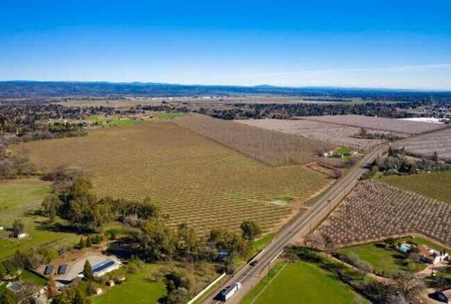

Property Detail
13822 Highway
Chico, CA
13822 HWY 99N
047-260-199-000
BUTTE
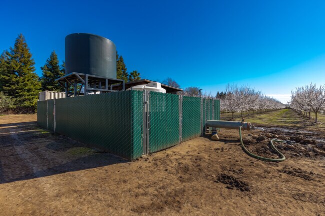
Orchard
California
A Areas with a 1% annual chance of flooding and a 26% chance of flooding over the life of a 30-year mortgage.
44
2024
52.72 AC
2025
Other Market Areas
000201
NEARBY LISTINGS FOR SALE OR LEASE
DEMOGRAPHICS near 13822 Highway
1 mile
3 mile
5 mile
2025 Total Population
1,459
11,346
43,343
2030 Population
1,436
11,321
42,629
Pop Growth 2025-2030
(1.58%)
(0.22%)
(1.65%)
Average Age
43
38
39
2025 Total Households
524
4,241
17,693
HH Growth 2025-2030
(1.53%)
(0.31%)
(1.90%)
Median Household Inc
$113,802
$100,302
$79,284
Avg Household Size
2.80
2.60
2.40
2025 Avg HH Vehicles
3.00
2.00
2.00
Median Home Value
$787,852
$677,774
$475,472
Median Year Built
1988
2001
1985
Nearby Places
Map Layers
Map Styles
 Street
 Aerial
Transit
 Traffic
 Biking
Places
Listings with unknown addresses are not visible on the map
- Restaurants
- Banks
- Shops
- Fitness
- Groceries
PUBLIC TRANSPORTATION
COMMUTER RAIL
Chico Amtrak (Coast Starlight - Amtrak)
Drive
Walk
Distance
Chico Amtrak (Coast Starlight - Amtrak)
12 min
8.4 mi
Freight Ports
Port of Stockton
Drive
Walk
Distance
Port of Stockton
165 min
137.5 mi
SALE & LEASE HISTORY
LISTING DATE
SALE/LEASE

May 13, 2021
For Sale
Nearby Properties
Address
Land Use
TOTAL SIZE
Lot Size
Zoning
Address
Land Use
TOTAL SIZE
Lot Size
Zoning
12.63 AC
R1
Address
Land Use
TOTAL SIZE
Lot Size
Zoning
190,996 SF
7.94 AC
R3
Address
Land Use
TOTAL SIZE
Lot Size
Zoning
8,008 SF
8.79 AC
Address
Land Use
TOTAL SIZE
Lot Size
Zoning
9,784 SF
3.97 AC
R1
Address
Land Use
TOTAL SIZE
Lot Size
Zoning
142,712 SF
7.24 AC
Address
Land Use
TOTAL SIZE
Lot Size
Zoning
132,768 SF
9.65 AC
R3
Address
Land Use
TOTAL SIZE
Lot Size
Zoning
123,494 SF
6.84 AC
R3
Address
Land Use
TOTAL SIZE
Lot Size
Zoning
397,710 SF
18 AC
00
Address
Land Use
TOTAL SIZE
Lot Size
Zoning
25,304 SF
5.41 AC
CC
Address
Land Use
TOTAL SIZE
Lot Size
Zoning
29,131 SF
4.42 AC
AM
Address
Land Use
TOTAL SIZE
Lot Size
Zoning
65.23 AC
A40
Address
Land Use
TOTAL SIZE
Lot Size
Zoning
68,704 SF
2.29 AC
Address
Land Use
TOTAL SIZE
Lot Size
Zoning
40,269 SF
1.97 AC
CN
Address
Land Use
TOTAL SIZE
Lot Size
Zoning
41,756 SF
3.66 AC
Address
Land Use
TOTAL SIZE
Lot Size
Zoning
2.38 AC
Address
Land Use
TOTAL SIZE
Lot Size
Zoning
20,000 SF
5.61 AC
Address
Land Use
TOTAL SIZE
Lot Size
Zoning
10 AC
C2
Address
Land Use
TOTAL SIZE
Lot Size
Zoning
63,674 SF
4.58 AC
Address
Land Use
TOTAL SIZE
Lot Size
Zoning
153,600 SF
8.77 AC
Address
Land Use
TOTAL SIZE
Lot Size
Zoning
22,320 SF
1.26 AC
CN
Address
Land Use
TOTAL SIZE
Lot Size
Zoning
7,000 SF
0.99 AC
CN
Address
Land Use
TOTAL SIZE
Lot Size
Zoning
8,801 SF
24.35 AC
Address
Land Use
TOTAL SIZE
Lot Size
Zoning
41,720 SF
3 AC
Address
Land Use
TOTAL SIZE
Lot Size
Zoning
15,672 SF
1.68 AC
C2
Address
Land Use
TOTAL SIZE
Lot Size
Zoning
29,194 SF
2.92 AC
OC
Address
Land Use
TOTAL SIZE
Lot Size
Zoning
15,944 SF
1.33 AC
Address
Land Use
TOTAL SIZE
Lot Size
Zoning
1,008 SF
178.21 AC
Address
Land Use
TOTAL SIZE
Lot Size
Zoning
15,048 SF
1.64 AC
Address
Land Use
TOTAL SIZE
Lot Size
Zoning
42,379 SF
3.65 AC
Address
Land Use
TOTAL SIZE
Lot Size
Zoning
22,320 SF
1.63 AC
The World's #1 Commercial Real Estate Marketplace
Connect with us
© 2026 CoStar Group
The information above has been obtained from sources believed reliable. While we do not doubt its accuracy we have not verified it and make no guarantee, warranty or representation about it. It is your responsibility to independently confirm its accuracy and completeness. Any projections, opinions, assumptions, or estimates used are for example only and do not represent the current or future performance of the property. The value of this transaction to you depends on tax and other factors which should be evaluated by your tax, financial, and legal advisors. You and your advisors should conduct a careful, independent investigation of the property to determine to your satisfaction the suitability of the property for your needs.