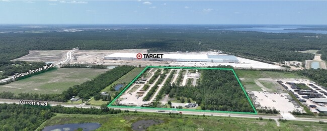
Property Record
13833 Garrett Rd, Houston, TX 77044
NEARBY LISTINGS FOR SALE OR LEASE
-
-
View all Houston listings for lease on LoopNet.com
Property Detail
13833 Garrett Rd
Houston-The Woodlands-Sugar Land, TX
Lincoln Park Farms
0502060000007
LT 7 BLK C LINCOLN PARK FARMS
Commercialnec
Harris
X
Texas
48201C0520L
7
2024
15.19 AC
2025
Northeast Hwy 90
252002
Houston
DEMOGRAPHICS near 13833 Garrett Rd
1 Mile
3 Mile
5 Mile
2024 Total Population
304
30,928
87,521
2029 Population
314
31,524
90,878
Pop Growth 2024-2029
+ 3.29%
+ 1.93%
+ 3.84%
Average Age
33
32
33
2024 Total Households
92
9,077
26,791
HH Growth 2024-2029
+ 3.26%
+ 1.86%
+ 3.83%
Median Household Inc
$55,000
$73,720
$72,796
Avg Household Size
3.40
3.40
3.20
2024 Avg HH Vehicles
2.00
2.00
2.00
Median Home Value
$212,000
$199,249
$216,583
Median Year Built
2009
2008
2008
Nearby Places
Map Layers
Map Styles
 Street
 Aerial
- Restaurants
- Banks
- Shops
- Fitness
- Groceries
PUBLIC TRANSPORTATION
AIRPORT
George Bush Intcntl/Houston
DRIVE
WALK
Distance
George Bush Intcntl/Houston
22 min
16.1 mi
William P Hobby
DRIVE
WALK
Distance
William P Hobby
42 min
24.0 mi
Freight Ports
Port of Houston
DRIVE
WALK
Distance
Port of Houston
29 min
16.0 mi
SALE & LEASE HISTORY
LISTING DATE
SALE/LEASE

Dec 21, 2023
For Lease
Nearby Properties
Address
Land Use
TOTAL SIZE
Lot Size
Zoning
Address
Land Use
TOTAL SIZE
Lot Size
Zoning
1,421,980 SF
147.83 AC
Address
Land Use
TOTAL SIZE
Lot Size
Zoning
1,036,748 SF
72.42 AC
Address
Land Use
TOTAL SIZE
Lot Size
Zoning
1,793.99 AC
Address
Land Use
TOTAL SIZE
Lot Size
Zoning
434,978 SF
37.08 AC
Address
Land Use
TOTAL SIZE
Lot Size
Zoning
425,356 SF
4.65 AC
Address
Land Use
TOTAL SIZE
Lot Size
Zoning
284,203 SF
12.73 AC
Address
Land Use
TOTAL SIZE
Lot Size
Zoning
315,000 SF
21.47 AC
Address
Land Use
TOTAL SIZE
Lot Size
Zoning
212,558 SF
52.87 AC
Address
Land Use
TOTAL SIZE
Lot Size
Zoning
824,156 SF
53.31 AC
Address
Land Use
TOTAL SIZE
Lot Size
Zoning
214,100 SF
11.32 AC
Address
Land Use
TOTAL SIZE
Lot Size
Zoning
260,792 SF
206.39 AC
Address
Land Use
TOTAL SIZE
Lot Size
Zoning
80,653 SF
60.20 AC
Address
Land Use
TOTAL SIZE
Lot Size
Zoning
186,488 SF
4.57 AC
Address
Land Use
TOTAL SIZE
Lot Size
Zoning
131,500 SF
6.22 AC
Address
Land Use
TOTAL SIZE
Lot Size
Zoning
210.19 AC
Address
Land Use
TOTAL SIZE
Lot Size
Zoning
102,045 SF
14.11 AC
Address
Land Use
TOTAL SIZE
Lot Size
Zoning
92,064 SF
0.87 AC
Address
Land Use
TOTAL SIZE
Lot Size
Zoning
239,419 SF
33 AC
Address
Land Use
TOTAL SIZE
Lot Size
Zoning
66,450 SF
18 AC
Address
Land Use
TOTAL SIZE
Lot Size
Zoning
266,076 SF
7.92 AC
Address
Land Use
TOTAL SIZE
Lot Size
Zoning
4,720 SF
25 AC
Address
Land Use
TOTAL SIZE
Lot Size
Zoning
107,772 SF
11.60 AC
Address
Land Use
TOTAL SIZE
Lot Size
Zoning
139,752 SF
20.41 AC
Address
Land Use
TOTAL SIZE
Lot Size
Zoning
98,733 SF
7.94 AC
Address
Land Use
TOTAL SIZE
Lot Size
Zoning
171.95 AC
Address
Land Use
TOTAL SIZE
Lot Size
Zoning
135,354 SF
40 AC
Address
Land Use
TOTAL SIZE
Lot Size
Zoning
128,496 SF
10.19 AC
Address
Land Use
TOTAL SIZE
Lot Size
Zoning
79.45 AC
Address
Land Use
TOTAL SIZE
Lot Size
Zoning
112,872 SF
49.10 AC
Address
Land Use
TOTAL SIZE
Lot Size
Zoning
23,840 SF
103.67 AC
The World's #1 Commercial Real Estate Marketplace
Connect with us
© 2025 CoStar Group
The information above has been obtained from sources believed reliable. While we do not doubt its accuracy we have not verified it and make no guarantee, warranty or representation about it. It is your responsibility to independently confirm its accuracy and completeness. Any projections, opinions, assumptions, or estimates used are for example only and do not represent the current or future performance of the property. The value of this transaction to you depends on tax and other factors which should be evaluated by your tax, financial, and legal advisors. You and your advisors should conduct a careful, independent investigation of the property to determine to your satisfaction the suitability of the property for your needs.