Property Record
13837 N Vision Dr, Kenton, OH 43326

NEARBY LISTINGS FOR SALE OR LEASE
Property Detail
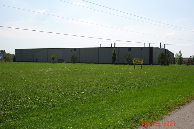
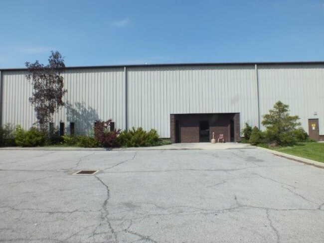
13837 N Vision Dr
Manufacturinglight
Vms No 10663 10267&10438
X
10663 10267 5.001A
39065C0350D
Hardin
2024
Ohio
2024
5 AC
000700
Other Market Areas
50,000 SF
04-100047.0000
DEMOGRAPHICS near 13837 N Vision Dr
1 Mile
3 Mile
5 Mile
2024 Total Population
135
7,700
10,862
2029 Population
132
7,727
10,862
Pop Growth 2024-2029
(2.22%)
+ 0.35%
0.00%
Average Age
41
40
40
2024 Total Households
51
3,120
4,432
HH Growth 2024-2029
(1.96%)
+ 0.26%
(0.05%)
Median Household Inc
$67,500
$44,001
$44,992
Avg Household Size
2.60
2.40
2.30
2024 Avg HH Vehicles
3.00
2.00
2.00
Median Home Value
$184,615
$89,936
$113,375
Median Year Built
1969
1957
1962
Nearby Places
Map Layers
Map Styles
 Street
 Aerial
- Restaurants
- Banks
- Shops
- Fitness
- Groceries
SALE & LEASE HISTORY
LISTING DATE
SALE/LEASE

May 12, 2017
For Sale
Nearby Properties
Address
Land Use
TOTAL SIZE
Lot Size
Zoning
Address
Land Use
TOTAL SIZE
Lot Size
Zoning
56,300 SF
30.78 AC
Address
Land Use
TOTAL SIZE
Lot Size
Zoning
99,440 SF
45.84 AC
Address
Land Use
TOTAL SIZE
Lot Size
Zoning
4.60 AC
Address
Land Use
TOTAL SIZE
Lot Size
Zoning
88,774 SF
54.63 AC
Address
Land Use
TOTAL SIZE
Lot Size
Zoning
92,578 SF
4.69 AC
Address
Land Use
TOTAL SIZE
Lot Size
Zoning
9,272 SF
10.77 AC
Address
Land Use
TOTAL SIZE
Lot Size
Zoning
51,727 SF
10.47 AC
Address
Land Use
TOTAL SIZE
Lot Size
Zoning
71,470 SF
10.31 AC
Address
Land Use
TOTAL SIZE
Lot Size
Zoning
46,560 SF
6.29 AC
Address
Land Use
TOTAL SIZE
Lot Size
Zoning
1,080 SF
159.46 AC
Address
Land Use
TOTAL SIZE
Lot Size
Zoning
2,108 SF
1,015.27 AC
Address
Land Use
TOTAL SIZE
Lot Size
Zoning
50,220 SF
1.81 AC
Address
Land Use
TOTAL SIZE
Lot Size
Zoning
55.07 AC
Address
Land Use
TOTAL SIZE
Lot Size
Zoning
80,000 SF
9.81 AC
Address
Land Use
TOTAL SIZE
Lot Size
Zoning
19,656 SF
17 AC
Address
Land Use
TOTAL SIZE
Lot Size
Zoning
32,304 SF
6 AC
Address
Land Use
TOTAL SIZE
Lot Size
Zoning
37,414 SF
2.93 AC
Address
Land Use
TOTAL SIZE
Lot Size
Zoning
6,480 SF
3 AC
Address
Land Use
TOTAL SIZE
Lot Size
Zoning
9,602 SF
16.04 AC
Address
Land Use
TOTAL SIZE
Lot Size
Zoning
6,600 SF
Address
Land Use
TOTAL SIZE
Lot Size
Zoning
14,866 SF
3.06 AC
Address
Land Use
TOTAL SIZE
Lot Size
Zoning
75,337 SF
14.02 AC
Address
Land Use
TOTAL SIZE
Lot Size
Zoning
1,200 SF
45.41 AC
Address
Land Use
TOTAL SIZE
Lot Size
Zoning
23,565 SF
0.40 AC
Address
Land Use
TOTAL SIZE
Lot Size
Zoning
6,924 SF
0.25 AC
Address
Land Use
TOTAL SIZE
Lot Size
Zoning
4,320 SF
10.75 AC
Address
Land Use
TOTAL SIZE
Lot Size
Zoning
10,000 SF
15.80 AC
Address
Land Use
TOTAL SIZE
Lot Size
Zoning
8,496 SF
5.34 AC
Address
Land Use
TOTAL SIZE
Lot Size
Zoning
0.08 AC
The World's #1 Commercial Real Estate Marketplace
Connect with us
© 2026 CoStar Group
The information above has been obtained from sources believed reliable. While we do not doubt its accuracy we have not verified it and make no guarantee, warranty or representation about it. It is your responsibility to independently confirm its accuracy and completeness. Any projections, opinions, assumptions, or estimates used are for example only and do not represent the current or future performance of the property. The value of this transaction to you depends on tax and other factors which should be evaluated by your tax, financial, and legal advisors. You and your advisors should conduct a careful, independent investigation of the property to determine to your satisfaction the suitability of the property for your needs.