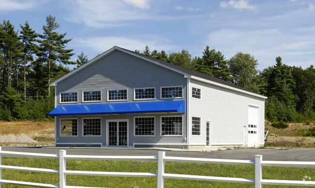
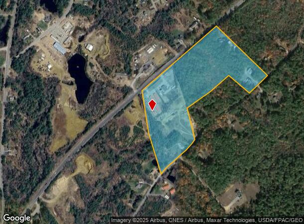
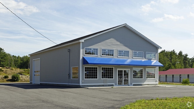
Property Record
1320 Carl Broggi Hwy, Lebanon, ME 04027
NEARBY LISTINGS FOR SALE OR LEASE
-
-
View all Lebanon listings for sale on LoopNet.com
Property Detail
1320 Carl Broggi Hwy
LBNN-000003R-000000-000005
York
Residentialacreage
Maine
X
5
23031C0506G
7.56 AC
2024
York County
2024
Portland/South Portland
031000
Portland-South Portland, ME
DEMOGRAPHICS near 1320 Carl Broggi Hwy
1 Mile
3 Mile
5 Mile
2024 Total Population
613
8,418
28,103
2029 Population
635
8,782
29,331
Pop Growth 2024-2029
+ 3.59%
+ 4.32%
+ 4.37%
Average Age
41
43
42
2024 Total Households
230
3,421
11,628
HH Growth 2024-2029
+ 3.48%
+ 4.33%
+ 4.42%
Median Household Inc
$68,437
$75,929
$82,295
Avg Household Size
2.60
2.40
2.40
2024 Avg HH Vehicles
2.00
2.00
2.00
Median Home Value
$233,333
$228,033
$242,949
Median Year Built
1984
1983
1977
Nearby Places
- Restaurants
- Banks
- Shops
- Fitness
- Groceries
PUBLIC TRANSPORTATION
AIRPORT
Portsmouth International at Pease
DRIVE
WALK
Distance
Portsmouth International at Pease
40 min
24.1 mi
Freight Ports
Portland, ME
DRIVE
WALK
Distance
Portland, ME
61 min
45.3 mi
Nearby Properties
Address
Land Use
TOTAL SIZE
Lot Size
Zoning
Address
Land Use
TOTAL SIZE
Lot Size
Zoning
111,807 SF
31.93 AC
HC
Address
Land Use
TOTAL SIZE
Lot Size
Zoning
221,995 SF
35.47 AC
IND
Address
Land Use
TOTAL SIZE
Lot Size
Zoning
53,517 SF
30 AC
A
Address
Land Use
TOTAL SIZE
Lot Size
Zoning
114,452 SF
5.81 AC
NMU
Address
Land Use
TOTAL SIZE
Lot Size
Zoning
87.64 AC
A
Address
Land Use
TOTAL SIZE
Lot Size
Zoning
30 AC
RA
Address
Land Use
TOTAL SIZE
Lot Size
Zoning
1,968 SF
53 AC
RA
Address
Land Use
TOTAL SIZE
Lot Size
Zoning
23,344 SF
5.30 AC
NMU
Address
Land Use
TOTAL SIZE
Lot Size
Zoning
2.60 AC
RA
Address
Land Use
TOTAL SIZE
Lot Size
Zoning
37,884 SF
3.49 AC
R2
Address
Land Use
TOTAL SIZE
Lot Size
Zoning
32 AC
RA
Address
Land Use
TOTAL SIZE
Lot Size
Zoning
4,756 SF
1.27 AC
HC
Address
Land Use
TOTAL SIZE
Lot Size
Zoning
0.82 AC
R1
Address
Land Use
TOTAL SIZE
Lot Size
Zoning
112,089 SF
16.33 AC
IND
Address
Land Use
TOTAL SIZE
Lot Size
Zoning
3,703 SF
15.60 AC
A
Address
Land Use
TOTAL SIZE
Lot Size
Zoning
18,666 SF
5.80 AC
R1
Address
Land Use
TOTAL SIZE
Lot Size
Zoning
5,138 SF
1.53 AC
HC
Address
Land Use
TOTAL SIZE
Lot Size
Zoning
14,576 SF
1.96 AC
HC
Address
Land Use
TOTAL SIZE
Lot Size
Zoning
15.40 AC
RA
Address
Land Use
TOTAL SIZE
Lot Size
Zoning
6.70 AC
A
Address
Land Use
TOTAL SIZE
Lot Size
Zoning
1,850 SF
1.44 AC
HC
Address
Land Use
TOTAL SIZE
Lot Size
Zoning
7.40 AC
IND
Address
Land Use
TOTAL SIZE
Lot Size
Zoning
8,000 SF
87.94 AC
R3
Address
Land Use
TOTAL SIZE
Lot Size
Zoning
1,668 SF
2 AC
RA
Address
Land Use
TOTAL SIZE
Lot Size
Zoning
7,338 SF
0.45 AC
R2
Address
Land Use
TOTAL SIZE
Lot Size
Zoning
8,679 SF
3.50 AC
R1
Address
Land Use
TOTAL SIZE
Lot Size
Zoning
0.50 AC
IND
Address
Land Use
TOTAL SIZE
Lot Size
Zoning
5,718 SF
0.67 AC
R2
Address
Land Use
TOTAL SIZE
Lot Size
Zoning
3,400 SF
0.39 AC
NMU
Address
Land Use
TOTAL SIZE
Lot Size
Zoning
8,473 SF
0.49 AC
NMU
The World's #1 Commercial Real Estate Marketplace
Connect with us
© 2025 CoStar Group
The information above has been obtained from sources believed reliable. While we do not doubt its accuracy we have not verified it and make no guarantee, warranty or representation about it. It is your responsibility to independently confirm its accuracy and completeness. Any projections, opinions, assumptions, or estimates used are for example only and do not represent the current or future performance of the property. The value of this transaction to you depends on tax and other factors which should be evaluated by your tax, financial, and legal advisors. You and your advisors should conduct a careful, independent investigation of the property to determine to your satisfaction the suitability of the property for your needs.