Property Record
1385 1St St N, Alabaster, AL 35007
NEARBY LISTINGS FOR SALE OR LEASE
Property Detail
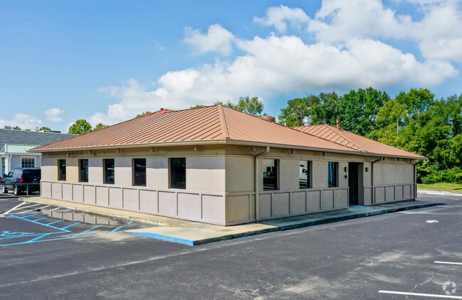
1385 1St St N
13-7-25-3-001-008-007
COM @ INT OF W R/W HWY 31 & S BDRY OF SEC36 T20S R3W TH NELYALG SD R/W 675 TO POB TH NWLY 210 TH NELY 100' TH SELY 210' TH SWLY 100' TO POB
Restaurantbuilding
Shelby
AE
Alabama
01117C0214E
0.48 AC
2024
I-65 Corr/S Shelby County
2024
Birmingham
030341
Birmingham-Hoover, AL
2,984 SF
DEMOGRAPHICS near 1385 1St St N
1 Mile
3 Mile
5 Mile
2024 Total Population
6,704
37,253
71,340
2029 Population
7,219
40,151
77,559
Pop Growth 2024-2029
+ 7.68%
+ 7.78%
+ 8.72%
Average Age
39
39
39
2024 Total Households
2,486
13,763
25,849
HH Growth 2024-2029
+ 7.84%
+ 7.96%
+ 8.82%
Median Household Inc
$77,266
$84,097
$83,867
Avg Household Size
2.60
2.60
2.70
2024 Avg HH Vehicles
2.00
2.00
2.00
Median Home Value
$200,279
$219,966
$236,759
Median Year Built
1994
1993
1995
Nearby Places
Map Layers
Map Styles
 Street
 Aerial
- Restaurants
- Banks
- Shops
- Fitness
- Groceries
PUBLIC TRANSPORTATION
AIRPORT
Birmingham-Shuttlesworth International
DRIVE
WALK
Distance
Birmingham-Shuttlesworth International
36 min
26.4 mi
Freight Ports
Port of Mobile
DRIVE
WALK
Distance
Port of Mobile
257 min
236.1 mi
SALE & LEASE HISTORY
LISTING DATE
SALE/LEASE

Sep 29, 2016
For Sale
Sep 29, 2016
For Lease
Oct 15, 2019
For Lease
Nov 16, 2017
For Sale
Aug 23, 2019
For Sale
Nearby Properties
Address
Land Use
TOTAL SIZE
Lot Size
Zoning
Address
Land Use
TOTAL SIZE
Lot Size
Zoning
228,107 SF
12 AC
Address
Land Use
TOTAL SIZE
Lot Size
Zoning
2,100 SF
6.50 AC
Address
Land Use
TOTAL SIZE
Lot Size
Zoning
5,574 SF
14.87 AC
Address
Land Use
TOTAL SIZE
Lot Size
Zoning
2,891 SF
18.10 AC
Address
Land Use
TOTAL SIZE
Lot Size
Zoning
3,872 SF
20.35 AC
Address
Land Use
TOTAL SIZE
Lot Size
Zoning
9,444 SF
21.79 AC
Address
Land Use
TOTAL SIZE
Lot Size
Zoning
10,500 SF
21 AC
Address
Land Use
TOTAL SIZE
Lot Size
Zoning
1,763 SF
21.99 AC
Address
Land Use
TOTAL SIZE
Lot Size
Zoning
11,192 SF
26.78 AC
Address
Land Use
TOTAL SIZE
Lot Size
Zoning
226,790 SF
40 AC
Address
Land Use
TOTAL SIZE
Lot Size
Zoning
118,303 SF
22.89 AC
Address
Land Use
TOTAL SIZE
Lot Size
Zoning
219,975 SF
14.90 AC
Address
Land Use
TOTAL SIZE
Lot Size
Zoning
268,750 SF
9.93 AC
Address
Land Use
TOTAL SIZE
Lot Size
Zoning
62,398 SF
11.51 AC
Address
Land Use
TOTAL SIZE
Lot Size
Zoning
84,355 SF
15.65 AC
Address
Land Use
TOTAL SIZE
Lot Size
Zoning
43,419 SF
7.81 AC
Address
Land Use
TOTAL SIZE
Lot Size
Zoning
126,897 SF
9.43 AC
Address
Land Use
TOTAL SIZE
Lot Size
Zoning
73,327 SF
9.76 AC
Address
Land Use
TOTAL SIZE
Lot Size
Zoning
46,031 SF
9.86 AC
Address
Land Use
TOTAL SIZE
Lot Size
Zoning
6,864 SF
6.11 AC
Address
Land Use
TOTAL SIZE
Lot Size
Zoning
30,158 SF
8.35 AC
Address
Land Use
TOTAL SIZE
Lot Size
Zoning
137,068 SF
9.08 AC
Address
Land Use
TOTAL SIZE
Lot Size
Zoning
54,297 SF
41 AC
Address
Land Use
TOTAL SIZE
Lot Size
Zoning
3,414 SF
7.03 AC
Address
Land Use
TOTAL SIZE
Lot Size
Zoning
77,365 SF
24.97 AC
Address
Land Use
TOTAL SIZE
Lot Size
Zoning
Address
Land Use
TOTAL SIZE
Lot Size
Zoning
94,901 SF
10.78 AC
Address
Land Use
TOTAL SIZE
Lot Size
Zoning
51,264 SF
6.98 AC
The World's #1 Commercial Real Estate Marketplace
Connect with us
© 2025 CoStar Group
The information above has been obtained from sources believed reliable. While we do not doubt its accuracy we have not verified it and make no guarantee, warranty or representation about it. It is your responsibility to independently confirm its accuracy and completeness. Any projections, opinions, assumptions, or estimates used are for example only and do not represent the current or future performance of the property. The value of this transaction to you depends on tax and other factors which should be evaluated by your tax, financial, and legal advisors. You and your advisors should conduct a careful, independent investigation of the property to determine to your satisfaction the suitability of the property for your needs.