Property Record
1385 8Th St, Arcata, CA 95521
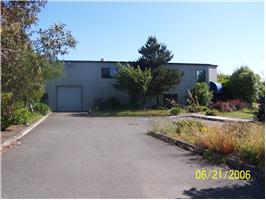

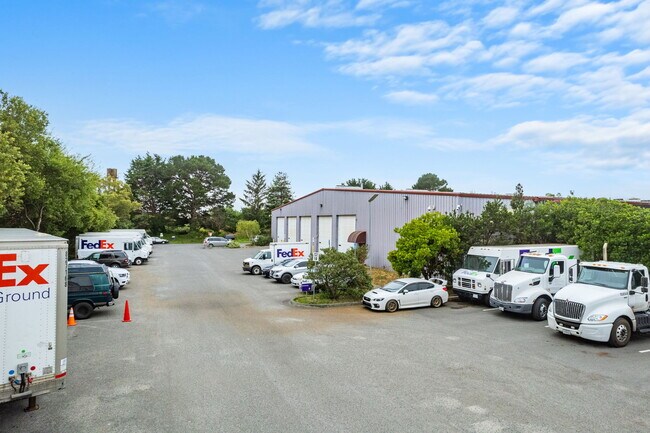
Property Detail
1385 8Th St
Eureka-Arcata, CA
SUB: 2442, PARCEL MAP PLAT BOOK: P21 PLAT PAGE: 129 LOT: 2
021-174-012-000
Humboldt
Lightindustrial
California
I-C
2
B and X Area of moderate flood hazard, usually the area between the limits of the 100-year and 500-year floods.
3.56 AC
2024
Eureka/Crescent City
2025
Other Market Areas
001103
NEARBY LISTINGS FOR SALE OR LEASE
DEMOGRAPHICS near 1385 8Th St
1 mile
3 mile
5 mile
2024 Total Population
9,907
21,487
32,447
2029 Population
9,875
21,351
32,102
Pop Growth 2024-2029
(0.32%)
(0.63%)
(1.06%)
Average Age
34
36
38
2024 Total Households
4,086
9,036
13,580
HH Growth 2024-2029
(0.20%)
(0.56%)
(1.06%)
Median Household Inc
$54,754
$52,123
$60,351
Avg Household Size
2.10
2.10
2.20
2024 Avg HH Vehicles
2.00
2.00
2.00
Median Home Value
$492,597
$491,903
$530,926
Median Year Built
1973
1976
1978
Nearby Places
Map Layers
Map Styles
 Street
 Aerial
Transit
 Traffic
 Biking
Places
Listings with unknown addresses are not visible on the map
- Restaurants
- Banks
- Shops
- Fitness
- Groceries
PUBLIC TRANSPORTATION
AIRPORT
California Redwood Coast-Humboldt County
Drive
Walk
Distance
California Redwood Coast-Humboldt County
16 min
9.2 mi
Freight Ports
Port of Coos Bay, OR
Drive
Walk
Distance
Port of Coos Bay, OR
283 min
209.2 mi
Nearby Properties
Address
Land Use
TOTAL SIZE
Lot Size
Zoning
Address
Land Use
TOTAL SIZE
Lot Size
Zoning
1,304 SF
34 AC
PF
Address
Land Use
TOTAL SIZE
Lot Size
Zoning
7.38 AC
AE
Address
Land Use
TOTAL SIZE
Lot Size
Zoning
9 AC
PF
Address
Land Use
TOTAL SIZE
Lot Size
Zoning
2.55 AC
RM
Address
Land Use
TOTAL SIZE
Lot Size
Zoning
0.73 AC
RM-2500-AR
Address
Land Use
TOTAL SIZE
Lot Size
Zoning
1.43 AC
IL
Address
Land Use
TOTAL SIZE
Lot Size
Zoning
8.17 AC
CG
Address
Land Use
TOTAL SIZE
Lot Size
Zoning
51,763 SF
0.68 AC
Address
Land Use
TOTAL SIZE
Lot Size
Zoning
3.56 AC
RM
Address
Land Use
TOTAL SIZE
Lot Size
Zoning
2,128 SF
3.90 AC
R-MH
Address
Land Use
TOTAL SIZE
Lot Size
Zoning
18,488 SF
1.71 AC
CVS
Address
Land Use
TOTAL SIZE
Lot Size
Zoning
4.18 AC
Address
Land Use
TOTAL SIZE
Lot Size
Zoning
1.89 AC
CG
Address
Land Use
TOTAL SIZE
Lot Size
Zoning
2.05 AC
CVS
Address
Land Use
TOTAL SIZE
Lot Size
Zoning
53,340 SF
5.60 AC
RH
Address
Land Use
TOTAL SIZE
Lot Size
Zoning
5.87 AC
RH
Address
Land Use
TOTAL SIZE
Lot Size
Zoning
2.79 AC
RH
Address
Land Use
TOTAL SIZE
Lot Size
Zoning
1.25 AC
CC
Address
Land Use
TOTAL SIZE
Lot Size
Zoning
2.71 AC
RM
Address
Land Use
TOTAL SIZE
Lot Size
Zoning
Address
Land Use
TOTAL SIZE
Lot Size
Zoning
9,600 SF
4.64 AC
IL
Address
Land Use
TOTAL SIZE
Lot Size
Zoning
2.98 AC
R-MH
Address
Land Use
TOTAL SIZE
Lot Size
Zoning
1.93 AC
C-G
Address
Land Use
TOTAL SIZE
Lot Size
Zoning
1.83 AC
CVS
Address
Land Use
TOTAL SIZE
Lot Size
Zoning
7.27 AC
RH
Address
Land Use
TOTAL SIZE
Lot Size
Zoning
65,556 SF
2.43 AC
R-MH
Address
Land Use
TOTAL SIZE
Lot Size
Zoning
1.68 AC
PF
Address
Land Use
TOTAL SIZE
Lot Size
Zoning
2.99 AC
RM
The World's #1 Commercial Real Estate Marketplace
Connect with us
© 2026 CoStar Group
The information above has been obtained from sources believed reliable. While we do not doubt its accuracy we have not verified it and make no guarantee, warranty or representation about it. It is your responsibility to independently confirm its accuracy and completeness. Any projections, opinions, assumptions, or estimates used are for example only and do not represent the current or future performance of the property. The value of this transaction to you depends on tax and other factors which should be evaluated by your tax, financial, and legal advisors. You and your advisors should conduct a careful, independent investigation of the property to determine to your satisfaction the suitability of the property for your needs.