Property Record
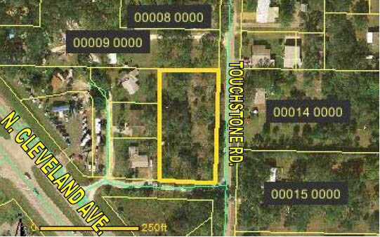
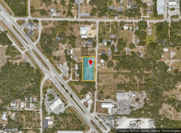
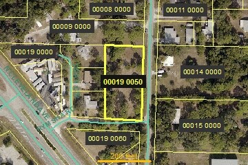
1385 Touchstone Rd, North Fort Myers, FL 33903
NEARBY LISTINGS FOR SALE OR LEASE
Property Detail
1385 Touchstone Rd
Cape Coral-Fort Myers, FL
New 41
03-44-24-00-00019.0050
Lee
Mobilemanufacturedhomeregardlessoflandownership
Florida
AE
0.93 AC
12071C0267G
North Ft Myers
864 SF
Southwest Florida
DEMOGRAPHICS near 1385 Touchstone Rd
1 Mile
3 Mile
5 Mile
2024 Total Population
5,617
51,044
146,339
2029 Population
6,658
60,589
173,139
Pop Growth 2024-2029
+ 18.53%
+ 18.70%
+ 18.31%
Average Age
45
50
44
2024 Total Households
2,544
24,336
59,856
HH Growth 2024-2029
+ 17.96%
+ 18.42%
+ 17.94%
Median Household Inc
$52,093
$45,786
$51,791
Avg Household Size
2.10
2.00
2.30
2024 Avg HH Vehicles
2.00
1.00
2.00
Median Home Value
$162,631
$166,526
$207,480
Median Year Built
1978
1984
1986
Nearby Places
- Restaurants
- Banks
- Shops
- Fitness
- Groceries
PUBLIC TRANSPORTATION
AIRPORT
Southwest Florida International
DRIVE
WALK
Distance
Southwest Florida International
28 min
16.6 mi
Punta Gorda
DRIVE
WALK
Distance
Punta Gorda
29 min
20.7 mi
Freight Ports
Port Manatee
DRIVE
WALK
Distance
Port Manatee
109 min
92.4 mi
Nearby Properties
Address
Land Use
TOTAL SIZE
Lot Size
Zoning
Address
Land Use
TOTAL SIZE
Lot Size
Zoning
770,753 SF
5.87 AC
PUD
Address
Land Use
TOTAL SIZE
Lot Size
Zoning
4.48 AC
U-CTR
Address
Land Use
TOTAL SIZE
Lot Size
Zoning
214,515 SF
30.60 AC
I-1
Address
Land Use
TOTAL SIZE
Lot Size
Zoning
485,271 SF
20.05 AC
CORR
Address
Land Use
TOTAL SIZE
Lot Size
Zoning
646,502 SF
6.11 AC
PUD
Address
Land Use
TOTAL SIZE
Lot Size
Zoning
552,157 SF
4.20 AC
PUD
Address
Land Use
TOTAL SIZE
Lot Size
Zoning
347,871 SF
29.40 AC
RML
Address
Land Use
TOTAL SIZE
Lot Size
Zoning
723,322 SF
1.73 AC
PUD
Address
Land Use
TOTAL SIZE
Lot Size
Zoning
13.60 AC
CC
Address
Land Use
TOTAL SIZE
Lot Size
Zoning
243,841 SF
3.17 AC
CIVIC
Address
Land Use
TOTAL SIZE
Lot Size
Zoning
163,618 SF
1.32 AC
CIVIC
Address
Land Use
TOTAL SIZE
Lot Size
Zoning
551,003 SF
3.24 AC
PUD
Address
Land Use
TOTAL SIZE
Lot Size
Zoning
333,938 SF
35.80 AC
C-1
Address
Land Use
TOTAL SIZE
Lot Size
Zoning
61,844 SF
7.31 AC
CC
Address
Land Use
TOTAL SIZE
Lot Size
Zoning
107,306 SF
1.91 AC
CIVIC
Address
Land Use
TOTAL SIZE
Lot Size
Zoning
305,410 SF
1.38 AC
U-CTR
Address
Land Use
TOTAL SIZE
Lot Size
Zoning
138,476 SF
4.11 AC
CORR
Address
Land Use
TOTAL SIZE
Lot Size
Zoning
451,348 SF
21.43 AC
CPD
Address
Land Use
TOTAL SIZE
Lot Size
Zoning
76,154 SF
2.88 AC
U-CTR
Address
Land Use
TOTAL SIZE
Lot Size
Zoning
209,881 SF
63.03 AC
AG-2
Address
Land Use
TOTAL SIZE
Lot Size
Zoning
115,004 SF
1.91 AC
CIVIC
Address
Land Use
TOTAL SIZE
Lot Size
Zoning
124,182 SF
13.30 AC
CORR
Address
Land Use
TOTAL SIZE
Lot Size
Zoning
93,758 SF
1.72 AC
CIVIC
Address
Land Use
TOTAL SIZE
Lot Size
Zoning
124,101 SF
11.60 AC
C-1
Address
Land Use
TOTAL SIZE
Lot Size
Zoning
182,503 SF
1.34 AC
CIVIC
Address
Land Use
TOTAL SIZE
Lot Size
Zoning
151,620 SF
19.97 AC
RM-2
Address
Land Use
TOTAL SIZE
Lot Size
Zoning
76,042 SF
7.50 AC
CORR
Address
Land Use
TOTAL SIZE
Lot Size
Zoning
82,478 SF
15.46 AC
CORR
Address
Land Use
TOTAL SIZE
Lot Size
Zoning
227,527 SF
0.95 AC
CIVIC
Address
Land Use
TOTAL SIZE
Lot Size
Zoning
3,585 SF
2.16 AC
U-CTR
The World's #1 Commercial Real Estate Marketplace
Connect with us
© 2025 CoStar Group
The information above has been obtained from sources believed reliable. While we do not doubt its accuracy we have not verified it and make no guarantee, warranty or representation about it. It is your responsibility to independently confirm its accuracy and completeness. Any projections, opinions, assumptions, or estimates used are for example only and do not represent the current or future performance of the property. The value of this transaction to you depends on tax and other factors which should be evaluated by your tax, financial, and legal advisors. You and your advisors should conduct a careful, independent investigation of the property to determine to your satisfaction the suitability of the property for your needs.