Property Record
13871 S 2700 W, Bluffdale, UT 84065
Current Lease Availabilities
NEARBY LISTINGS FOR SALE OR LEASE
Property Detail
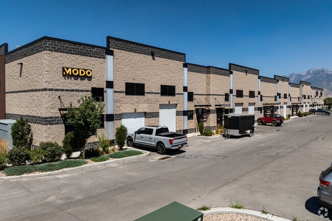
13871 S 2700 W
Salt Lake City, UT
Hobby Caves Condo
33-04-404-001-0000
BEG S 00^2001 W 566.22 FT & E 44.01 FT FR CTR SEC 4, T4S, R1W, SLM; S 89^40 E 629.06 FT; N 0^0221 W 282.99 FT; S 89^40 E 475.81 FT; SWLY ALG 588.01 FT RADIUS CURVE TO L, 145.27 FT (CHD S 11^4331 W); S 4^3850 W 141.34 FT; S 4^3848 W 37.80 FT; S 6^1006
Industrialgeneral
Salt Lake
0
Utah
2025
2.25 AC
112826
Riverton
58,048 SF
Salt Lake City
DEMOGRAPHICS near 13871 S 2700 W
1 Mile
3 Mile
5 Mile
2024 Total Population
7,607
75,427
210,732
2029 Population
7,625
76,968
215,810
Pop Growth 2024-2029
+ 0.24%
+ 2.04%
+ 2.41%
Average Age
36
33
33
2024 Total Households
2,032
21,659
61,389
HH Growth 2024-2029
+ 0.05%
+ 2.00%
+ 2.39%
Median Household Inc
$126,393
$104,149
$107,591
Avg Household Size
3.70
3.50
3.40
2024 Avg HH Vehicles
3.00
2.00
2.00
Median Home Value
$510,596
$549,016
$568,208
Median Year Built
1994
2007
2008
Nearby Places
- Restaurants
- Banks
- Shops
- Fitness
- Groceries
PUBLIC TRANSPORTATION
COMMUTER RAIL
Draper Station (FrontRunner - Utah Transit Authority (UTA))
DRIVE
WALK
Distance
Draper Station (FrontRunner - Utah Transit Authority (UTA))
8 min
4.3 mi
South Jordan Station (FrontRunner - Utah Transit Authority (UTA))
DRIVE
WALK
Distance
South Jordan Station (FrontRunner - Utah Transit Authority (UTA))
11 min
8.3 mi
AIRPORT
Salt Lake City International
DRIVE
WALK
Distance
Salt Lake City International
30 min
21.2 mi
Provo Municipal
DRIVE
WALK
Distance
Provo Municipal
42 min
31.2 mi
Freight Ports
Port of Stockton
DRIVE
WALK
Distance
Port of Stockton
728 min
704.5 mi
Nearby Properties
Address
Land Use
TOTAL SIZE
Lot Size
Zoning
Address
Land Use
TOTAL SIZE
Lot Size
Zoning
540,554 SF
63.03 AC
C-R
Address
Land Use
TOTAL SIZE
Lot Size
Zoning
373,246 SF
30.09 AC
C-2
Address
Land Use
TOTAL SIZE
Lot Size
Zoning
284,727 SF
26.33 AC
4144
Address
Land Use
TOTAL SIZE
Lot Size
Zoning
554,682 SF
30.25 AC
SLR-SP
Address
Land Use
TOTAL SIZE
Lot Size
Zoning
152,800 SF
85.55 AC
MU2
Address
Land Use
TOTAL SIZE
Lot Size
Zoning
323,922 SF
30.86 AC
PCC
Address
Land Use
TOTAL SIZE
Lot Size
Zoning
359,628 SF
4.53 AC
TSD
Address
Land Use
TOTAL SIZE
Lot Size
Zoning
187,621 SF
3.64 AC
1103
Address
Land Use
TOTAL SIZE
Lot Size
Zoning
99,144 SF
6.23 AC
HC
Address
Land Use
TOTAL SIZE
Lot Size
Zoning
333,331 SF
10.13 AC
MU-2
Address
Land Use
TOTAL SIZE
Lot Size
Zoning
416,562 SF
7.48 AC
CSDDPM
Address
Land Use
TOTAL SIZE
Lot Size
Zoning
81,925 SF
10.13 AC
MU
Address
Land Use
TOTAL SIZE
Lot Size
Zoning
115,637 SF
36.38 AC
TSD
Address
Land Use
TOTAL SIZE
Lot Size
Zoning
100,474 SF
12.99 AC
R-M-18
Address
Land Use
TOTAL SIZE
Lot Size
Zoning
374,097 SF
6.87 AC
CSDDPM
Address
Land Use
TOTAL SIZE
Lot Size
Zoning
456,759 SF
28.63 AC
C-R
Address
Land Use
TOTAL SIZE
Lot Size
Zoning
311,093 SF
39.70 AC
C-2
Address
Land Use
TOTAL SIZE
Lot Size
Zoning
130,809 SF
16.13 AC
RM 1
Address
Land Use
TOTAL SIZE
Lot Size
Zoning
232,874 SF
7.04 AC
RM-18
Address
Land Use
TOTAL SIZE
Lot Size
Zoning
247,899 SF
9.20 AC
TSD
Address
Land Use
TOTAL SIZE
Lot Size
Zoning
296,237 SF
6.45 AC
TSD
Address
Land Use
TOTAL SIZE
Lot Size
Zoning
227,345 SF
34.06 AC
M-1
Address
Land Use
TOTAL SIZE
Lot Size
Zoning
228,360 SF
41 AC
PCC
Address
Land Use
TOTAL SIZE
Lot Size
Zoning
292,006 SF
29.40 AC
1122
Address
Land Use
TOTAL SIZE
Lot Size
Zoning
408,208 SF
5.20 AC
DC
Address
Land Use
TOTAL SIZE
Lot Size
Zoning
335,803 SF
8.63 AC
C-D
Address
Land Use
TOTAL SIZE
Lot Size
Zoning
249.04 AC
OS
Address
Land Use
TOTAL SIZE
Lot Size
Zoning
53,777 SF
229.36 AC
SF-1
Address
Land Use
TOTAL SIZE
Lot Size
Zoning
179,860 SF
11.50 AC
M-1
Address
Land Use
TOTAL SIZE
Lot Size
Zoning
153,375 SF
23.23 AC
1144
The World's #1 Commercial Real Estate Marketplace
Connect with us
© 2025 CoStar Group
The information above has been obtained from sources believed reliable. While we do not doubt its accuracy we have not verified it and make no guarantee, warranty or representation about it. It is your responsibility to independently confirm its accuracy and completeness. Any projections, opinions, assumptions, or estimates used are for example only and do not represent the current or future performance of the property. The value of this transaction to you depends on tax and other factors which should be evaluated by your tax, financial, and legal advisors. You and your advisors should conduct a careful, independent investigation of the property to determine to your satisfaction the suitability of the property for your needs.