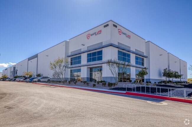
Property Record
1387 Raiders Way, Henderson, NV 89052


NEARBY LISTINGS FOR SALE OR LEASE
Property Detail
1387 Raiders Way
Las Vegas
Matter Park At West Henderson Phase Ii
Las Vegas-Henderson-Paradise, NV
MATTER PARK AT WEST HENDERSON PHASE II PLAT BOOK 164 PAGE 31 PT LOT 1
191-03-216-001
Clark
Foodprocessing
Nevada
2025
1
2025
6.80 AC
005720
SE LV/Henderson
133,576 SF
DEMOGRAPHICS near 1387 Raiders Way
1 Mile
3 Mile
5 Mile
2024 Total Population
8,674
119,470
259,726
2029 Population
9,618
129,782
281,708
Pop Growth 2024-2029
+ 10.88%
+ 8.63%
+ 8.46%
Average Age
36
40
42
2024 Total Households
2,958
46,091
103,361
HH Growth 2024-2029
+ 11.02%
+ 8.50%
+ 8.32%
Median Household Inc
$93,237
$81,414
$84,894
Avg Household Size
2.90
2.60
2.50
2024 Avg HH Vehicles
2.00
2.00
2.00
Median Home Value
$390,642
$428,564
$432,396
Median Year Built
2010
2005
2003
Nearby Places
Map Layers
Map Styles
 Street
 Aerial
- Restaurants
- Banks
- Shops
- Fitness
- Groceries
PUBLIC TRANSPORTATION
AIRPORT
Harry Reid International
DRIVE
WALK
Distance
Harry Reid International
15 min
9.7 mi
Boulder City Municipal
DRIVE
WALK
Distance
Boulder City Municipal
30 min
21.6 mi
Freight Ports
Port of Long Beach
DRIVE
WALK
Distance
Port of Long Beach
302 min
271.3 mi
SALE & LEASE HISTORY
LISTING DATE
SALE/LEASE

Oct 25, 2018
For Lease
May 06, 2022
For Lease
Jan 08, 2019
For Lease
Nearby Properties
Address
Land Use
TOTAL SIZE
Lot Size
Zoning
Address
Land Use
TOTAL SIZE
Lot Size
Zoning
2,340,130 SF
56.10 AC
H1
Address
Land Use
TOTAL SIZE
Lot Size
Zoning
696,660 SF
72.72 AC
Address
Land Use
TOTAL SIZE
Lot Size
Zoning
9,314 SF
23.10 AC
PS
Address
Land Use
TOTAL SIZE
Lot Size
Zoning
882 SF
39.43 AC
Address
Land Use
TOTAL SIZE
Lot Size
Zoning
14,422 SF
30.79 AC
Address
Land Use
TOTAL SIZE
Lot Size
Zoning
197,134 SF
24.59 AC
Address
Land Use
TOTAL SIZE
Lot Size
Zoning
614,616 SF
55.59 AC
Address
Land Use
TOTAL SIZE
Lot Size
Zoning
1,365 SF
22.68 AC
Address
Land Use
TOTAL SIZE
Lot Size
Zoning
5,227 SF
16.79 AC
Address
Land Use
TOTAL SIZE
Lot Size
Zoning
1,184,001 SF
57.02 AC
IP
Address
Land Use
TOTAL SIZE
Lot Size
Zoning
5,975 SF
18.81 AC
Address
Land Use
TOTAL SIZE
Lot Size
Zoning
4,312 SF
19.42 AC
C:R-4
Address
Land Use
TOTAL SIZE
Lot Size
Zoning
5,271 SF
22.88 AC
Address
Land Use
TOTAL SIZE
Lot Size
Zoning
614,520 SF
28.81 AC
Address
Land Use
TOTAL SIZE
Lot Size
Zoning
438,778 SF
19.30 AC
C:R-4
Address
Land Use
TOTAL SIZE
Lot Size
Zoning
3,528 SF
18.15 AC
RH36
Address
Land Use
TOTAL SIZE
Lot Size
Zoning
325,458 SF
15.23 AC
Address
Land Use
TOTAL SIZE
Lot Size
Zoning
7,370 SF
18.03 AC
Address
Land Use
TOTAL SIZE
Lot Size
Zoning
4,924 SF
16.14 AC
C:R-3
Address
Land Use
TOTAL SIZE
Lot Size
Zoning
6,043 SF
15.86 AC
Address
Land Use
TOTAL SIZE
Lot Size
Zoning
161,090 SF
355.75 AC
Address
Land Use
TOTAL SIZE
Lot Size
Zoning
36.85 AC
PS
Address
Land Use
TOTAL SIZE
Lot Size
Zoning
Address
Land Use
TOTAL SIZE
Lot Size
Zoning
3,990 SF
24.88 AC
RM16
Address
Land Use
TOTAL SIZE
Lot Size
Zoning
Address
Land Use
TOTAL SIZE
Lot Size
Zoning
4,405 SF
19.79 AC
Address
Land Use
TOTAL SIZE
Lot Size
Zoning
4,444 SF
18.11 AC
Address
Land Use
TOTAL SIZE
Lot Size
Zoning
220,694 SF
44.74 AC
The World's #1 Commercial Real Estate Marketplace
Connect with us
© 2025 CoStar Group
The information above has been obtained from sources believed reliable. While we do not doubt its accuracy we have not verified it and make no guarantee, warranty or representation about it. It is your responsibility to independently confirm its accuracy and completeness. Any projections, opinions, assumptions, or estimates used are for example only and do not represent the current or future performance of the property. The value of this transaction to you depends on tax and other factors which should be evaluated by your tax, financial, and legal advisors. You and your advisors should conduct a careful, independent investigation of the property to determine to your satisfaction the suitability of the property for your needs.