Property Record
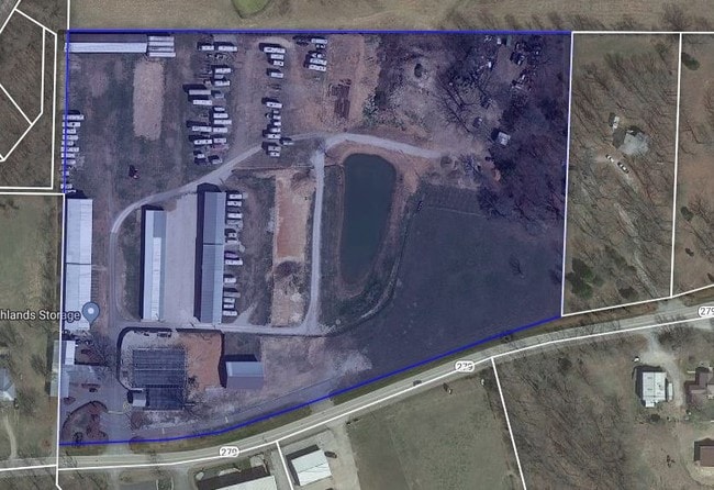
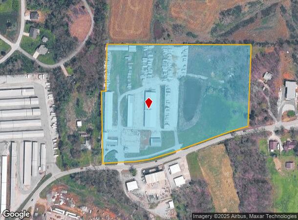
Ar279 Highway 279, Gravette, AR 72736
NEARBY LISTINGS FOR SALE OR LEASE
-
-
View all Gravette listings for sale on LoopNet.com
Property Detail
Ar279 Highway 279
11-00002-180
Gravette
Warehouse
ALL THAT PART OF THE NE/4 OF THE SE/4 LYING NORTH OF STATE HIGHWAY 279 IN SECTION 6, TOWNSHIP 20 NORTH, RANGE 31 WEST, BENTON COUNTY, ARKANSAS. LESS AND EXCEPT: PART OF THE SAID NE/4 OF THE SE/4 DESCRIBED AS BEGINNING AT THE NE CORNER OF THE SAID NE/
X
Benton
29119C0425D
Arkansas
2025
14.19 AC
2025
Outlying Benton County
020905
Fayetteville/Springdale/Rogers
19,976 SF
Fayetteville-Springdale-Rogers, AR-MO
DEMOGRAPHICS near Ar279 Highway 279
1 Mile
3 Mile
5 Mile
2024 Total Population
740
9,902
34,500
2029 Population
875
11,706
40,878
Pop Growth 2024-2029
+ 18.24%
+ 18.22%
+ 18.49%
Average Age
45
48
44
2024 Total Households
295
4,169
13,876
HH Growth 2024-2029
+ 18.31%
+ 18.16%
+ 18.41%
Median Household Inc
$62,547
$78,494
$83,127
Avg Household Size
2.40
2.30
2.50
2024 Avg HH Vehicles
2.00
2.00
2.00
Median Home Value
$222,916
$238,248
$240,426
Median Year Built
2003
2000
1999
Nearby Places
- Restaurants
- Banks
- Shops
- Fitness
- Groceries
PUBLIC TRANSPORTATION
AIRPORT
Northwest Arkansas Ntl
DRIVE
WALK
Distance
Northwest Arkansas Ntl
31 min
14.9 mi
Freight Ports
Tulsa Port of Inola
DRIVE
WALK
Distance
Tulsa Port of Inola
117 min
92.7 mi
Nearby Properties
Address
Land Use
TOTAL SIZE
Lot Size
Zoning
Address
Land Use
TOTAL SIZE
Lot Size
Zoning
79,908 SF
11 AC
Address
Land Use
TOTAL SIZE
Lot Size
Zoning
38,595 SF
6.43 AC
Address
Land Use
TOTAL SIZE
Lot Size
Zoning
29,503 SF
2.59 AC
Address
Land Use
TOTAL SIZE
Lot Size
Zoning
29,560 SF
4.51 AC
Address
Land Use
TOTAL SIZE
Lot Size
Zoning
54,611 SF
4.72 AC
Address
Land Use
TOTAL SIZE
Lot Size
Zoning
11,297 SF
5.96 AC
Address
Land Use
TOTAL SIZE
Lot Size
Zoning
28,000 SF
4.73 AC
Address
Land Use
TOTAL SIZE
Lot Size
Zoning
60,030 SF
5.26 AC
Address
Land Use
TOTAL SIZE
Lot Size
Zoning
40,050 SF
3.23 AC
Address
Land Use
TOTAL SIZE
Lot Size
Zoning
6,768 SF
1.13 AC
Address
Land Use
TOTAL SIZE
Lot Size
Zoning
29,453 SF
6.26 AC
Address
Land Use
TOTAL SIZE
Lot Size
Zoning
32,472 SF
4.40 AC
Address
Land Use
TOTAL SIZE
Lot Size
Zoning
26,792 SF
0.21 AC
Address
Land Use
TOTAL SIZE
Lot Size
Zoning
26,484 SF
0.21 AC
Address
Land Use
TOTAL SIZE
Lot Size
Zoning
26,380 SF
0.21 AC
Address
Land Use
TOTAL SIZE
Lot Size
Zoning
26,227 SF
0.21 AC
Address
Land Use
TOTAL SIZE
Lot Size
Zoning
3,516 SF
1.74 AC
Address
Land Use
TOTAL SIZE
Lot Size
Zoning
57,275 SF
6.76 AC
Address
Land Use
TOTAL SIZE
Lot Size
Zoning
3,873 SF
1.90 AC
Address
Land Use
TOTAL SIZE
Lot Size
Zoning
18,180 SF
2.99 AC
Address
Land Use
TOTAL SIZE
Lot Size
Zoning
10,500 SF
1.30 AC
Address
Land Use
TOTAL SIZE
Lot Size
Zoning
4,590 SF
2 AC
Address
Land Use
TOTAL SIZE
Lot Size
Zoning
29,104 SF
9.78 AC
Address
Land Use
TOTAL SIZE
Lot Size
Zoning
4,949 SF
2.79 AC
Address
Land Use
TOTAL SIZE
Lot Size
Zoning
14,500 SF
2.28 AC
Address
Land Use
TOTAL SIZE
Lot Size
Zoning
3,166 SF
1.50 AC
Address
Land Use
TOTAL SIZE
Lot Size
Zoning
24,587 SF
3.13 AC
Address
Land Use
TOTAL SIZE
Lot Size
Zoning
8,004 SF
1.01 AC
Address
Land Use
TOTAL SIZE
Lot Size
Zoning
7,628 SF
1.38 AC
The World's #1 Commercial Real Estate Marketplace
Connect with us
© 2025 CoStar Group
The information above has been obtained from sources believed reliable. While we do not doubt its accuracy we have not verified it and make no guarantee, warranty or representation about it. It is your responsibility to independently confirm its accuracy and completeness. Any projections, opinions, assumptions, or estimates used are for example only and do not represent the current or future performance of the property. The value of this transaction to you depends on tax and other factors which should be evaluated by your tax, financial, and legal advisors. You and your advisors should conduct a careful, independent investigation of the property to determine to your satisfaction the suitability of the property for your needs.