Property Record
139 32Nd Ave, Fairbanks, AK 99701


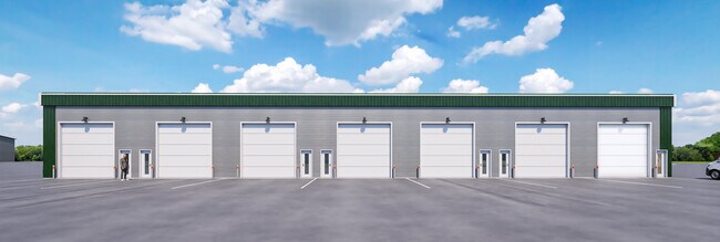
Property Detail
139 32Nd Ave
Fairbanks-College, AK
LOT 14B-1 LEASURE 1ST PREVIOUSLY ASSESSED AS LOTS 1 AND 2 BLOCK 14-A & BLOCK 14-B LEASURE 1ST REPLAT 2021-000170-0 - 1/5/2021
698461
FAIRBANKS NORTH STAR
Commercialnec
Alaska
2025
5.30 AC
2025
Alaska Regional
001000
Other Market Areas
93,583 SF
NEARBY LISTINGS FOR SALE OR LEASE
-
-
View all Fairbanks listings for sale on LoopNet.com
DEMOGRAPHICS near 139 32Nd Ave
1 mile
3 mile
5 mile
2025 Total Population
5,646
30,709
43,457
2030 Population
5,675
30,867
43,548
Pop Growth 2025-2030
+ 0.51%
+ 0.51%
+ 0.21%
Average Age
31
34
35
2025 Total Households
1,896
11,120
16,239
HH Growth 2025-2030
+ 0.32%
+ 0.49%
+ 0.18%
Median Household Inc
$69,874
$72,124
$74,240
Avg Household Size
2.50
2.40
2.40
2025 Avg HH Vehicles
2.00
2.00
2.00
Median Home Value
$140,000
$256,510
$263,992
Median Year Built
1987
1982
1981
Nearby Places
Map Layers
Map Styles
 Street
 Aerial
Layers
 Traffic
 Biking
Places
Listings with unknown addresses are not visible on the map
- Restaurants
- Banks
- Shops
- Fitness
- Groceries
PUBLIC TRANSPORTATION
AIRPORT
Fairbanks International
Drive
Walk
Distance
Fairbanks International
22 min
8.1 mi
Freight Ports
Port of Anchorage
Drive
Walk
Distance
Port of Anchorage
441 min
361.5 mi
SALE & LEASE HISTORY
LISTING DATE
SALE/LEASE

Nov 08, 2024
For Sale
Nearby Properties
Address
Land Use
TOTAL SIZE
Lot Size
Zoning
Address
Land Use
TOTAL SIZE
Lot Size
Zoning
Address
Land Use
TOTAL SIZE
Lot Size
Zoning
Address
Land Use
TOTAL SIZE
Lot Size
Zoning
12,838 SF
Address
Land Use
TOTAL SIZE
Lot Size
Zoning
87.12 AC
Address
Land Use
TOTAL SIZE
Lot Size
Zoning
Address
Land Use
TOTAL SIZE
Lot Size
Zoning
Address
Land Use
TOTAL SIZE
Lot Size
Zoning
65,775.60 AC
Address
Land Use
TOTAL SIZE
Lot Size
Zoning
Address
Land Use
TOTAL SIZE
Lot Size
Zoning
178,992 SF
5.03 AC
Address
Land Use
TOTAL SIZE
Lot Size
Zoning
1,072,047 SF
26.44 AC
Address
Land Use
TOTAL SIZE
Lot Size
Zoning
28,000 SF
5.22 AC
Address
Land Use
TOTAL SIZE
Lot Size
Zoning
479,156 SF
18.38 AC
Address
Land Use
TOTAL SIZE
Lot Size
Zoning
191,644 SF
38.20 AC
Address
Land Use
TOTAL SIZE
Lot Size
Zoning
320,451 SF
27.84 AC
Address
Land Use
TOTAL SIZE
Lot Size
Zoning
254,075 SF
12.42 AC
Address
Land Use
TOTAL SIZE
Lot Size
Zoning
85,213 SF
13.15 AC
Address
Land Use
TOTAL SIZE
Lot Size
Zoning
40,940 SF
41.82 AC
Address
Land Use
TOTAL SIZE
Lot Size
Zoning
59,223 SF
23.57 AC
Address
Land Use
TOTAL SIZE
Lot Size
Zoning
55,734 SF
6 AC
Address
Land Use
TOTAL SIZE
Lot Size
Zoning
64,725 SF
1.72 AC
Address
Land Use
TOTAL SIZE
Lot Size
Zoning
27,007.20 AC
Address
Land Use
TOTAL SIZE
Lot Size
Zoning
49,814 SF
7 AC
Address
Land Use
TOTAL SIZE
Lot Size
Zoning
43,463 SF
76.02 AC
Address
Land Use
TOTAL SIZE
Lot Size
Zoning
43,632 SF
1.27 AC
Address
Land Use
TOTAL SIZE
Lot Size
Zoning
79,445 SF
8.60 AC
Address
Land Use
TOTAL SIZE
Lot Size
Zoning
Address
Land Use
TOTAL SIZE
Lot Size
Zoning
78,313 SF
6.48 AC
Address
Land Use
TOTAL SIZE
Lot Size
Zoning
44,647 SF
2.78 AC
Address
Land Use
TOTAL SIZE
Lot Size
Zoning
21.78 AC
Address
Land Use
TOTAL SIZE
Lot Size
Zoning
The World's #1 Commercial Real Estate Marketplace
Connect with us
© 2026 CoStar Group
The information above has been obtained from sources believed reliable. While we do not doubt its accuracy we have not verified it and make no guarantee, warranty or representation about it. It is your responsibility to independently confirm its accuracy and completeness. Any projections, opinions, assumptions, or estimates used are for example only and do not represent the current or future performance of the property. The value of this transaction to you depends on tax and other factors which should be evaluated by your tax, financial, and legal advisors. You and your advisors should conduct a careful, independent investigation of the property to determine to your satisfaction the suitability of the property for your needs.