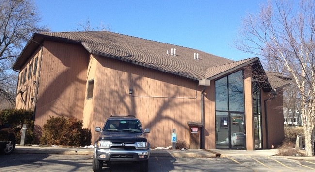
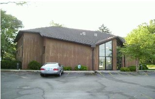
Property Record
139 40Th St Ne, Cedar Rapids, IA 52402

Save to a Folder
{{folder.Name}}
{{folder.ListingIds.length}} Properties
{{folder.ListingIds.length}} Property
Create a New Folder
Property Detail
139 40Th St Ne
Cedar Rapids, IA
A.P. #1 LOT 9 & LOT 10-EX N7 & ALL STR/LB 13
14112-28002-00000
Linn
Officebuilding
Iowa
B and X Area of moderate flood hazard, usually the area between the limits of the 100-year and 500-year floods.
9,10
2024
0.37 AC
2025
Kenwood Park
000700
Other Market Areas
3,465 SF
NEARBY LISTINGS FOR SALE OR LEASE
DEMOGRAPHICS near 139 40Th St Ne
1 mile
3 mile
5 mile
2025 Total Population
7,556
79,573
148,074
2030 Population
7,585
80,281
149,606
Pop Growth 2025-2030
+ 0.38%
+ 0.89%
+ 1.03%
Average Age
41
40
41
2025 Total Households
3,840
34,106
62,307
HH Growth 2025-2030
+ 0.49%
+ 0.94%
+ 1.08%
Median Household Inc
$54,933
$70,412
$71,906
Avg Household Size
1.90
2.20
2.30
2025 Avg HH Vehicles
2.00
2.00
2.00
Median Home Value
$156,722
$196,784
$214,674
Median Year Built
1958
1969
1974
Nearby Places
Map Layers
Map Styles
 Street
 Aerial
Layers
 Traffic
 Biking
Places
Listings with unknown addresses are not visible on the map
- Restaurants
- Banks
- Shops
- Fitness
- Groceries
PUBLIC TRANSPORTATION
AIRPORT
The Eastern Iowa
Drive
Walk
Distance
The Eastern Iowa
23 min
14.2 mi
Freight Ports
Port Milwaukee
Drive
Walk
Distance
Port Milwaukee
288 min
242.5 mi
Nearby Properties
Address
Land Use
TOTAL SIZE
Lot Size
Zoning
Address
Land Use
TOTAL SIZE
Lot Size
Zoning
355,567 SF
14.60 AC
Address
Land Use
TOTAL SIZE
Lot Size
Zoning
264,086 SF
21.44 AC
Address
Land Use
TOTAL SIZE
Lot Size
Zoning
218,747 SF
9.45 AC
Address
Land Use
TOTAL SIZE
Lot Size
Zoning
530,727 SF
28.94 AC
Address
Land Use
TOTAL SIZE
Lot Size
Zoning
73,012 SF
2.60 AC
Address
Land Use
TOTAL SIZE
Lot Size
Zoning
276,234 SF
44.53 AC
Address
Land Use
TOTAL SIZE
Lot Size
Zoning
70,022 SF
8.27 AC
Address
Land Use
TOTAL SIZE
Lot Size
Zoning
60,910 SF
2.48 AC
Address
Land Use
TOTAL SIZE
Lot Size
Zoning
180,790 SF
24.39 AC
Address
Land Use
TOTAL SIZE
Lot Size
Zoning
140,672 SF
15.99 AC
Address
Land Use
TOTAL SIZE
Lot Size
Zoning
1,156,491 SF
137 AC
Address
Land Use
TOTAL SIZE
Lot Size
Zoning
74,015 SF
6.59 AC
Address
Land Use
TOTAL SIZE
Lot Size
Zoning
22,809 SF
21.48 AC
Address
Land Use
TOTAL SIZE
Lot Size
Zoning
203,166 SF
14.16 AC
Address
Land Use
TOTAL SIZE
Lot Size
Zoning
393,375 SF
100.66 AC
Address
Land Use
TOTAL SIZE
Lot Size
Zoning
406,933 SF
61.58 AC
Address
Land Use
TOTAL SIZE
Lot Size
Zoning
34,710 SF
3.30 AC
Address
Land Use
TOTAL SIZE
Lot Size
Zoning
32,855 SF
1.37 AC
Address
Land Use
TOTAL SIZE
Lot Size
Zoning
61,291 SF
35.88 AC
Address
Land Use
TOTAL SIZE
Lot Size
Zoning
155,200 SF
32.40 AC
Address
Land Use
TOTAL SIZE
Lot Size
Zoning
45,012 SF
0.85 AC
Address
Land Use
TOTAL SIZE
Lot Size
Zoning
44,972 SF
7.03 AC
Address
Land Use
TOTAL SIZE
Lot Size
Zoning
50,344 SF
2.92 AC
Address
Land Use
TOTAL SIZE
Lot Size
Zoning
72,227 SF
18.86 AC
Address
Land Use
TOTAL SIZE
Lot Size
Zoning
45,098 SF
3.02 AC
Address
Land Use
TOTAL SIZE
Lot Size
Zoning
90,345 SF
40 AC
Address
Land Use
TOTAL SIZE
Lot Size
Zoning
28,506 SF
5.30 AC
Address
Land Use
TOTAL SIZE
Lot Size
Zoning
1,472,473 SF
395.89 AC
Address
Land Use
TOTAL SIZE
Lot Size
Zoning
70,158 SF
3.76 AC
Address
Land Use
TOTAL SIZE
Lot Size
Zoning
173,941 SF
15.45 AC
The World's #1 Commercial Real Estate Marketplace
Connect with us
© 2026 CoStar Group
The information above has been obtained from sources believed reliable. While we do not doubt its accuracy we have not verified it and make no guarantee, warranty or representation about it. It is your responsibility to independently confirm its accuracy and completeness. Any projections, opinions, assumptions, or estimates used are for example only and do not represent the current or future performance of the property. The value of this transaction to you depends on tax and other factors which should be evaluated by your tax, financial, and legal advisors. You and your advisors should conduct a careful, independent investigation of the property to determine to your satisfaction the suitability of the property for your needs.