Property Record
139 Acres, Oroville, CA 95966
Property Detail
139 Acres
079-260-001-000
LOWER WYANDOTTE RD
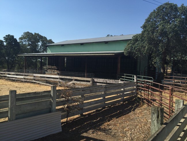
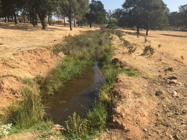
Pasture
BUTTE
AR
California
B and X Area of moderate flood hazard, usually the area between the limits of the 100-year and 500-year floods.
139.07 AC
2024
California North Rural Area
2025
Other Market Areas
003100
Chico, CA
NEARBY LISTINGS FOR SALE OR LEASE
-
-
View all Oroville listings for sale on LoopNet.com
DEMOGRAPHICS near 139 Acres
1 mile
3 mile
5 mile
2025 Total Population
491
11,013
31,585
2030 Population
493
10,916
31,457
Pop Growth 2025-2030
+ 0.41%
(0.88%)
(0.41%)
Average Age
42
41
40
2025 Total Households
170
3,943
11,771
HH Growth 2025-2030
+ 0.59%
(1.04%)
(0.52%)
Median Household Inc
$62,000
$64,539
$57,984
Avg Household Size
2.80
2.60
2.60
2025 Avg HH Vehicles
3.00
2.00
2.00
Median Home Value
$419,166
$328,664
$331,386
Median Year Built
1984
1976
1972
Nearby Places
Map Layers
Map Styles
 Street
 Aerial
Layers
 Traffic
 Biking
Places
Listings with unknown addresses are not visible on the map
- Restaurants
- Banks
- Shops
- Fitness
- Groceries
SALE & LEASE HISTORY
LISTING DATE
SALE/LEASE

Apr 12, 2017
For Sale
Nearby Properties
Address
Land Use
TOTAL SIZE
Lot Size
Zoning
Address
Land Use
TOTAL SIZE
Lot Size
Zoning
36.95 AC
MU-1
Address
Land Use
TOTAL SIZE
Lot Size
Zoning
70,737 SF
12.21 AC
RP
Address
Land Use
TOTAL SIZE
Lot Size
Zoning
67,703 SF
7.82 AC
GI
Address
Land Use
TOTAL SIZE
Lot Size
Zoning
29,326 SF
14.45 AC
HDR
Address
Land Use
TOTAL SIZE
Lot Size
Zoning
14.75 AC
M1
Address
Land Use
TOTAL SIZE
Lot Size
Zoning
62,526 SF
5.01 AC
C2
Address
Land Use
TOTAL SIZE
Lot Size
Zoning
78,190 SF
12.80 AC
M1
Address
Land Use
TOTAL SIZE
Lot Size
Zoning
45,771 SF
4.31 AC
GI
Address
Land Use
TOTAL SIZE
Lot Size
Zoning
8,232 SF
4.58 AC
C2
Address
Land Use
TOTAL SIZE
Lot Size
Zoning
9,100 SF
1.07 AC
Address
Land Use
TOTAL SIZE
Lot Size
Zoning
17,755 SF
2.93 AC
R1
Address
Land Use
TOTAL SIZE
Lot Size
Zoning
13 AC
MU-1
Address
Land Use
TOTAL SIZE
Lot Size
Zoning
4,553 SF
14.82 AC
AR
Address
Land Use
TOTAL SIZE
Lot Size
Zoning
27,954 SF
2.81 AC
RP
Address
Land Use
TOTAL SIZE
Lot Size
Zoning
23,903 SF
3.03 AC
PQ
Address
Land Use
TOTAL SIZE
Lot Size
Zoning
5.45 AC
Address
Land Use
TOTAL SIZE
Lot Size
Zoning
12,652 SF
6.74 AC
Address
Land Use
TOTAL SIZE
Lot Size
Zoning
19,745 SF
2.11 AC
C2
Address
Land Use
TOTAL SIZE
Lot Size
Zoning
12,094 SF
4.94 AC
AR
Address
Land Use
TOTAL SIZE
Lot Size
Zoning
3,391 SF
5.85 AC
AR
Address
Land Use
TOTAL SIZE
Lot Size
Zoning
3,464 SF
82.56 AC
RR-5
Address
Land Use
TOTAL SIZE
Lot Size
Zoning
3,257 SF
11.28 AC
ARMH5
Address
Land Use
TOTAL SIZE
Lot Size
Zoning
1,432 SF
4.52 AC
M1
Address
Land Use
TOTAL SIZE
Lot Size
Zoning
3,643 SF
26.93 AC
RR-5
Address
Land Use
TOTAL SIZE
Lot Size
Zoning
13,500 SF
4.89 AC
M1
Address
Land Use
TOTAL SIZE
Lot Size
Zoning
3,929 SF
10.32 AC
A5
Address
Land Use
TOTAL SIZE
Lot Size
Zoning
6,264 SF
0.42 AC
R1
Address
Land Use
TOTAL SIZE
Lot Size
Zoning
3,169 SF
4.57 AC
Address
Land Use
TOTAL SIZE
Lot Size
Zoning
2,749 SF
5.10 AC
AR
Address
Land Use
TOTAL SIZE
Lot Size
Zoning
1,286 SF
14.69 AC
A5
The World's #1 Commercial Real Estate Marketplace
Connect with us
© 2026 CoStar Group
The information above has been obtained from sources believed reliable. While we do not doubt its accuracy we have not verified it and make no guarantee, warranty or representation about it. It is your responsibility to independently confirm its accuracy and completeness. Any projections, opinions, assumptions, or estimates used are for example only and do not represent the current or future performance of the property. The value of this transaction to you depends on tax and other factors which should be evaluated by your tax, financial, and legal advisors. You and your advisors should conduct a careful, independent investigation of the property to determine to your satisfaction the suitability of the property for your needs.