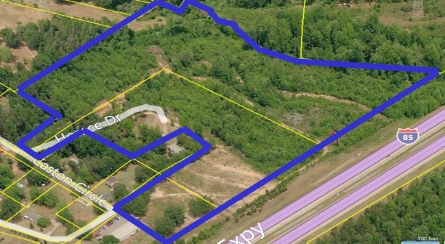
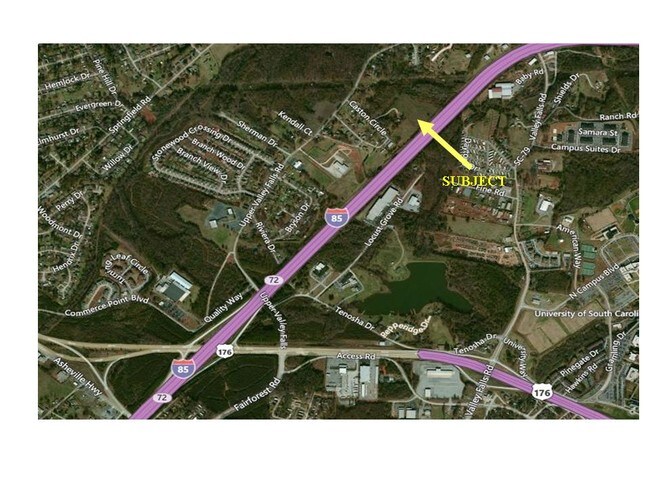
Property Record
139 Caston Cir, Boiling Springs, SC 29316
NEARBY LISTINGS FOR SALE OR LEASE
Property Detail
139 Caston Cir
Spartanburg, SC
Florence A Wilson Estate
2-51-00-019.10
N SIDE CASTON CIR & W OF I-85 PB 146-687 PB 179-483
Residentialacreage
Spartanburg
X
South Carolina
45083C0163D
8.64 AC
2024
North Side/Rt 9 Corridor
2025
Greenville/Spartanburg
021803
DEMOGRAPHICS near 139 Caston Cir
1 Mile
3 Mile
5 Mile
2024 Total Population
5,828
38,255
84,653
2029 Population
6,577
43,162
95,998
Pop Growth 2024-2029
+ 12.85%
+ 12.83%
+ 13.40%
Average Age
34
36
37
2024 Total Households
2,259
13,996
31,415
HH Growth 2024-2029
+ 13.72%
+ 13.22%
+ 13.94%
Median Household Inc
$44,426
$55,740
$52,029
Avg Household Size
2.20
2.50
2.50
2024 Avg HH Vehicles
2.00
2.00
2.00
Median Home Value
$173,097
$174,240
$169,451
Median Year Built
2002
1996
1989
Nearby Places
Map Layers
Map Styles
 Street
 Aerial
- Restaurants
- Banks
- Shops
- Fitness
- Groceries
PUBLIC TRANSPORTATION
COMMUTER RAIL
Spartanburg Amtrak Station (Crescent - Amtrak)
DRIVE
WALK
Distance
Spartanburg Amtrak Station (Crescent - Amtrak)
12 min
6.0 mi
AIRPORT
Greenville Spartanburg International
DRIVE
WALK
Distance
Greenville Spartanburg International
27 min
18.4 mi
Freight Ports
North Charleston Terminal
DRIVE
WALK
Distance
North Charleston Terminal
224 min
199.0 mi
SALE & LEASE HISTORY
LISTING DATE
SALE/LEASE

Sep 24, 2016
For Sale
Nearby Properties
Address
Land Use
TOTAL SIZE
Lot Size
Zoning
Address
Land Use
TOTAL SIZE
Lot Size
Zoning
4,172 SF
15.98 AC
Address
Land Use
TOTAL SIZE
Lot Size
Zoning
27,491 SF
2.95 AC
Address
Land Use
TOTAL SIZE
Lot Size
Zoning
5,547 SF
6.58 AC
Address
Land Use
TOTAL SIZE
Lot Size
Zoning
22,955 SF
5.05 AC
Address
Land Use
TOTAL SIZE
Lot Size
Zoning
19,876 SF
0.03 AC
Address
Land Use
TOTAL SIZE
Lot Size
Zoning
13,160 SF
1.62 AC
Address
Land Use
TOTAL SIZE
Lot Size
Zoning
12,069 SF
0.03 AC
Address
Land Use
TOTAL SIZE
Lot Size
Zoning
Address
Land Use
TOTAL SIZE
Lot Size
Zoning
3,412 SF
21.60 AC
Address
Land Use
TOTAL SIZE
Lot Size
Zoning
122,626 SF
7.70 AC
Address
Land Use
TOTAL SIZE
Lot Size
Zoning
8,872 SF
0.03 AC
Address
Land Use
TOTAL SIZE
Lot Size
Zoning
5,034 SF
17.60 AC
Address
Land Use
TOTAL SIZE
Lot Size
Zoning
83,698 SF
18.14 AC
Address
Land Use
TOTAL SIZE
Lot Size
Zoning
81,040 SF
15.39 AC
Address
Land Use
TOTAL SIZE
Lot Size
Zoning
89,435 SF
5.33 AC
Address
Land Use
TOTAL SIZE
Lot Size
Zoning
101,622 SF
19.63 AC
Address
Land Use
TOTAL SIZE
Lot Size
Zoning
20,976 SF
23.72 AC
Address
Land Use
TOTAL SIZE
Lot Size
Zoning
41,694 SF
4.01 AC
Address
Land Use
TOTAL SIZE
Lot Size
Zoning
2,328 SF
16.99 AC
Address
Land Use
TOTAL SIZE
Lot Size
Zoning
3,112 SF
20.17 AC
Address
Land Use
TOTAL SIZE
Lot Size
Zoning
8,911 SF
23.64 AC
Address
Land Use
TOTAL SIZE
Lot Size
Zoning
6,816 SF
14.16 AC
Address
Land Use
TOTAL SIZE
Lot Size
Zoning
9,649 SF
9.67 AC
Address
Land Use
TOTAL SIZE
Lot Size
Zoning
5,693 SF
0.03 AC
Address
Land Use
TOTAL SIZE
Lot Size
Zoning
7,000 SF
3 AC
Address
Land Use
TOTAL SIZE
Lot Size
Zoning
184,015 SF
19.23 AC
Address
Land Use
TOTAL SIZE
Lot Size
Zoning
64,471 SF
18.66 AC
Address
Land Use
TOTAL SIZE
Lot Size
Zoning
641,891 SF
16.26 AC
Address
Land Use
TOTAL SIZE
Lot Size
Zoning
2,220 SF
14.09 AC
Address
Land Use
TOTAL SIZE
Lot Size
Zoning
76,325 SF
17.28 AC
The World's #1 Commercial Real Estate Marketplace
Connect with us
© 2025 CoStar Group
The information above has been obtained from sources believed reliable. While we do not doubt its accuracy we have not verified it and make no guarantee, warranty or representation about it. It is your responsibility to independently confirm its accuracy and completeness. Any projections, opinions, assumptions, or estimates used are for example only and do not represent the current or future performance of the property. The value of this transaction to you depends on tax and other factors which should be evaluated by your tax, financial, and legal advisors. You and your advisors should conduct a careful, independent investigation of the property to determine to your satisfaction the suitability of the property for your needs.