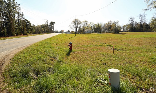
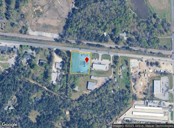
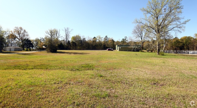
Property Record
139 Chapin Rd, Chapin, SC 29036
NEARBY LISTINGS FOR SALE OR LEASE
Property Detail
139 Chapin Rd
001200-01-003
Prepared For Russell W Dealney & Cynthia
Storebuilding
PARCEL A
X
Lexington
45063C0050J
South Carolina
2025
1.22 AC
2024
Dutch Fork/Irmo
021204
Columbia
844 SF
Columbia, SC
DEMOGRAPHICS near 139 Chapin Rd
1 Mile
3 Mile
5 Mile
2024 Total Population
1,307
16,775
34,298
2029 Population
1,378
17,949
36,291
Pop Growth 2024-2029
+ 5.43%
+ 7.00%
+ 5.81%
Average Age
40
41
41
2024 Total Households
475
6,192
12,784
HH Growth 2024-2029
+ 5.26%
+ 7.11%
+ 6.00%
Median Household Inc
$87,742
$101,790
$105,875
Avg Household Size
2.60
2.70
2.60
2024 Avg HH Vehicles
2.00
2.00
2.00
Median Home Value
$284,648
$339,401
$328,189
Median Year Built
2003
2002
2003
Nearby Places
Map Layers
Map Styles
 Street
 Aerial
- Restaurants
- Banks
- Shops
- Fitness
- Groceries
PUBLIC TRANSPORTATION
AIRPORT
Columbia Metro
DRIVE
WALK
Distance
Columbia Metro
42 min
24.9 mi
Freight Ports
North Charleston Terminal
DRIVE
WALK
Distance
North Charleston Terminal
141 min
121.2 mi
Nearby Properties
Address
Land Use
TOTAL SIZE
Lot Size
Zoning
Address
Land Use
TOTAL SIZE
Lot Size
Zoning
31,005 SF
55.97 AC
PDD
Address
Land Use
TOTAL SIZE
Lot Size
Zoning
1,958 SF
145.19 AC
PDD
Address
Land Use
TOTAL SIZE
Lot Size
Zoning
1,728 SF
5.24 AC
GC
Address
Land Use
TOTAL SIZE
Lot Size
Zoning
57,020 SF
11.80 AC
PDD
Address
Land Use
TOTAL SIZE
Lot Size
Zoning
20,344 SF
13.21 AC
RU
Address
Land Use
TOTAL SIZE
Lot Size
Zoning
19,142 SF
15.08 AC
PDD
Address
Land Use
TOTAL SIZE
Lot Size
Zoning
5,050 SF
4.68 AC
RU
Address
Land Use
TOTAL SIZE
Lot Size
Zoning
4.20 AC
RU
Address
Land Use
TOTAL SIZE
Lot Size
Zoning
15,184 SF
3.17 AC
GC
Address
Land Use
TOTAL SIZE
Lot Size
Zoning
16,034 SF
4.74 AC
RU
Address
Land Use
TOTAL SIZE
Lot Size
Zoning
10,764 SF
1.84 AC
GC
Address
Land Use
TOTAL SIZE
Lot Size
Zoning
15,086 SF
4.85 AC
RU
Address
Land Use
TOTAL SIZE
Lot Size
Zoning
9,124 SF
4.11 AC
RU
Address
Land Use
TOTAL SIZE
Lot Size
Zoning
5,771 SF
7.05 AC
RU
Address
Land Use
TOTAL SIZE
Lot Size
Zoning
60.57 AC
RU
Address
Land Use
TOTAL SIZE
Lot Size
Zoning
6,231 SF
1.83 AC
RU
Address
Land Use
TOTAL SIZE
Lot Size
Zoning
1,343 SF
3.86 AC
NC
Address
Land Use
TOTAL SIZE
Lot Size
Zoning
960 SF
45 AC
RU
Address
Land Use
TOTAL SIZE
Lot Size
Zoning
3,848 SF
1.13 AC
RU
Address
Land Use
TOTAL SIZE
Lot Size
Zoning
22.33 AC
RU
Address
Land Use
TOTAL SIZE
Lot Size
Zoning
3,500 SF
1.90 AC
RU
Address
Land Use
TOTAL SIZE
Lot Size
Zoning
4,956 SF
1.28 AC
PDD
Address
Land Use
TOTAL SIZE
Lot Size
Zoning
36 AC
RU
Address
Land Use
TOTAL SIZE
Lot Size
Zoning
4,800 SF
1.16 AC
RU
Address
Land Use
TOTAL SIZE
Lot Size
Zoning
4,000 SF
1.08 AC
RU
Address
Land Use
TOTAL SIZE
Lot Size
Zoning
8,960 SF
0.75 AC
GC
Address
Land Use
TOTAL SIZE
Lot Size
Zoning
3.47 AC
GC
Address
Land Use
TOTAL SIZE
Lot Size
Zoning
3,000 SF
6.86 AC
RU
Address
Land Use
TOTAL SIZE
Lot Size
Zoning
2,121 SF
1.89 AC
RU
Address
Land Use
TOTAL SIZE
Lot Size
Zoning
66,432 SF
2.89 AC
GC
The World's #1 Commercial Real Estate Marketplace
Connect with us
© 2026 CoStar Group
The information above has been obtained from sources believed reliable. While we do not doubt its accuracy we have not verified it and make no guarantee, warranty or representation about it. It is your responsibility to independently confirm its accuracy and completeness. Any projections, opinions, assumptions, or estimates used are for example only and do not represent the current or future performance of the property. The value of this transaction to you depends on tax and other factors which should be evaluated by your tax, financial, and legal advisors. You and your advisors should conduct a careful, independent investigation of the property to determine to your satisfaction the suitability of the property for your needs.