Property Record
139 Klenc Rd, Springdale, AR 72762


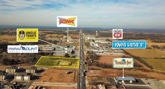
Property Detail
139 Klenc Rd
Fayetteville-Springdale-Rogers, AR
PT NE SE 2.45 AC
830-37708-000
WASHINGTON
Commercialnec
Arkansas
AE The base floodplain where base flood elevations are provided. AE Zones are now used on new format FIRMs instead of A1-A30 Zones.
2.45 AC
2025
Outlying Washington Cnty
2025
Fayetteville/Springdale/Rogers
010518
NEARBY LISTINGS FOR SALE OR LEASE
DEMOGRAPHICS near 139 Klenc Rd
1 mile
3 mile
5 mile
2025 Total Population
2,650
13,581
38,011
2030 Population
2,922
14,794
40,966
Pop Growth 2025-2030
+ 10.26%
+ 8.93%
+ 7.77%
Average Age
41
39
38
2025 Total Households
936
5,018
13,729
HH Growth 2025-2030
+ 10.47%
+ 9.17%
+ 8.00%
Median Household Inc
$100,795
$96,155
$86,961
Avg Household Size
2.80
2.70
2.70
2025 Avg HH Vehicles
2.00
2.00
2.00
Median Home Value
$521,858
$442,491
$373,137
Median Year Built
2003
2006
2001
Nearby Places
Map Layers
Map Styles
 Street
 Aerial
Layers
 Traffic
 Biking
Places
Listings with unknown addresses are not visible on the map
- Restaurants
- Banks
- Shops
- Fitness
- Groceries
PUBLIC TRANSPORTATION
AIRPORT
Northwest Arkansas Ntl
Drive
Walk
Distance
Northwest Arkansas Ntl
26 min
11.0 mi
SALE & LEASE HISTORY
LISTING DATE
SALE/LEASE

Apr 19, 2018
For Sale
Nearby Properties
Address
Land Use
TOTAL SIZE
Lot Size
Zoning
Address
Land Use
TOTAL SIZE
Lot Size
Zoning
54,448 SF
19.43 AC
Address
Land Use
TOTAL SIZE
Lot Size
Zoning
75,774 SF
16.49 AC
Address
Land Use
TOTAL SIZE
Lot Size
Zoning
181,734 SF
21.02 AC
Address
Land Use
TOTAL SIZE
Lot Size
Zoning
112,817 SF
9.57 AC
Address
Land Use
TOTAL SIZE
Lot Size
Zoning
89,280 SF
12.22 AC
Address
Land Use
TOTAL SIZE
Lot Size
Zoning
32,124 SF
6.58 AC
Address
Land Use
TOTAL SIZE
Lot Size
Zoning
72,866 SF
7.14 AC
Address
Land Use
TOTAL SIZE
Lot Size
Zoning
Address
Land Use
TOTAL SIZE
Lot Size
Zoning
39,336 SF
5.03 AC
Address
Land Use
TOTAL SIZE
Lot Size
Zoning
47,780 SF
5.15 AC
PUD
Address
Land Use
TOTAL SIZE
Lot Size
Zoning
165,271 SF
9.94 AC
Address
Land Use
TOTAL SIZE
Lot Size
Zoning
53,921 SF
2.35 AC
Address
Land Use
TOTAL SIZE
Lot Size
Zoning
52,220 SF
4.53 AC
Address
Land Use
TOTAL SIZE
Lot Size
Zoning
116,940 SF
6.44 AC
Address
Land Use
TOTAL SIZE
Lot Size
Zoning
15,698 SF
4.73 AC
Address
Land Use
TOTAL SIZE
Lot Size
Zoning
42,713 SF
13.10 AC
Address
Land Use
TOTAL SIZE
Lot Size
Zoning
31,766 SF
9.36 AC
Address
Land Use
TOTAL SIZE
Lot Size
Zoning
85,000 SF
8.54 AC
Address
Land Use
TOTAL SIZE
Lot Size
Zoning
35,230 SF
7.10 AC
Address
Land Use
TOTAL SIZE
Lot Size
Zoning
88,200 SF
1.46 AC
Address
Land Use
TOTAL SIZE
Lot Size
Zoning
52,972 SF
5.26 AC
Address
Land Use
TOTAL SIZE
Lot Size
Zoning
17,200 SF
4.80 AC
Address
Land Use
TOTAL SIZE
Lot Size
Zoning
26,240 SF
3.06 AC
Address
Land Use
TOTAL SIZE
Lot Size
Zoning
23,520 SF
5.76 AC
Address
Land Use
TOTAL SIZE
Lot Size
Zoning
31,506 SF
4.56 AC
Address
Land Use
TOTAL SIZE
Lot Size
Zoning
32,280 SF
4.88 AC
Address
Land Use
TOTAL SIZE
Lot Size
Zoning
21,068 SF
3.22 AC
Address
Land Use
TOTAL SIZE
Lot Size
Zoning
45,960 SF
4.73 AC
Address
Land Use
TOTAL SIZE
Lot Size
Zoning
46,525 SF
4.85 AC
Address
Land Use
TOTAL SIZE
Lot Size
Zoning
33,122 SF
4.52 AC
The World's #1 Commercial Real Estate Marketplace
Connect with us
© 2026 CoStar Group
The information above has been obtained from sources believed reliable. While we do not doubt its accuracy we have not verified it and make no guarantee, warranty or representation about it. It is your responsibility to independently confirm its accuracy and completeness. Any projections, opinions, assumptions, or estimates used are for example only and do not represent the current or future performance of the property. The value of this transaction to you depends on tax and other factors which should be evaluated by your tax, financial, and legal advisors. You and your advisors should conduct a careful, independent investigation of the property to determine to your satisfaction the suitability of the property for your needs.