Property Record
139 Maher Rd, Royal Oaks, CA 95076

Property Detail
139 Maher Rd
Salinas, CA
ASSRS SUB OF L 3 MP 2 LOS CARNEROS RO POR OF SUB 3 OF LOT C DESC AS PAR B IN PARCEL MP 2 PG 75 60.01 AC APRX
181-161-005-000
MONTEREY
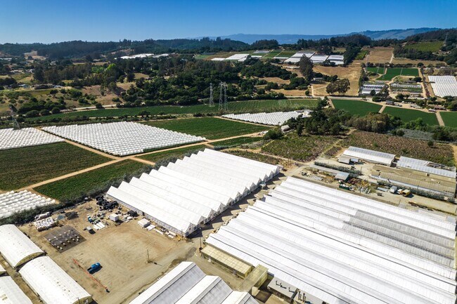
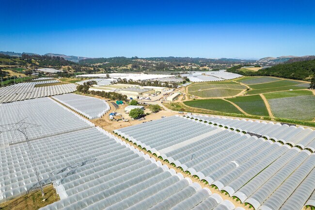
Horticulturegrowinghousesagricultural
California
B and X Area of moderate flood hazard, usually the area between the limits of the 100-year and 500-year floods.
3,c
2024
60 AC
2025
North Monterey County
010202
Salinas
NEARBY LISTINGS FOR SALE OR LEASE
-
-
View all Royal Oaks listings for sale on LoopNet.com
DEMOGRAPHICS near 139 Maher Rd
1 mile
3 mile
5 mile
2025 Total Population
549
7,320
21,176
2030 Population
510
6,843
19,850
Pop Growth 2025-2030
(7.10%)
(6.52%)
(6.26%)
Average Age
42
42
40
2025 Total Households
163
2,207
6,094
HH Growth 2025-2030
(7.36%)
(6.98%)
(6.89%)
Median Household Inc
$103,289
$110,705
$99,261
Avg Household Size
3.10
3.10
3.20
2025 Avg HH Vehicles
3.00
3.00
3.00
Median Home Value
$901,408
$873,944
$806,554
Median Year Built
1980
1980
1977
Nearby Places
Map Layers
Map Styles
 Street
 Aerial
Layers
 Traffic
 Biking
Places
Listings with unknown addresses are not visible on the map
- Restaurants
- Banks
- Shops
- Fitness
- Groceries
PUBLIC TRANSPORTATION
AIRPORT
Monterey Regional
Drive
Walk
Distance
Monterey Regional
40 min
27.0 mi
Freight Ports
Port of Redwood City
Drive
Walk
Distance
Port of Redwood City
92 min
72.1 mi
SALE & LEASE HISTORY
LISTING DATE
SALE/LEASE

Jun 04, 2021
For Sale
Nearby Properties
Address
Land Use
TOTAL SIZE
Lot Size
Zoning
Address
Land Use
TOTAL SIZE
Lot Size
Zoning
31.05 AC
Address
Land Use
TOTAL SIZE
Lot Size
Zoning
171.64 AC
Address
Land Use
TOTAL SIZE
Lot Size
Zoning
43.39 AC
Address
Land Use
TOTAL SIZE
Lot Size
Zoning
112.40 AC
Address
Land Use
TOTAL SIZE
Lot Size
Zoning
10.56 AC
Address
Land Use
TOTAL SIZE
Lot Size
Zoning
27.12 AC
Address
Land Use
TOTAL SIZE
Lot Size
Zoning
17.50 AC
Address
Land Use
TOTAL SIZE
Lot Size
Zoning
96.89 AC
Address
Land Use
TOTAL SIZE
Lot Size
Zoning
103.94 AC
Address
Land Use
TOTAL SIZE
Lot Size
Zoning
32,975 SF
44.13 AC
Address
Land Use
TOTAL SIZE
Lot Size
Zoning
6,503 SF
80.93 AC
Address
Land Use
TOTAL SIZE
Lot Size
Zoning
7,212 SF
0.69 AC
Address
Land Use
TOTAL SIZE
Lot Size
Zoning
1,296 SF
0.90 AC
Address
Land Use
TOTAL SIZE
Lot Size
Zoning
125.40 AC
Address
Land Use
TOTAL SIZE
Lot Size
Zoning
13.15 AC
Address
Land Use
TOTAL SIZE
Lot Size
Zoning
48.53 AC
Address
Land Use
TOTAL SIZE
Lot Size
Zoning
3,830 SF
50 AC
Address
Land Use
TOTAL SIZE
Lot Size
Zoning
1,330 SF
108.50 AC
Address
Land Use
TOTAL SIZE
Lot Size
Zoning
8.95 AC
R
Address
Land Use
TOTAL SIZE
Lot Size
Zoning
11,200 SF
20 AC
Address
Land Use
TOTAL SIZE
Lot Size
Zoning
52.22 AC
Address
Land Use
TOTAL SIZE
Lot Size
Zoning
4,582 SF
56.23 AC
Address
Land Use
TOTAL SIZE
Lot Size
Zoning
2,018 SF
154.92 AC
Address
Land Use
TOTAL SIZE
Lot Size
Zoning
5,073 SF
25.01 AC
Address
Land Use
TOTAL SIZE
Lot Size
Zoning
2,159 SF
1.13 AC
Address
Land Use
TOTAL SIZE
Lot Size
Zoning
36.64 AC
Address
Land Use
TOTAL SIZE
Lot Size
Zoning
4,797 SF
9.86 AC
The World's #1 Commercial Real Estate Marketplace
Connect with us
© 2026 CoStar Group
The information above has been obtained from sources believed reliable. While we do not doubt its accuracy we have not verified it and make no guarantee, warranty or representation about it. It is your responsibility to independently confirm its accuracy and completeness. Any projections, opinions, assumptions, or estimates used are for example only and do not represent the current or future performance of the property. The value of this transaction to you depends on tax and other factors which should be evaluated by your tax, financial, and legal advisors. You and your advisors should conduct a careful, independent investigation of the property to determine to your satisfaction the suitability of the property for your needs.