Property Record
139 Manchester St, Glen Rock, PA 17327


NEARBY LISTINGS FOR SALE OR LEASE
-
-
View all Glen Rock listings for sale on LoopNet.com
Property Detail
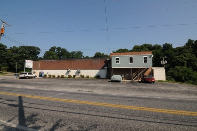
139 Manchester St
Supermarket
York
X
Pennsylvania
42133C0461F
3.27 AC
2025
Outer Hanover/South York County
2025
Philadelphia
023810
York-Hanover, PA
38,200 SF
64-000-01-0036.B0-00000
DEMOGRAPHICS near 139 Manchester St
1 Mile
3 Mile
5 Mile
2024 Total Population
2,932
6,655
23,301
2029 Population
2,999
6,783
23,783
Pop Growth 2024-2029
+ 2.29%
+ 1.92%
+ 2.07%
Average Age
40
42
43
2024 Total Households
1,146
2,595
9,055
HH Growth 2024-2029
+ 2.27%
+ 1.97%
+ 2.15%
Median Household Inc
$83,139
$86,888
$92,010
Avg Household Size
2.60
2.50
2.50
2024 Avg HH Vehicles
2.00
2.00
2.00
Median Home Value
$265,355
$285,670
$286,889
Median Year Built
1970
1974
1980
Nearby Places
Map Layers
Map Styles
 Street
 Aerial
- Restaurants
- Banks
- Shops
- Fitness
- Groceries
PUBLIC TRANSPORTATION
AIRPORT
Harrisburg International
DRIVE
WALK
Distance
Harrisburg International
65 min
45.7 mi
Freight Ports
Port of Baltimore
DRIVE
WALK
Distance
Port of Baltimore
69 min
46.4 mi
SALE & LEASE HISTORY
LISTING DATE
SALE/LEASE

Sep 18, 2018
For Sale
Nov 20, 2019
For Sale
Nearby Properties
Address
Land Use
TOTAL SIZE
Lot Size
Zoning
Address
Land Use
TOTAL SIZE
Lot Size
Zoning
0.45 AC
AG
Address
Land Use
TOTAL SIZE
Lot Size
Zoning
84,460 SF
10.04 AC
RS
Address
Land Use
TOTAL SIZE
Lot Size
Zoning
2,820 SF
4.54 AC
CN
Address
Land Use
TOTAL SIZE
Lot Size
Zoning
8,720 SF
127.58 AC
AG
Address
Land Use
TOTAL SIZE
Lot Size
Zoning
5,906 SF
191.11 AC
AG
Address
Land Use
TOTAL SIZE
Lot Size
Zoning
12,544 SF
3.35 AC
R1
Address
Land Use
TOTAL SIZE
Lot Size
Zoning
47,787 SF
0.83 AC
RS
Address
Land Use
TOTAL SIZE
Lot Size
Zoning
1,446 SF
4.79 AC
CM
Address
Land Use
TOTAL SIZE
Lot Size
Zoning
3,180 SF
73.62 AC
Address
Land Use
TOTAL SIZE
Lot Size
Zoning
24,716 SF
1.35 AC
RS
Address
Land Use
TOTAL SIZE
Lot Size
Zoning
10,400 SF
1.21 AC
CM
Address
Land Use
TOTAL SIZE
Lot Size
Zoning
5,330 SF
84.06 AC
AG
Address
Land Use
TOTAL SIZE
Lot Size
Zoning
8,624 SF
0.23 AC
RS
Address
Land Use
TOTAL SIZE
Lot Size
Zoning
4,627 SF
49.52 AC
AG
Address
Land Use
TOTAL SIZE
Lot Size
Zoning
5,504 SF
50.60 AC
AG
Address
Land Use
TOTAL SIZE
Lot Size
Zoning
9,360 SF
6.52 AC
C
Address
Land Use
TOTAL SIZE
Lot Size
Zoning
4,698 SF
10.34 AC
RA
Address
Land Use
TOTAL SIZE
Lot Size
Zoning
3,435 SF
105.92 AC
AG
Address
Land Use
TOTAL SIZE
Lot Size
Zoning
4,276 SF
48.91 AC
AG
Address
Land Use
TOTAL SIZE
Lot Size
Zoning
4,325 SF
54.20 AC
AG
Address
Land Use
TOTAL SIZE
Lot Size
Zoning
3,868 SF
49 AC
AG
Address
Land Use
TOTAL SIZE
Lot Size
Zoning
3,500 SF
4.15 AC
CM
Address
Land Use
TOTAL SIZE
Lot Size
Zoning
3,592 SF
17 AC
AG
Address
Land Use
TOTAL SIZE
Lot Size
Zoning
33,280 SF
0.57 AC
RS
Address
Land Use
TOTAL SIZE
Lot Size
Zoning
4,527 SF
51.69 AC
AG
Address
Land Use
TOTAL SIZE
Lot Size
Zoning
4,342 SF
119.03 AC
AG
Address
Land Use
TOTAL SIZE
Lot Size
Zoning
10,500 SF
1.26 AC
RS
Address
Land Use
TOTAL SIZE
Lot Size
Zoning
3,491 SF
32.35 AC
AG
Address
Land Use
TOTAL SIZE
Lot Size
Zoning
5,806 SF
9.56 AC
AG
The World's #1 Commercial Real Estate Marketplace
Connect with us
© 2026 CoStar Group
The information above has been obtained from sources believed reliable. While we do not doubt its accuracy we have not verified it and make no guarantee, warranty or representation about it. It is your responsibility to independently confirm its accuracy and completeness. Any projections, opinions, assumptions, or estimates used are for example only and do not represent the current or future performance of the property. The value of this transaction to you depends on tax and other factors which should be evaluated by your tax, financial, and legal advisors. You and your advisors should conduct a careful, independent investigation of the property to determine to your satisfaction the suitability of the property for your needs.