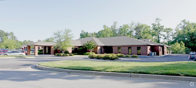
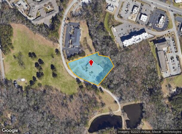
Property Record
139 Summerplace Dr, West Columbia, SC 29169

NEARBY LISTINGS FOR SALE OR LEASE
Property Detail
139 Summerplace Dr
Columbia, SC
Summerplace Medical Park
004597-10-080
SUMMERPLACE MEDICAL PARK PH I LOT 2 & 3
Medicalclinic
Lexington
AE
South Carolina
45063C0163J
2
0
2.53 AC
2024
Cayce/West Columbia
020506
Columbia
14,154 SF
DEMOGRAPHICS near 139 Summerplace Dr
1 Mile
3 Mile
5 Mile
2024 Total Population
5,938
44,002
133,217
2029 Population
6,501
47,506
141,630
Pop Growth 2024-2029
+ 9.48%
+ 7.96%
+ 6.32%
Average Age
42
40
38
2024 Total Households
2,790
19,614
56,795
HH Growth 2024-2029
+ 9.71%
+ 8.00%
+ 6.55%
Median Household Inc
$59,863
$55,520
$54,535
Avg Household Size
2.00
2.20
2.20
2024 Avg HH Vehicles
1.00
2.00
2.00
Median Home Value
$165,741
$162,463
$164,587
Median Year Built
1995
1977
1978
Nearby Places
Map Layers
Map Styles
 Street
 Aerial
- Restaurants
- Banks
- Shops
- Fitness
- Groceries
PUBLIC TRANSPORTATION
COMMUTER RAIL
Columbia Amtrak Station (Silver Star - Amtrak)
DRIVE
WALK
Distance
Columbia Amtrak Station (Silver Star - Amtrak)
10 min
5.2 mi
AIRPORT
Columbia Metro
DRIVE
WALK
Distance
Columbia Metro
19 min
8.5 mi
Freight Ports
North Charleston Terminal
DRIVE
WALK
Distance
North Charleston Terminal
119 min
104.8 mi
Nearby Properties
Address
Land Use
TOTAL SIZE
Lot Size
Zoning
Address
Land Use
TOTAL SIZE
Lot Size
Zoning
119,738 SF
10.30 AC
EC
Address
Land Use
TOTAL SIZE
Lot Size
Zoning
128,160 SF
9.31 AC
RM-HD
Address
Land Use
TOTAL SIZE
Lot Size
Zoning
358,561 SF
42.10 AC
EC
Address
Land Use
TOTAL SIZE
Lot Size
Zoning
9,620 SF
18.91 AC
GC
Address
Land Use
TOTAL SIZE
Lot Size
Zoning
183,392 SF
14.77 AC
RM-HD
Address
Land Use
TOTAL SIZE
Lot Size
Zoning
245,506 SF
14.13 AC
GC
Address
Land Use
TOTAL SIZE
Lot Size
Zoning
220,568 SF
14.53 AC
RM-2
Address
Land Use
TOTAL SIZE
Lot Size
Zoning
231,468 SF
17.41 AC
RM-2
Address
Land Use
TOTAL SIZE
Lot Size
Zoning
247,360 SF
6.61 AC
EC
Address
Land Use
TOTAL SIZE
Lot Size
Zoning
129,108 SF
11.90 AC
RM-HD
Address
Land Use
TOTAL SIZE
Lot Size
Zoning
204,968 SF
17.39 AC
RM-HD
Address
Land Use
TOTAL SIZE
Lot Size
Zoning
125,561 SF
12.10 AC
EC
Address
Land Use
TOTAL SIZE
Lot Size
Zoning
131,628 SF
4.39 AC
GC
Address
Land Use
TOTAL SIZE
Lot Size
Zoning
89,376 SF
6.85 AC
CAC
Address
Land Use
TOTAL SIZE
Lot Size
Zoning
80,000 SF
4.76 AC
EC
Address
Land Use
TOTAL SIZE
Lot Size
Zoning
122,820 SF
10.46 AC
RM-HD
Address
Land Use
TOTAL SIZE
Lot Size
Zoning
44,296 SF
14.01 AC
GC
Address
Land Use
TOTAL SIZE
Lot Size
Zoning
144,351 SF
17.88 AC
RM-2
Address
Land Use
TOTAL SIZE
Lot Size
Zoning
82,874 SF
6.99 AC
GC
Address
Land Use
TOTAL SIZE
Lot Size
Zoning
151,470 SF
8.44 AC
RM-2
Address
Land Use
TOTAL SIZE
Lot Size
Zoning
81,900 SF
4.95 AC
EC
Address
Land Use
TOTAL SIZE
Lot Size
Zoning
78,288 SF
5.14 AC
GC
Address
Land Use
TOTAL SIZE
Lot Size
Zoning
70,843 SF
1.89 AC
GC
Address
Land Use
TOTAL SIZE
Lot Size
Zoning
20,200 SF
13.92 AC
GC
Address
Land Use
TOTAL SIZE
Lot Size
Zoning
208,016 SF
14.28 AC
GC
Address
Land Use
TOTAL SIZE
Lot Size
Zoning
108,246 SF
4.46 AC
GC
Address
Land Use
TOTAL SIZE
Lot Size
Zoning
51,216 SF
2.30 AC
EC
Address
Land Use
TOTAL SIZE
Lot Size
Zoning
282,660 SF
41.39 AC
RAC
Address
Land Use
TOTAL SIZE
Lot Size
Zoning
70,000 SF
11.32 AC
LI
Address
Land Use
TOTAL SIZE
Lot Size
Zoning
42,072 SF
2.01 AC
GC
The World's #1 Commercial Real Estate Marketplace
Connect with us
© 2026 CoStar Group
The information above has been obtained from sources believed reliable. While we do not doubt its accuracy we have not verified it and make no guarantee, warranty or representation about it. It is your responsibility to independently confirm its accuracy and completeness. Any projections, opinions, assumptions, or estimates used are for example only and do not represent the current or future performance of the property. The value of this transaction to you depends on tax and other factors which should be evaluated by your tax, financial, and legal advisors. You and your advisors should conduct a careful, independent investigation of the property to determine to your satisfaction the suitability of the property for your needs.