Property Record
13901 Interstate 35 S, Von Ormy, TX 78073
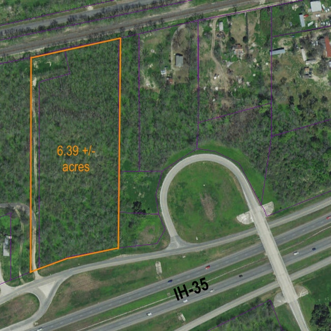

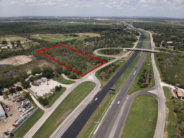
This Property Is For Sale
Property Detail
13901 Interstate 35 S
San Antonio-New Braunfels, TX
CB 4231C BLK LOT 17, 18, 19 & E IRR 30.12 FT OF 16 2016-ADDED LEGAL AGREAGE TO MATCH DEED 17681/2494 EXE 2-4-16 JF/GIS/3-18-16
04231-300-0170
BEXAR
Vacantlandnec
Texas
AE The base floodplain where base flood elevations are provided. AE Zones are now used on new format FIRMs instead of A1-A30 Zones.
17
2024
5.47 AC
2025
South
162001
San Antonio
NEARBY LISTINGS FOR SALE OR LEASE
DEMOGRAPHICS near 13901 Interstate 35 S
1 mile
3 mile
5 mile
2024 Total Population
668
4,080
37,639
2029 Population
691
4,398
39,914
Pop Growth 2024-2029
+ 3.44%
+ 7.79%
+ 6.04%
Average Age
39
38
34
2024 Total Households
219
1,309
10,997
HH Growth 2024-2029
+ 3.65%
+ 8.02%
+ 6.34%
Median Household Inc
$60,409
$68,309
$57,962
Avg Household Size
3.10
3.10
3.40
2024 Avg HH Vehicles
2.00
2.00
2.00
Median Home Value
$226,923
$289,670
$216,864
Median Year Built
1986
1994
1991
Nearby Places
Map Layers
Map Styles
 Street
 Aerial
Transit
 Traffic
 Biking
Places
Listings with unknown addresses are not visible on the map
- Restaurants
- Banks
- Shops
- Fitness
- Groceries
PUBLIC TRANSPORTATION
AIRPORT
San Antonio International
Drive
Walk
Distance
San Antonio International
30 min
22.8 mi
Freight Ports
Port of Corpus Christi
Drive
Walk
Distance
Port of Corpus Christi
155 min
146.3 mi
Nearby Properties
Address
Land Use
TOTAL SIZE
Lot Size
Zoning
Address
Land Use
TOTAL SIZE
Lot Size
Zoning
677,476 SF
52.48 AC
Address
Land Use
TOTAL SIZE
Lot Size
Zoning
283,920 SF
20.13 AC
Address
Land Use
TOTAL SIZE
Lot Size
Zoning
221,256 SF
53.05 AC
Address
Land Use
TOTAL SIZE
Lot Size
Zoning
94,561 SF
34.91 AC
Address
Land Use
TOTAL SIZE
Lot Size
Zoning
198,000 SF
9.93 AC
Address
Land Use
TOTAL SIZE
Lot Size
Zoning
241,162 SF
15.60 AC
Address
Land Use
TOTAL SIZE
Lot Size
Zoning
1,530 SF
418.50 AC
Address
Land Use
TOTAL SIZE
Lot Size
Zoning
396.49 AC
Address
Land Use
TOTAL SIZE
Lot Size
Zoning
1,930,397 SF
16.57 AC
Address
Land Use
TOTAL SIZE
Lot Size
Zoning
342.37 AC
Address
Land Use
TOTAL SIZE
Lot Size
Zoning
3,402,154 SF
153.79 AC
Address
Land Use
TOTAL SIZE
Lot Size
Zoning
532.27 AC
Address
Land Use
TOTAL SIZE
Lot Size
Zoning
56,658 SF
3.68 AC
Address
Land Use
TOTAL SIZE
Lot Size
Zoning
150 SF
27.35 AC
Address
Land Use
TOTAL SIZE
Lot Size
Zoning
80.71 AC
Address
Land Use
TOTAL SIZE
Lot Size
Zoning
3,633 SF
304.96 AC
Address
Land Use
TOTAL SIZE
Lot Size
Zoning
48,846 SF
8.62 AC
Address
Land Use
TOTAL SIZE
Lot Size
Zoning
94,992 SF
8.40 AC
Address
Land Use
TOTAL SIZE
Lot Size
Zoning
88,513 SF
10.10 AC
Address
Land Use
TOTAL SIZE
Lot Size
Zoning
78.80 AC
Address
Land Use
TOTAL SIZE
Lot Size
Zoning
110.78 AC
Address
Land Use
TOTAL SIZE
Lot Size
Zoning
1,596 SF
349.51 AC
Address
Land Use
TOTAL SIZE
Lot Size
Zoning
380.06 AC
Address
Land Use
TOTAL SIZE
Lot Size
Zoning
34,450 SF
10.10 AC
Address
Land Use
TOTAL SIZE
Lot Size
Zoning
26.95 AC
Address
Land Use
TOTAL SIZE
Lot Size
Zoning
11,770 SF
143.84 AC
Address
Land Use
TOTAL SIZE
Lot Size
Zoning
105.75 AC
Address
Land Use
TOTAL SIZE
Lot Size
Zoning
Address
Land Use
TOTAL SIZE
Lot Size
Zoning
15,600 SF
5.19 AC
Address
Land Use
TOTAL SIZE
Lot Size
Zoning
84.38 AC
The World's #1 Commercial Real Estate Marketplace
Connect with us
© 2026 CoStar Group
The information above has been obtained from sources believed reliable. While we do not doubt its accuracy we have not verified it and make no guarantee, warranty or representation about it. It is your responsibility to independently confirm its accuracy and completeness. Any projections, opinions, assumptions, or estimates used are for example only and do not represent the current or future performance of the property. The value of this transaction to you depends on tax and other factors which should be evaluated by your tax, financial, and legal advisors. You and your advisors should conduct a careful, independent investigation of the property to determine to your satisfaction the suitability of the property for your needs.