Property Record
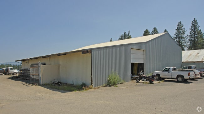
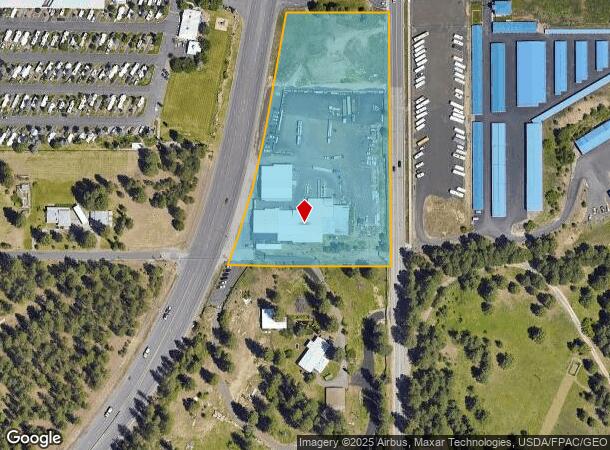
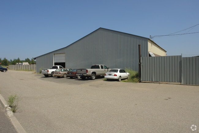
13906 N Newport Hwy, Mead, WA 99021

NEARBY LISTINGS FOR SALE OR LEASE
Property Detail
13906 N Newport Hwy
Spokane-Spokane Valley, WA
City Gardens
36031.0139
CITY GARDENS PTN TRS 7 & 7A LYG ELY OF SR#6, TR 8 EXC SR#6 & EXC E60FT FOR HWY TOGETHER WITH VAC BOSTON RD LYG WITHIN. TOGW N 1/2 VAC DEER RD RES #95-1067 (AFN 6785598) & TOGW S1/2 VAC DEER RD RES #95-1067 (AFN 6805168)
Wholesaleoutletdiscountstore
Spokane
X
Washington
53063C0390D
7,7a
2025
5.18 AC
2025
NE North Metro
011202
Spokane
27,626 SF
DEMOGRAPHICS near 13906 N Newport Hwy
1 Mile
3 Mile
5 Mile
2024 Total Population
3,898
22,603
61,959
2029 Population
4,104
23,905
65,606
Pop Growth 2024-2029
+ 5.28%
+ 5.76%
+ 5.89%
Average Age
42
41
40
2024 Total Households
1,479
8,213
23,581
HH Growth 2024-2029
+ 5.34%
+ 5.92%
+ 6.12%
Median Household Inc
$74,222
$86,962
$72,359
Avg Household Size
2.60
2.70
2.50
2024 Avg HH Vehicles
2.00
2.00
2.00
Median Home Value
$365,423
$410,824
$387,493
Median Year Built
1990
1993
1989
Nearby Places
Map Layers
Map Styles
 Street
 Aerial
- Restaurants
- Banks
- Shops
- Fitness
- Groceries
PUBLIC TRANSPORTATION
AIRPORT
Spokane International
DRIVE
WALK
Distance
Spokane International
32 min
19.0 mi
Nearby Properties
Address
Land Use
TOTAL SIZE
Lot Size
Zoning
Address
Land Use
TOTAL SIZE
Lot Size
Zoning
157,654 SF
77.80 AC
RT
Address
Land Use
TOTAL SIZE
Lot Size
Zoning
78,497 SF
9.19 AC
MU
Address
Land Use
TOTAL SIZE
Lot Size
Zoning
215,573 SF
11.30 AC
HDR
Address
Land Use
TOTAL SIZE
Lot Size
Zoning
172,525 SF
8.18 AC
HDR
Address
Land Use
TOTAL SIZE
Lot Size
Zoning
166,390 SF
19.33 AC
MU
Address
Land Use
TOTAL SIZE
Lot Size
Zoning
142,776 SF
77.39 AC
UR
Address
Land Use
TOTAL SIZE
Lot Size
Zoning
209,047 SF
41.68 AC
HI
Address
Land Use
TOTAL SIZE
Lot Size
Zoning
121,519 SF
6.26 AC
HDR
Address
Land Use
TOTAL SIZE
Lot Size
Zoning
64,558 SF
11.91 AC
LDR
Address
Land Use
TOTAL SIZE
Lot Size
Zoning
317,432 SF
36.25 AC
LDR
Address
Land Use
TOTAL SIZE
Lot Size
Zoning
165,954 SF
15.18 AC
RC
Address
Land Use
TOTAL SIZE
Lot Size
Zoning
105,791 SF
22.82 AC
LDR
Address
Land Use
TOTAL SIZE
Lot Size
Zoning
43,391 SF
16.06 AC
MU
Address
Land Use
TOTAL SIZE
Lot Size
Zoning
75,957 SF
3.19 AC
Address
Land Use
TOTAL SIZE
Lot Size
Zoning
236,659 SF
14.84 AC
MU
Address
Land Use
TOTAL SIZE
Lot Size
Zoning
185,014 SF
314.71 AC
HI
Address
Land Use
TOTAL SIZE
Lot Size
Zoning
67,763 SF
13.12 AC
LDR
Address
Land Use
TOTAL SIZE
Lot Size
Zoning
122,970 SF
6.28 AC
RC
Address
Land Use
TOTAL SIZE
Lot Size
Zoning
47,452 SF
10.33 AC
LDR
Address
Land Use
TOTAL SIZE
Lot Size
Zoning
46,350 SF
38.98 AC
RCV
Address
Land Use
TOTAL SIZE
Lot Size
Zoning
19.30 AC
Address
Land Use
TOTAL SIZE
Lot Size
Zoning
51,613 SF
21.83 AC
RCV
Address
Land Use
TOTAL SIZE
Lot Size
Zoning
47,533 SF
5.85 AC
RC
Address
Land Use
TOTAL SIZE
Lot Size
Zoning
52,908 SF
12.11 AC
LI
Address
Land Use
TOTAL SIZE
Lot Size
Zoning
53,840 SF
8.82 AC
MU
Address
Land Use
TOTAL SIZE
Lot Size
Zoning
32,512 SF
8.55 AC
UR
Address
Land Use
TOTAL SIZE
Lot Size
Zoning
116,369 SF
3.34 AC
HDR
Address
Land Use
TOTAL SIZE
Lot Size
Zoning
46,620 SF
1.82 AC
MU
Address
Land Use
TOTAL SIZE
Lot Size
Zoning
93,150 SF
9.82 AC
LI
Address
Land Use
TOTAL SIZE
Lot Size
Zoning
45,306 SF
2.39 AC
HDR
The World's #1 Commercial Real Estate Marketplace
Connect with us
© 2025 CoStar Group
The information above has been obtained from sources believed reliable. While we do not doubt its accuracy we have not verified it and make no guarantee, warranty or representation about it. It is your responsibility to independently confirm its accuracy and completeness. Any projections, opinions, assumptions, or estimates used are for example only and do not represent the current or future performance of the property. The value of this transaction to you depends on tax and other factors which should be evaluated by your tax, financial, and legal advisors. You and your advisors should conduct a careful, independent investigation of the property to determine to your satisfaction the suitability of the property for your needs.