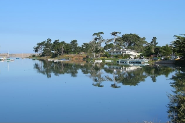
Property Record
1391 2Nd St, Los Osos, CA 93402
Property Detail
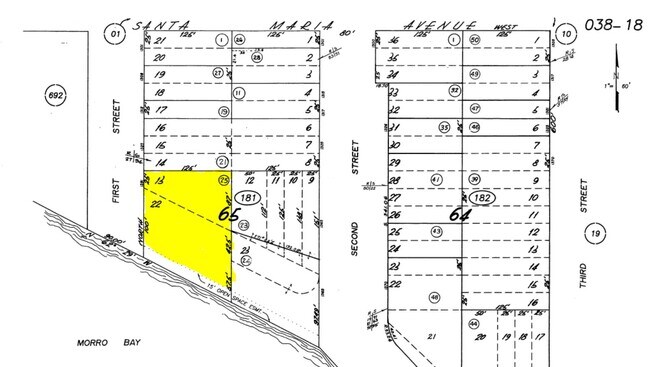
1391 2Nd St
038-181-025
TN EL MORO BL 65 LT 23 & PTN LTS 9 TO 12
Motel
San Luis Obispo
CR
California
AE The base floodplain where base flood elevations are provided. AE Zones are now used on new format FIRMs instead of A1-A30 Zones.
23,9
2024
0.45 AC
2025
San Luis Obispo/Paso Robles
010701
San Luis Obispo/Paso Robles
6,382 SF
San Luis Obispo-Paso Robles, CA
NEARBY LISTINGS FOR SALE OR LEASE
DEMOGRAPHICS near 1391 2Nd St
1 mile
3 mile
5 mile
2025 Total Population
7,311
18,144
23,744
2030 Population
7,166
17,936
23,642
Pop Growth 2025-2030
(1.98%)
(1.15%)
(0.43%)
Average Age
45
48
48
2025 Total Households
2,960
7,867
10,400
HH Growth 2025-2030
(2.33%)
(1.28%)
(0.54%)
Median Household Inc
$97,651
$97,149
$97,835
Avg Household Size
2.40
2.20
2.20
2025 Avg HH Vehicles
2.00
2.00
2.00
Median Home Value
$760,091
$811,226
$819,421
Median Year Built
1975
1974
1974
Nearby Places
Map Layers
Map Styles
 Street
 Aerial
Layers
 Traffic
 Biking
Places
Listings with unknown addresses are not visible on the map
- Restaurants
- Banks
- Shops
- Fitness
- Groceries
PUBLIC TRANSPORTATION
AIRPORT
San Luis County Regional
Drive
Walk
Distance
San Luis County Regional
29 min
14.6 mi
Freight Ports
The Port of Hueneme
Drive
Walk
Distance
The Port of Hueneme
185 min
141.9 mi
Nearby Properties
Address
Land Use
TOTAL SIZE
Lot Size
Zoning
Address
Land Use
TOTAL SIZE
Lot Size
Zoning
92,746 SF
5.27 AC
C2
Address
Land Use
TOTAL SIZE
Lot Size
Zoning
21,263 SF
0.43 AC
PD
Address
Land Use
TOTAL SIZE
Lot Size
Zoning
70,323 SF
5.38 AC
CR
Address
Land Use
TOTAL SIZE
Lot Size
Zoning
42,742 SF
4.47 AC
VSC
Address
Land Use
TOTAL SIZE
Lot Size
Zoning
48.18 AC
PF
Address
Land Use
TOTAL SIZE
Lot Size
Zoning
1.35 AC
CR
Address
Land Use
TOTAL SIZE
Lot Size
Zoning
47,906 SF
4.49 AC
C1
Address
Land Use
TOTAL SIZE
Lot Size
Zoning
19,329 SF
0.40 AC
C1
Address
Land Use
TOTAL SIZE
Lot Size
Zoning
0.40 AC
R4
Address
Land Use
TOTAL SIZE
Lot Size
Zoning
18 AC
REC
Address
Land Use
TOTAL SIZE
Lot Size
Zoning
8,439 SF
0.28 AC
VSC
Address
Land Use
TOTAL SIZE
Lot Size
Zoning
2.99 AC
20
Address
Land Use
TOTAL SIZE
Lot Size
Zoning
26,037 SF
0.50 AC
PD
Address
Land Use
TOTAL SIZE
Lot Size
Zoning
6,588 SF
0.53 AC
60
Address
Land Use
TOTAL SIZE
Lot Size
Zoning
9,418 SF
0.37 AC
CVS
Address
Land Use
TOTAL SIZE
Lot Size
Zoning
11,285 SF
0.40 AC
VSC
Address
Land Use
TOTAL SIZE
Lot Size
Zoning
18,592 SF
2.15 AC
RMF
Address
Land Use
TOTAL SIZE
Lot Size
Zoning
2.06 AC
RMF
Address
Land Use
TOTAL SIZE
Lot Size
Zoning
6,948 SF
0.23 AC
Address
Land Use
TOTAL SIZE
Lot Size
Zoning
15,516 SF
0.80 AC
C1
Address
Land Use
TOTAL SIZE
Lot Size
Zoning
14,220 SF
1.03 AC
C1
Address
Land Use
TOTAL SIZE
Lot Size
Zoning
5,661 SF
0.54 AC
CVS
Address
Land Use
TOTAL SIZE
Lot Size
Zoning
38,728 SF
1.46 AC
60
Address
Land Use
TOTAL SIZE
Lot Size
Zoning
9,160 SF
0.40 AC
CVS
Address
Land Use
TOTAL SIZE
Lot Size
Zoning
23,636 SF
2.57 AC
C1
Address
Land Use
TOTAL SIZE
Lot Size
Zoning
5,564 SF
0.14 AC
C1
Address
Land Use
TOTAL SIZE
Lot Size
Zoning
11,657 SF
0.34 AC
CR
Address
Land Use
TOTAL SIZE
Lot Size
Zoning
17,200 SF
0.40 AC
R2PD
Address
Land Use
TOTAL SIZE
Lot Size
Zoning
13,224 SF
0.19 AC
Address
Land Use
TOTAL SIZE
Lot Size
Zoning
4,974 SF
0.34 AC
CVS
The World's #1 Commercial Real Estate Marketplace
Connect with us
© 2026 CoStar Group
The information above has been obtained from sources believed reliable. While we do not doubt its accuracy we have not verified it and make no guarantee, warranty or representation about it. It is your responsibility to independently confirm its accuracy and completeness. Any projections, opinions, assumptions, or estimates used are for example only and do not represent the current or future performance of the property. The value of this transaction to you depends on tax and other factors which should be evaluated by your tax, financial, and legal advisors. You and your advisors should conduct a careful, independent investigation of the property to determine to your satisfaction the suitability of the property for your needs.