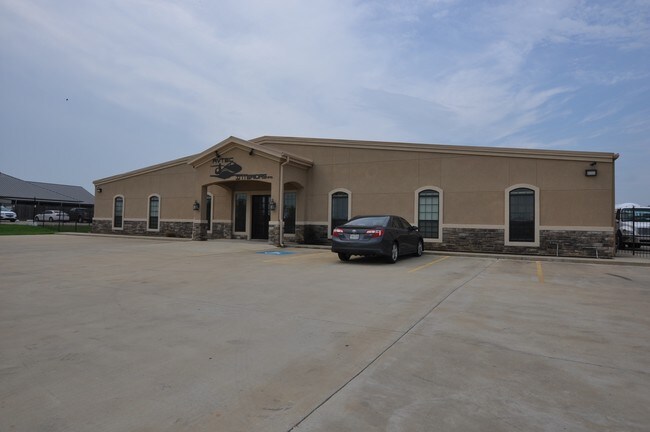
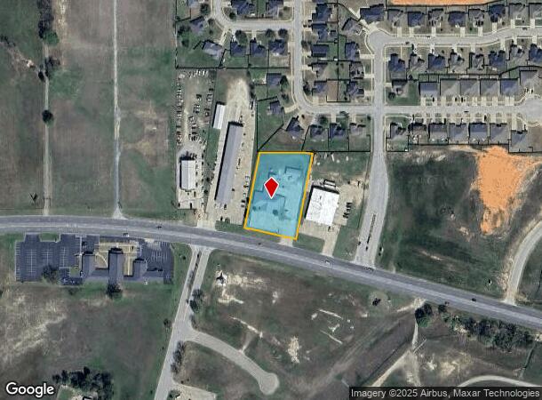
Property Record
13910 State Highway 64 W, Tyler, TX 75704

NEARBY LISTINGS FOR SALE OR LEASE
Property Detail
13910 State Highway 64 W
Tyler, TX
Wellington Place
1-85705-0000-01-042010
WELLINGTON PLACELOT 42A
Officebuilding
Smith
X
Texas
48423C0350D
42a
2024
1.36 AC
2025
Tyler & Longview
001606
Other Market Areas
6,849 SF
DEMOGRAPHICS near 13910 State Highway 64 W
1 Mile
3 Mile
5 Mile
2024 Total Population
626
9,326
30,638
2029 Population
683
10,172
33,343
Pop Growth 2024-2029
+ 9.11%
+ 9.07%
+ 8.83%
Average Age
36
38
37
2024 Total Households
219
3,338
11,042
HH Growth 2024-2029
+ 8.68%
+ 8.45%
+ 8.25%
Median Household Inc
$39,062
$58,813
$52,028
Avg Household Size
2.70
2.70
2.70
2024 Avg HH Vehicles
2.00
2.00
2.00
Median Home Value
$175,757
$141,531
$121,145
Median Year Built
1977
1975
1973
Nearby Places
Map Layers
Map Styles
 Street
 Aerial
- Restaurants
- Banks
- Shops
- Fitness
- Groceries
PUBLIC TRANSPORTATION
AIRPORT
Tyler Pounds Regional
DRIVE
WALK
Distance
Tyler Pounds Regional
6 min
2.0 mi
Freight Ports
Port of Shreveport
DRIVE
WALK
Distance
Port of Shreveport
129 min
112.2 mi
SALE & LEASE HISTORY
LISTING DATE
SALE/LEASE

Sep 24, 2016
For Sale
Nearby Properties
Address
Land Use
TOTAL SIZE
Lot Size
Zoning
Address
Land Use
TOTAL SIZE
Lot Size
Zoning
187.64 AC
R1A
Address
Land Use
TOTAL SIZE
Lot Size
Zoning
311.96 AC
Address
Land Use
TOTAL SIZE
Lot Size
Zoning
22.85 AC
Address
Land Use
TOTAL SIZE
Lot Size
Zoning
Address
Land Use
TOTAL SIZE
Lot Size
Zoning
25.57 AC
Address
Land Use
TOTAL SIZE
Lot Size
Zoning
54.04 AC
Address
Land Use
TOTAL SIZE
Lot Size
Zoning
239,900 SF
52.09 AC
Address
Land Use
TOTAL SIZE
Lot Size
Zoning
1,868 SF
2.24 AC
Address
Land Use
TOTAL SIZE
Lot Size
Zoning
4,747 SF
42.83 AC
Address
Land Use
TOTAL SIZE
Lot Size
Zoning
8,195 SF
3.13 AC
Address
Land Use
TOTAL SIZE
Lot Size
Zoning
16,353 SF
7.80 AC
Address
Land Use
TOTAL SIZE
Lot Size
Zoning
17,000 SF
89.17 AC
Address
Land Use
TOTAL SIZE
Lot Size
Zoning
6,038 SF
1.38 AC
Address
Land Use
TOTAL SIZE
Lot Size
Zoning
20.10 AC
R1A
Address
Land Use
TOTAL SIZE
Lot Size
Zoning
25,000 SF
12.09 AC
Address
Land Use
TOTAL SIZE
Lot Size
Zoning
60,000 SF
10.72 AC
M1
Address
Land Use
TOTAL SIZE
Lot Size
Zoning
6,289 SF
12.66 AC
Address
Land Use
TOTAL SIZE
Lot Size
Zoning
43,637 SF
3 AC
Address
Land Use
TOTAL SIZE
Lot Size
Zoning
69,000 SF
6 AC
Address
Land Use
TOTAL SIZE
Lot Size
Zoning
24,271 SF
8.37 AC
C2
Address
Land Use
TOTAL SIZE
Lot Size
Zoning
5,000 SF
2.93 AC
Address
Land Use
TOTAL SIZE
Lot Size
Zoning
8,400 SF
5.51 AC
R1A
Address
Land Use
TOTAL SIZE
Lot Size
Zoning
12,719 SF
1.22 AC
Address
Land Use
TOTAL SIZE
Lot Size
Zoning
11,325 SF
2 AC
Address
Land Use
TOTAL SIZE
Lot Size
Zoning
49,400 SF
4.83 AC
Address
Land Use
TOTAL SIZE
Lot Size
Zoning
300 SF
9.64 AC
Address
Land Use
TOTAL SIZE
Lot Size
Zoning
19,520 SF
3.51 AC
C2
Address
Land Use
TOTAL SIZE
Lot Size
Zoning
19,520 SF
3.28 AC
C2
Address
Land Use
TOTAL SIZE
Lot Size
Zoning
6,700 SF
1.63 AC
Address
Land Use
TOTAL SIZE
Lot Size
Zoning
19,600 SF
2.28 AC
C2
The World's #1 Commercial Real Estate Marketplace
Connect with us
© 2026 CoStar Group
The information above has been obtained from sources believed reliable. While we do not doubt its accuracy we have not verified it and make no guarantee, warranty or representation about it. It is your responsibility to independently confirm its accuracy and completeness. Any projections, opinions, assumptions, or estimates used are for example only and do not represent the current or future performance of the property. The value of this transaction to you depends on tax and other factors which should be evaluated by your tax, financial, and legal advisors. You and your advisors should conduct a careful, independent investigation of the property to determine to your satisfaction the suitability of the property for your needs.