Property Record
13910 State Highway 138, Hesperia, CA 92345
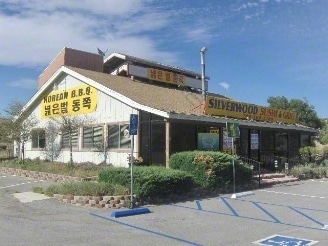
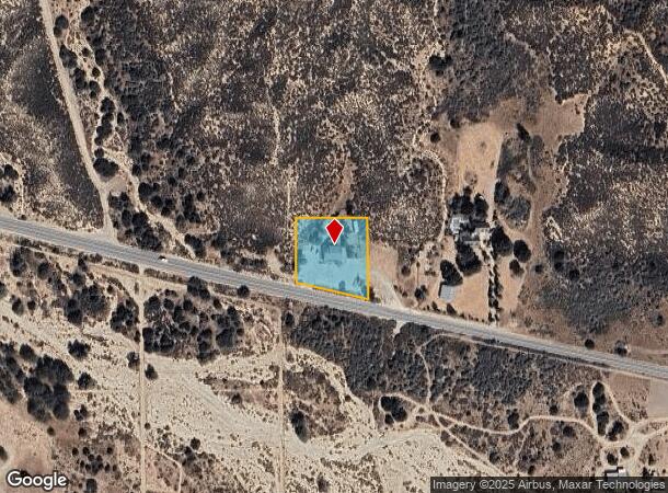
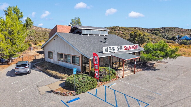

This Property Is For Sale
NEARBY LISTINGS FOR SALE OR LEASE
-
-
View all Hesperia listings for sale on LoopNet.com
Property Detail
13910 State Highway 138
0357-132-05
PTN S 1/2 NE 1/4 SW 1/4 SEC 25 TP 3N R 5W DESC AS COM NW COR SD S 1/2 TH S ALG W LI NE 1/4 SW 1/4 242.22 FT TO C/L STATE HGWY 59 TH SELY ALG SD C/L 322.5 FT TH N AND PARALLEL WITH W LI NE 1/4 SW 1/4 310.16 FT TO N LI SD S 1/2 TH W ALG SD N LI 315.17
Restaurantbuilding
San Bernardino
X
California
06071C7225H
1.06 AC
2024
Mojave River Valley
2025
Inland Empire (California)
010024
Riverside-San Bernardino-Ontario, CA
3,524 SF
DEMOGRAPHICS near 13910 State Highway 138
1 Mile
3 Mile
5 Mile
2024 Total Population
31
253
7,910
2029 Population
31
258
8,009
Pop Growth 2024-2029
0.00%
+ 1.98%
+ 1.25%
Average Age
41
41
39
2024 Total Households
10
86
2,443
HH Growth 2024-2029
+ 10.00%
+ 1.16%
+ 1.02%
Median Household Inc
$124,999
$92,045
$79,041
Avg Household Size
3.00
2.90
3.20
2024 Avg HH Vehicles
3.00
3.00
3.00
Median Home Value
$474,999
$499,999
$412,864
Median Year Built
1989
1987
1993
Nearby Places
- Restaurants
- Banks
- Shops
- Fitness
- Groceries
PUBLIC TRANSPORTATION
AIRPORT
Ontario International
DRIVE
WALK
Distance
Ontario International
41 min
33.1 mi
Freight Ports
Port of Long Beach
DRIVE
WALK
Distance
Port of Long Beach
103 min
85.2 mi
Nearby Properties
Address
Land Use
TOTAL SIZE
Lot Size
Zoning
Address
Land Use
TOTAL SIZE
Lot Size
Zoning
320 AC
RL10AP
Address
Land Use
TOTAL SIZE
Lot Size
Zoning
3,479 SF
3.58 AC
CG
Address
Land Use
TOTAL SIZE
Lot Size
Zoning
1,225 SF
80 AC
RS1
Address
Land Use
TOTAL SIZE
Lot Size
Zoning
28.68 AC
RS
Address
Land Use
TOTAL SIZE
Lot Size
Zoning
35 AC
RS1
Address
Land Use
TOTAL SIZE
Lot Size
Zoning
10 AC
RS14M
Address
Land Use
TOTAL SIZE
Lot Size
Zoning
79.45 AC
RC
Address
Land Use
TOTAL SIZE
Lot Size
Zoning
2,000 SF
0.47 AC
Address
Land Use
TOTAL SIZE
Lot Size
Zoning
62.69 AC
RS1
Address
Land Use
TOTAL SIZE
Lot Size
Zoning
400 SF
5.01 AC
Address
Land Use
TOTAL SIZE
Lot Size
Zoning
16 AC
RS
Address
Land Use
TOTAL SIZE
Lot Size
Zoning
35 AC
IC
Address
Land Use
TOTAL SIZE
Lot Size
Zoning
4.12 AC
RM
Address
Land Use
TOTAL SIZE
Lot Size
Zoning
5 AC
RS1
Address
Land Use
TOTAL SIZE
Lot Size
Zoning
10 AC
RS1
Address
Land Use
TOTAL SIZE
Lot Size
Zoning
9.58 AC
RM
Address
Land Use
TOTAL SIZE
Lot Size
Zoning
Address
Land Use
TOTAL SIZE
Lot Size
Zoning
Address
Land Use
TOTAL SIZE
Lot Size
Zoning
10 AC
RS1
Address
Land Use
TOTAL SIZE
Lot Size
Zoning
2.07 AC
RS1
Address
Land Use
TOTAL SIZE
Lot Size
Zoning
5 AC
RM
Address
Land Use
TOTAL SIZE
Lot Size
Zoning
39.17 AC
RS
The World's #1 Commercial Real Estate Marketplace
Connect with us
© 2025 CoStar Group
The information above has been obtained from sources believed reliable. While we do not doubt its accuracy we have not verified it and make no guarantee, warranty or representation about it. It is your responsibility to independently confirm its accuracy and completeness. Any projections, opinions, assumptions, or estimates used are for example only and do not represent the current or future performance of the property. The value of this transaction to you depends on tax and other factors which should be evaluated by your tax, financial, and legal advisors. You and your advisors should conduct a careful, independent investigation of the property to determine to your satisfaction the suitability of the property for your needs.