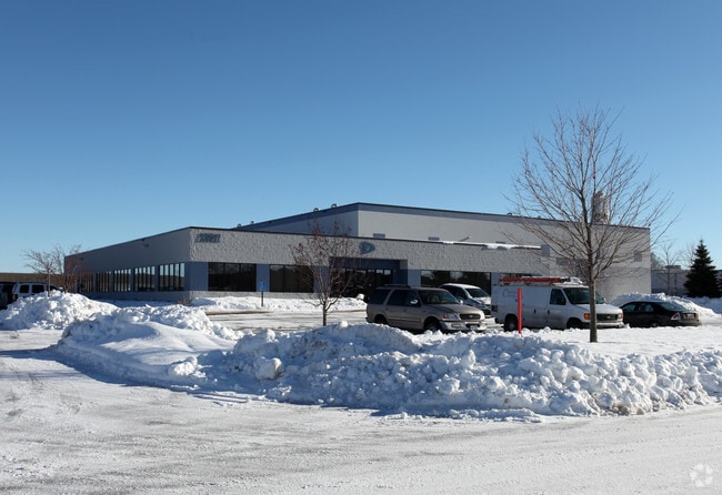
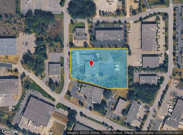
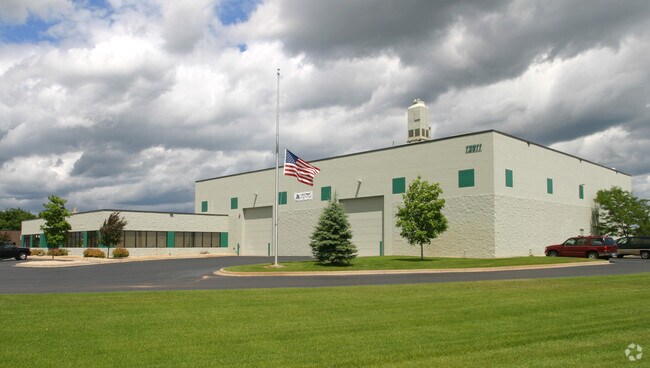
Property Record
13911 Unity St Nw, Anoka, MN 55303

NEARBY LISTINGS FOR SALE OR LEASE
Property Detail
13911 Unity St Nw
Minneapolis-St. Paul-Bloomington, MN-WI
Business Park 95 6Th Add
35-32-25-24-0016
LOT 1 BLOCK 1 BUSINESS PARK 95 6TH ADD
Industrialgeneral
Anoka
X
Minnesota
27053C0060F
1
2024
4.04 AC
2025
North Central
050227
Minneapolis/St Paul
23,268 SF
DEMOGRAPHICS near 13911 Unity St Nw
1 Mile
3 Mile
5 Mile
2024 Total Population
3,427
44,987
92,547
2029 Population
3,542
46,606
95,114
Pop Growth 2024-2029
+ 3.36%
+ 3.60%
+ 2.77%
Average Age
37
39
40
2024 Total Households
1,182
17,042
34,772
HH Growth 2024-2029
+ 3.30%
+ 3.70%
+ 2.82%
Median Household Inc
$93,049
$89,664
$93,344
Avg Household Size
2.80
2.60
2.60
2024 Avg HH Vehicles
2.00
2.00
2.00
Median Home Value
$311,212
$309,082
$311,547
Median Year Built
1994
1990
1987
Nearby Places
Map Layers
Map Styles
 Street
 Aerial
- Restaurants
- Banks
- Shops
- Fitness
- Groceries
PUBLIC TRANSPORTATION
COMMUTER RAIL
DRIVE
WALK
Distance
6 min
2.5 mi
Anoka Station (Northstar Corridor - Northstar Commuter Rail)
DRIVE
WALK
Distance
Anoka Station (Northstar Corridor - Northstar Commuter Rail)
8 min
3.5 mi
AIRPORT
Minneapolis-St Paul International/Wold-Chamberlain
DRIVE
WALK
Distance
Minneapolis-St Paul International/Wold-Chamberlain
50 min
35.5 mi
Nearby Properties
Address
Land Use
TOTAL SIZE
Lot Size
Zoning
Address
Land Use
TOTAL SIZE
Lot Size
Zoning
468,099 SF
5.73 AC
MSMU
Address
Land Use
TOTAL SIZE
Lot Size
Zoning
3.80 AC
Address
Land Use
TOTAL SIZE
Lot Size
Zoning
3,491 SF
3.03 AC
Address
Land Use
TOTAL SIZE
Lot Size
Zoning
2,400 SF
72.45 AC
Address
Land Use
TOTAL SIZE
Lot Size
Zoning
363,449 SF
82.99 AC
R-1
Address
Land Use
TOTAL SIZE
Lot Size
Zoning
68,362 SF
Address
Land Use
TOTAL SIZE
Lot Size
Zoning
225,748 SF
Address
Land Use
TOTAL SIZE
Lot Size
Zoning
382,508 SF
Address
Land Use
TOTAL SIZE
Lot Size
Zoning
343,297 SF
25.42 AC
M-1
Address
Land Use
TOTAL SIZE
Lot Size
Zoning
153,964 SF
3.90 AC
Address
Land Use
TOTAL SIZE
Lot Size
Zoning
140,288 SF
5.12 AC
Address
Land Use
TOTAL SIZE
Lot Size
Zoning
300,547 SF
19.21 AC
Address
Land Use
TOTAL SIZE
Lot Size
Zoning
298,148 SF
17.70 AC
M-1
Address
Land Use
TOTAL SIZE
Lot Size
Zoning
319,019 SF
17.14 AC
Address
Land Use
TOTAL SIZE
Lot Size
Zoning
147,000 SF
Address
Land Use
TOTAL SIZE
Lot Size
Zoning
147,000 SF
Address
Land Use
TOTAL SIZE
Lot Size
Zoning
114,281 SF
3.19 AC
PRD-4
Address
Land Use
TOTAL SIZE
Lot Size
Zoning
319,664 SF
19.62 AC
M-1
Address
Land Use
TOTAL SIZE
Lot Size
Zoning
436,117 SF
17.75 AC
M-1
Address
Land Use
TOTAL SIZE
Lot Size
Zoning
190,285 SF
12.98 AC
Address
Land Use
TOTAL SIZE
Lot Size
Zoning
118,208 SF
Address
Land Use
TOTAL SIZE
Lot Size
Zoning
Address
Land Use
TOTAL SIZE
Lot Size
Zoning
155,849 SF
0.83 AC
Address
Land Use
TOTAL SIZE
Lot Size
Zoning
201,859 SF
9.21 AC
Address
Land Use
TOTAL SIZE
Lot Size
Zoning
811,860 SF
Address
Land Use
TOTAL SIZE
Lot Size
Zoning
100 SF
5.42 AC
R-2
Address
Land Use
TOTAL SIZE
Lot Size
Zoning
60,588 SF
4.56 AC
Address
Land Use
TOTAL SIZE
Lot Size
Zoning
111,300 SF
Address
Land Use
TOTAL SIZE
Lot Size
Zoning
Address
Land Use
TOTAL SIZE
Lot Size
Zoning
83,357 SF
5.35 AC
The World's #1 Commercial Real Estate Marketplace
Connect with us
© 2025 CoStar Group
The information above has been obtained from sources believed reliable. While we do not doubt its accuracy we have not verified it and make no guarantee, warranty or representation about it. It is your responsibility to independently confirm its accuracy and completeness. Any projections, opinions, assumptions, or estimates used are for example only and do not represent the current or future performance of the property. The value of this transaction to you depends on tax and other factors which should be evaluated by your tax, financial, and legal advisors. You and your advisors should conduct a careful, independent investigation of the property to determine to your satisfaction the suitability of the property for your needs.