Property Record
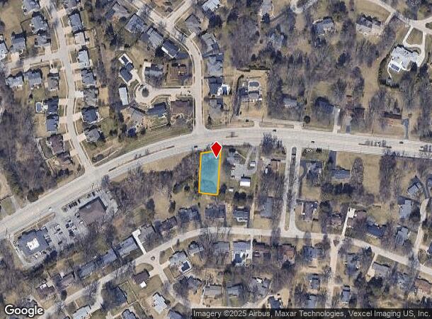
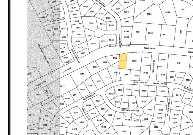
13918 Olive Blvd, Chesterfield, MO 63017

NEARBY LISTINGS FOR SALE OR LEASE
Property Detail
13918 Olive Blvd
St. Louis, MO-IL
Missouri Steven Estate Lot Pt 7 Share 5
16Q-13-0711
MISSOURI STEVEN ESTATE LOT PT 7 SHARE 5 BDY ADJ LOT PT W (EXCESS ACQUISITION)
Vacantlandnec
St. Louis
X
Missouri
29183C0470G
7
2024
0.34 AC
2025
Chesterfield/Hwy-40
215231
St. Louis
DEMOGRAPHICS near 13918 Olive Blvd
1 Mile
3 Mile
5 Mile
2024 Total Population
5,705
35,145
121,450
2029 Population
5,576
34,444
120,351
Pop Growth 2024-2029
(2.26%)
(1.99%)
(0.90%)
Average Age
43
45
43
2024 Total Households
2,323
14,749
49,953
HH Growth 2024-2029
(2.28%)
(2.01%)
(1.00%)
Median Household Inc
$100,598
$105,242
$108,093
Avg Household Size
2.40
2.30
2.30
2024 Avg HH Vehicles
2.00
2.00
2.00
Median Home Value
$371,722
$367,105
$351,959
Median Year Built
1968
1976
1978
Nearby Places
Map Layers
Map Styles
 Street
 Aerial
- Restaurants
- Banks
- Shops
- Fitness
- Groceries
PUBLIC TRANSPORTATION
AIRPORT
St Louis Lambert International
DRIVE
WALK
Distance
St Louis Lambert International
26 min
16.4 mi
Nearby Properties
Address
Land Use
TOTAL SIZE
Lot Size
Zoning
Address
Land Use
TOTAL SIZE
Lot Size
Zoning
200,372 SF
121.45 AC
105FPNU
Address
Land Use
TOTAL SIZE
Lot Size
Zoning
43,574 SF
55.62 AC
NU
Address
Land Use
TOTAL SIZE
Lot Size
Zoning
1,298,224 SF
194.08 AC
C-8
Address
Land Use
TOTAL SIZE
Lot Size
Zoning
3,220 SF
31.26 AC
CB
Address
Land Use
TOTAL SIZE
Lot Size
Zoning
587,809 SF
36.69 AC
105NU
Address
Land Use
TOTAL SIZE
Lot Size
Zoning
28.46 AC
104NU
Address
Land Use
TOTAL SIZE
Lot Size
Zoning
352,152 SF
31.79 AC
105C8
Address
Land Use
TOTAL SIZE
Lot Size
Zoning
12,017 SF
122.40 AC
NU
Address
Land Use
TOTAL SIZE
Lot Size
Zoning
247,860 SF
21.11 AC
105MU
Address
Land Use
TOTAL SIZE
Lot Size
Zoning
272,522 SF
8.70 AC
83POP
Address
Land Use
TOTAL SIZE
Lot Size
Zoning
252,737 SF
24.69 AC
R3
Address
Land Use
TOTAL SIZE
Lot Size
Zoning
68,279 SF
95.59 AC
NU
Address
Land Use
TOTAL SIZE
Lot Size
Zoning
13.45 AC
PD-M
Address
Land Use
TOTAL SIZE
Lot Size
Zoning
340,320 SF
55.62 AC
NU
Address
Land Use
TOTAL SIZE
Lot Size
Zoning
302,420 SF
13.97 AC
NU
Address
Land Use
TOTAL SIZE
Lot Size
Zoning
200,840 SF
12.29 AC
105C8
Address
Land Use
TOTAL SIZE
Lot Size
Zoning
359,937 SF
26.91 AC
R4
Address
Land Use
TOTAL SIZE
Lot Size
Zoning
42,037 SF
193.91 AC
NU
Address
Land Use
TOTAL SIZE
Lot Size
Zoning
36.41 AC
R2
Address
Land Use
TOTAL SIZE
Lot Size
Zoning
389,367 SF
29.15 AC
R6
Address
Land Use
TOTAL SIZE
Lot Size
Zoning
146,175 SF
1.41 AC
83POP
Address
Land Use
TOTAL SIZE
Lot Size
Zoning
212,180 SF
2.03 AC
83POP
Address
Land Use
TOTAL SIZE
Lot Size
Zoning
108,384 SF
6.05 AC
105PC
Address
Land Use
TOTAL SIZE
Lot Size
Zoning
158,326 SF
9.26 AC
83POP
Address
Land Use
TOTAL SIZE
Lot Size
Zoning
153,316 SF
6.44 AC
105PC
Address
Land Use
TOTAL SIZE
Lot Size
Zoning
456,388 SF
13.75 AC
83POP
Address
Land Use
TOTAL SIZE
Lot Size
Zoning
241,519 SF
19.30 AC
R7
Address
Land Use
TOTAL SIZE
Lot Size
Zoning
23.93 AC
82A
Address
Land Use
TOTAL SIZE
Lot Size
Zoning
5,712 SF
9.90 AC
105R3
Address
Land Use
TOTAL SIZE
Lot Size
Zoning
119,860 SF
8.62 AC
NU
The World's #1 Commercial Real Estate Marketplace
Connect with us
© 2025 CoStar Group
The information above has been obtained from sources believed reliable. While we do not doubt its accuracy we have not verified it and make no guarantee, warranty or representation about it. It is your responsibility to independently confirm its accuracy and completeness. Any projections, opinions, assumptions, or estimates used are for example only and do not represent the current or future performance of the property. The value of this transaction to you depends on tax and other factors which should be evaluated by your tax, financial, and legal advisors. You and your advisors should conduct a careful, independent investigation of the property to determine to your satisfaction the suitability of the property for your needs.