Property Record
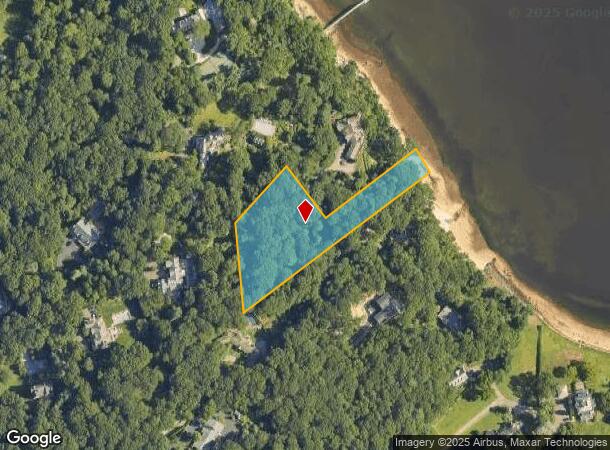
1392 Ridge Rd, Laurel Hollow, NY 11791
NEARBY LISTINGS FOR SALE OR LEASE
-
-
View all Laurel Hollow listings for sale on LoopNet.com
Property Detail
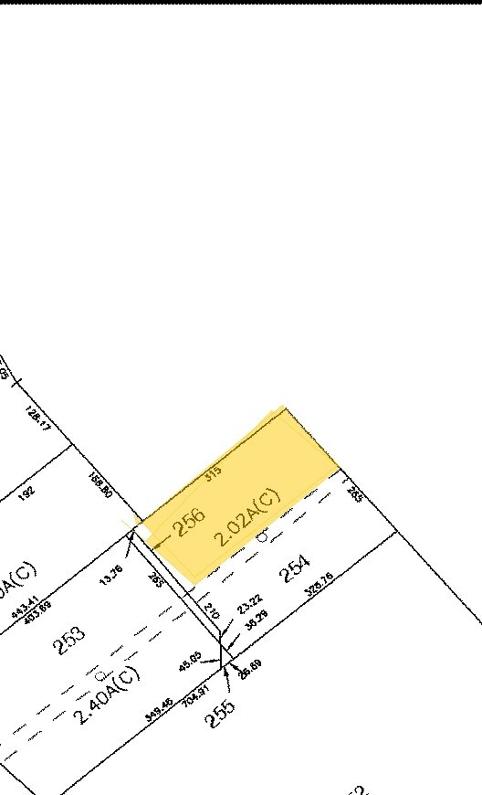
1392 Ridge Rd
2413-26-C-00-2119-0
TOWN #3 SCH DIST 011
Residentialacreage
Nassau
VE
New York
36103C0605H
2119
2025
2.02 AC
2025
Northern Nassau
518201
Long Island (New York)
5,229 SF
Nassau County-Suffolk County, NY
DEMOGRAPHICS near 1392 Ridge Rd
1 Mile
3 Mile
5 Mile
2024 Total Population
1,402
30,015
112,546
2029 Population
1,388
29,563
110,571
Pop Growth 2024-2029
(1.00%)
(1.51%)
(1.75%)
Average Age
42
43
42
2024 Total Households
446
10,700
38,107
HH Growth 2024-2029
(1.35%)
(1.72%)
(1.88%)
Median Household Inc
$238,182
$164,996
$142,492
Avg Household Size
3.10
2.70
2.80
2024 Avg HH Vehicles
3.00
2.00
2.00
Median Home Value
$1,109,000
$884,678
$762,275
Median Year Built
1962
1958
1959
Nearby Places
- Restaurants
- Banks
- Shops
- Fitness
- Groceries
PUBLIC TRANSPORTATION
COMMUTER RAIL
Cold Spring Harbor Station (Port Jefferson Branch - Long Island Rail Road)
DRIVE
WALK
Distance
Cold Spring Harbor Station (Port Jefferson Branch - Long Island Rail Road)
9 min
3.4 mi
Oyster Bay Station (Oyster Bay Branch - Long Island Rail Road)
DRIVE
WALK
Distance
Oyster Bay Station (Oyster Bay Branch - Long Island Rail Road)
11 min
4.0 mi
AIRPORT
Long Island MacArthur
DRIVE
WALK
Distance
Long Island MacArthur
45 min
24.1 mi
LaGuardia
DRIVE
WALK
Distance
LaGuardia
45 min
27.7 mi
Westchester County
DRIVE
WALK
Distance
Westchester County
75 min
46.6 mi
Freight Ports
NY - Red Hook Container Terminal
DRIVE
WALK
Distance
NY - Red Hook Container Terminal
57 min
35.8 mi
Nearby Properties
Address
Land Use
TOTAL SIZE
Lot Size
Zoning
Address
Land Use
TOTAL SIZE
Lot Size
Zoning
42.21 AC
CA
Address
Land Use
TOTAL SIZE
Lot Size
Zoning
441,456 SF
47.92 AC
Address
Land Use
TOTAL SIZE
Lot Size
Zoning
300,526 SF
44.30 AC
Address
Land Use
TOTAL SIZE
Lot Size
Zoning
1.50 AC
R40
Address
Land Use
TOTAL SIZE
Lot Size
Zoning
75,253 SF
44.28 AC
Address
Land Use
TOTAL SIZE
Lot Size
Zoning
2.60 AC
R80
Address
Land Use
TOTAL SIZE
Lot Size
Zoning
225 AC
R80
Address
Land Use
TOTAL SIZE
Lot Size
Zoning
8.59 AC
Address
Land Use
TOTAL SIZE
Lot Size
Zoning
2,555 SF
284.67 AC
Address
Land Use
TOTAL SIZE
Lot Size
Zoning
2,214 SF
0.57 AC
R20
Address
Land Use
TOTAL SIZE
Lot Size
Zoning
36 AC
R20
Address
Land Use
TOTAL SIZE
Lot Size
Zoning
Address
Land Use
TOTAL SIZE
Lot Size
Zoning
159,471 SF
28.50 AC
Address
Land Use
TOTAL SIZE
Lot Size
Zoning
Address
Land Use
TOTAL SIZE
Lot Size
Zoning
83.59 AC
Address
Land Use
TOTAL SIZE
Lot Size
Zoning
153,314 SF
8.90 AC
Address
Land Use
TOTAL SIZE
Lot Size
Zoning
Address
Land Use
TOTAL SIZE
Lot Size
Zoning
31,172 SF
1.49 AC
Address
Land Use
TOTAL SIZE
Lot Size
Zoning
47,957 SF
8.94 AC
Address
Land Use
TOTAL SIZE
Lot Size
Zoning
71.90 AC
R80
Address
Land Use
TOTAL SIZE
Lot Size
Zoning
106.50 AC
R80
Address
Land Use
TOTAL SIZE
Lot Size
Zoning
99 AC
R40
Address
Land Use
TOTAL SIZE
Lot Size
Zoning
1,652 SF
11.22 AC
Address
Land Use
TOTAL SIZE
Lot Size
Zoning
0.92 AC
R20
Address
Land Use
TOTAL SIZE
Lot Size
Zoning
92.10 AC
R40
Address
Land Use
TOTAL SIZE
Lot Size
Zoning
123,479 SF
4.89 AC
Address
Land Use
TOTAL SIZE
Lot Size
Zoning
75,463 SF
4.06 AC
Address
Land Use
TOTAL SIZE
Lot Size
Zoning
29,712 SF
14.56 AC
Address
Land Use
TOTAL SIZE
Lot Size
Zoning
86.80 AC
R80
Address
Land Use
TOTAL SIZE
Lot Size
Zoning
24,109 SF
3.51 AC
The World's #1 Commercial Real Estate Marketplace
Connect with us
© 2025 CoStar Group
The information above has been obtained from sources believed reliable. While we do not doubt its accuracy we have not verified it and make no guarantee, warranty or representation about it. It is your responsibility to independently confirm its accuracy and completeness. Any projections, opinions, assumptions, or estimates used are for example only and do not represent the current or future performance of the property. The value of this transaction to you depends on tax and other factors which should be evaluated by your tax, financial, and legal advisors. You and your advisors should conduct a careful, independent investigation of the property to determine to your satisfaction the suitability of the property for your needs.