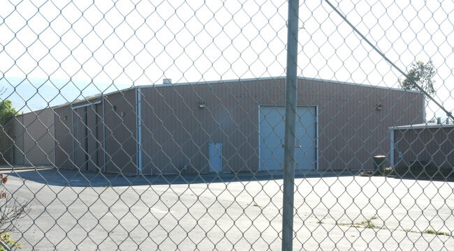
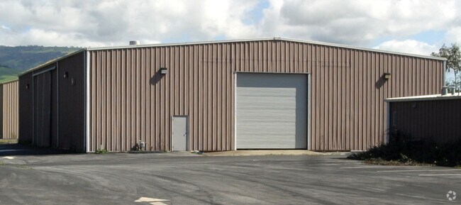
Property Record
13920 Llagas Ave, San Martin, CA 95046

NEARBY LISTINGS FOR SALE OR LEASE
Property Detail
13920 Llagas Ave
825-09-034
San Martin Ranch Map 02
Industrialgeneral
Santa Clara
AE
California
06085C0626H
37
2024
4.21 AC
2025
Morgan Hill
512402
South Bay/San Jose
2,304 SF
San Jose-Sunnyvale-Santa Clara, CA
DEMOGRAPHICS near 13920 Llagas Ave
1 Mile
3 Mile
5 Mile
2024 Total Population
1,776
22,466
65,479
2029 Population
1,620
21,324
62,434
Pop Growth 2024-2029
(8.78%)
(5.08%)
(4.65%)
Average Age
43
42
41
2024 Total Households
516
7,378
20,621
HH Growth 2024-2029
(9.30%)
(5.29%)
(4.89%)
Median Household Inc
$120,555
$135,632
$143,250
Avg Household Size
3.10
2.90
3.10
2024 Avg HH Vehicles
3.00
2.00
3.00
Median Home Value
$1,095,136
$1,063,886
$1,026,330
Median Year Built
1974
1982
1986
Nearby Places
Map Layers
Map Styles
 Street
 Aerial
- Restaurants
- Banks
- Shops
- Fitness
- Groceries
PUBLIC TRANSPORTATION
TRANSIT/SUBWAY
San Martin (Caltrain - Caltrain (Caltrain))
DRIVE
WALK
Distance
San Martin (Caltrain - Caltrain (Caltrain))
3 min
20 min
0.9 mi
COMMUTER RAIL
DRIVE
WALK
Distance
3 min
19 min
0.8 mi
San Martin (Caltrain - Caltrain (Caltrain))
DRIVE
WALK
Distance
San Martin (Caltrain - Caltrain (Caltrain))
3 min
17 min
0.9 mi
AIRPORT
Norman Y Mineta San Jose International
DRIVE
WALK
Distance
Norman Y Mineta San Jose International
39 min
30.3 mi
Nearby Properties
Address
Land Use
TOTAL SIZE
Lot Size
Zoning
Address
Land Use
TOTAL SIZE
Lot Size
Zoning
223,897 SF
8.25 AC
A-20A
Address
Land Use
TOTAL SIZE
Lot Size
Zoning
133,738 SF
5.66 AC
APD
Address
Land Use
TOTAL SIZE
Lot Size
Zoning
6,748 SF
26.12 AC
PUD
Address
Land Use
TOTAL SIZE
Lot Size
Zoning
23.56 AC
R1
Address
Land Use
TOTAL SIZE
Lot Size
Zoning
91,712 SF
4.03 AC
R3
Address
Land Use
TOTAL SIZE
Lot Size
Zoning
60,890 SF
1.73 AC
R3
Address
Land Use
TOTAL SIZE
Lot Size
Zoning
137,553 SF
8.09 AC
R3
Address
Land Use
TOTAL SIZE
Lot Size
Zoning
44,909 SF
0.50 AC
PUD
Address
Land Use
TOTAL SIZE
Lot Size
Zoning
100 SF
11.86 AC
PUD
Address
Land Use
TOTAL SIZE
Lot Size
Zoning
400 SF
3.67 AC
ML
Address
Land Use
TOTAL SIZE
Lot Size
Zoning
60,679 SF
4.52 AC
CG
Address
Land Use
TOTAL SIZE
Lot Size
Zoning
20,140.41 AC
SJ
Address
Land Use
TOTAL SIZE
Lot Size
Zoning
98,151 SF
4.55 AC
M
Address
Land Use
TOTAL SIZE
Lot Size
Zoning
74,982 SF
4.79 AC
R3
Address
Land Use
TOTAL SIZE
Lot Size
Zoning
53,997 SF
4.98 AC
C1
Address
Land Use
TOTAL SIZE
Lot Size
Zoning
47,098 SF
2.30 AC
R3
Address
Land Use
TOTAL SIZE
Lot Size
Zoning
3.98 AC
APD
Address
Land Use
TOTAL SIZE
Lot Size
Zoning
39,166 SF
15.10 AC
HS
Address
Land Use
TOTAL SIZE
Lot Size
Zoning
69,615 SF
2.93 AC
MH
Address
Land Use
TOTAL SIZE
Lot Size
Zoning
50,086 SF
2.02 AC
HC
Address
Land Use
TOTAL SIZE
Lot Size
Zoning
61,733 SF
3.23 AC
CG
Address
Land Use
TOTAL SIZE
Lot Size
Zoning
51,060 SF
4.12 AC
R3
Address
Land Use
TOTAL SIZE
Lot Size
Zoning
5.60 AC
CG
Address
Land Use
TOTAL SIZE
Lot Size
Zoning
59,190 SF
4.01 AC
R3
Address
Land Use
TOTAL SIZE
Lot Size
Zoning
62,470 SF
4 AC
MH
Address
Land Use
TOTAL SIZE
Lot Size
Zoning
58,472 SF
3.65 AC
R3
Address
Land Use
TOTAL SIZE
Lot Size
Zoning
1.88 AC
MU-F
Address
Land Use
TOTAL SIZE
Lot Size
Zoning
63,518 SF
2.35 AC
CT
Address
Land Use
TOTAL SIZE
Lot Size
Zoning
604 SF
9.25 AC
C1
The World's #1 Commercial Real Estate Marketplace
Connect with us
© 2025 CoStar Group
The information above has been obtained from sources believed reliable. While we do not doubt its accuracy we have not verified it and make no guarantee, warranty or representation about it. It is your responsibility to independently confirm its accuracy and completeness. Any projections, opinions, assumptions, or estimates used are for example only and do not represent the current or future performance of the property. The value of this transaction to you depends on tax and other factors which should be evaluated by your tax, financial, and legal advisors. You and your advisors should conduct a careful, independent investigation of the property to determine to your satisfaction the suitability of the property for your needs.