Property Record
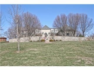
13920 Parallel Rd, Basehor, KS 66007

Property Detail
13920 Parallel Rd
157-36-0-00-00-014.00-0
S36, T10, R22E, ACRES 79.06, PT SE1/4; BEG 30N & 80W SE COR N1317.43, NLY1148.5, W667.2, S1900(S), E2583 TO POB & ABAN RR ROW ADJ (SCALED)
Agriculturalland
Leavenworth
AE The base floodplain where base flood elevations are provided. AE Zones are now used on new format FIRMs instead of A1-A30 Zones.
Kansas
2024
79.06 AC
2025
Leavenworth County
071204
Kansas City
12,661 SF
Kansas City, MO-KS
NEARBY LISTINGS FOR SALE OR LEASE
DEMOGRAPHICS near 13920 Parallel Rd
1 mile
3 mile
5 mile
2025 Total Population
218
13,467
32,047
2030 Population
223
13,913
32,846
Pop Growth 2025-2030
+ 2.29%
+ 3.31%
+ 2.49%
Average Age
41
40
40
2025 Total Households
83
5,095
12,055
HH Growth 2025-2030
+ 2.41%
+ 3.32%
+ 2.55%
Median Household Inc
$94,317
$99,719
$105,630
Avg Household Size
2.60
2.60
2.60
2025 Avg HH Vehicles
2.00
2.00
2.00
Median Home Value
$293,332
$326,476
$334,664
Median Year Built
1998
2002
1999
Nearby Places
Map Layers
Map Styles
 Street
 Aerial
Transit
 Traffic
 Biking
Places
Listings with unknown addresses are not visible on the map
- Restaurants
- Banks
- Shops
- Fitness
- Groceries
PUBLIC TRANSPORTATION
AIRPORT
Kansas City International
Drive
Walk
Distance
Kansas City International
34 min
26.8 mi
Freight Ports
Tulsa Port Of Catoosa
Drive
Walk
Distance
Tulsa Port Of Catoosa
275 min
245.2 mi
Nearby Properties
Address
Land Use
TOTAL SIZE
Lot Size
Zoning
Address
Land Use
TOTAL SIZE
Lot Size
Zoning
920,306 SF
90.21 AC
Address
Land Use
TOTAL SIZE
Lot Size
Zoning
139,516 SF
73.61 AC
Address
Land Use
TOTAL SIZE
Lot Size
Zoning
169,410 SF
37.81 AC
Address
Land Use
TOTAL SIZE
Lot Size
Zoning
77,925 SF
11.31 AC
Address
Land Use
TOTAL SIZE
Lot Size
Zoning
118,146 SF
19.85 AC
WR1B
Address
Land Use
TOTAL SIZE
Lot Size
Zoning
52,047 SF
12.18 AC
Address
Land Use
TOTAL SIZE
Lot Size
Zoning
58,897 SF
141.52 AC
BA1
Address
Land Use
TOTAL SIZE
Lot Size
Zoning
86,176 SF
49.23 AC
KAG
Address
Land Use
TOTAL SIZE
Lot Size
Zoning
141,032 SF
68.59 AC
A1
Address
Land Use
TOTAL SIZE
Lot Size
Zoning
390,400 SF
59.71 AC
Address
Land Use
TOTAL SIZE
Lot Size
Zoning
69,406 SF
29.75 AC
Address
Land Use
TOTAL SIZE
Lot Size
Zoning
26,738 SF
82.01 AC
Address
Land Use
TOTAL SIZE
Lot Size
Zoning
21,511 SF
5.23 AC
Address
Land Use
TOTAL SIZE
Lot Size
Zoning
24,933 SF
17.16 AC
KAG
Address
Land Use
TOTAL SIZE
Lot Size
Zoning
27,279 SF
17.93 AC
Address
Land Use
TOTAL SIZE
Lot Size
Zoning
39,215 SF
18.35 AC
Address
Land Use
TOTAL SIZE
Lot Size
Zoning
48,590 SF
4.72 AC
Address
Land Use
TOTAL SIZE
Lot Size
Zoning
27,568 SF
6.57 AC
WR1
Address
Land Use
TOTAL SIZE
Lot Size
Zoning
29,323 SF
250.53 AC
BA1
Address
Land Use
TOTAL SIZE
Lot Size
Zoning
2.75 AC
Address
Land Use
TOTAL SIZE
Lot Size
Zoning
3,340 SF
119.11 AC
BR
Address
Land Use
TOTAL SIZE
Lot Size
Zoning
26,798 SF
9.65 AC
Address
Land Use
TOTAL SIZE
Lot Size
Zoning
19,753 SF
4.83 AC
Address
Land Use
TOTAL SIZE
Lot Size
Zoning
16,854 SF
2.60 AC
Address
Land Use
TOTAL SIZE
Lot Size
Zoning
14,834 SF
9.99 AC
Address
Land Use
TOTAL SIZE
Lot Size
Zoning
10,320 SF
38.08 AC
Address
Land Use
TOTAL SIZE
Lot Size
Zoning
12,163 SF
3.31 AC
Address
Land Use
TOTAL SIZE
Lot Size
Zoning
100,351 SF
13.11 AC
Address
Land Use
TOTAL SIZE
Lot Size
Zoning
17,558 SF
2.61 AC
BR2
Address
Land Use
TOTAL SIZE
Lot Size
Zoning
9,100 SF
0.64 AC
The World's #1 Commercial Real Estate Marketplace
Connect with us
© 2026 CoStar Group
The information above has been obtained from sources believed reliable. While we do not doubt its accuracy we have not verified it and make no guarantee, warranty or representation about it. It is your responsibility to independently confirm its accuracy and completeness. Any projections, opinions, assumptions, or estimates used are for example only and do not represent the current or future performance of the property. The value of this transaction to you depends on tax and other factors which should be evaluated by your tax, financial, and legal advisors. You and your advisors should conduct a careful, independent investigation of the property to determine to your satisfaction the suitability of the property for your needs.