Property Record
13920 Sw 47Th St, Miami, FL 33175


NEARBY LISTINGS FOR SALE OR LEASE
Property Detail
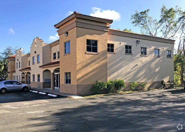
13920 Sw 47Th St
30-4922-045-0030
Bent Tree Commercial Park
Officebuilding
BENT TREE COMMERCIAL PARK I CONDO UNIT A-103 UNDIV 2585/28540 INT IN COMMON ELEMENTS OFF REC 18761-3733/18956-2561 OR 18812-2506 0899 2 COC 22232-3257 04 2004 2
AH
Miami/Dade
12086C0431L
Florida
2024
Kendall
2025
South Florida
016000
Miami-Miami Beach-Kendall, FL
2,585 SF
DEMOGRAPHICS near 13920 Sw 47Th St
1 Mile
3 Mile
5 Mile
2024 Total Population
21,339
189,690
390,666
2029 Population
20,592
183,625
378,368
Pop Growth 2024-2029
(3.50%)
(3.20%)
(3.15%)
Average Age
45
43
43
2024 Total Households
6,757
60,581
126,504
HH Growth 2024-2029
(3.97%)
(3.60%)
(3.59%)
Median Household Inc
$72,147
$69,588
$69,752
Avg Household Size
3.10
3.00
3.00
2024 Avg HH Vehicles
2.00
2.00
2.00
Median Home Value
$380,526
$375,341
$376,707
Median Year Built
1982
1985
1983
Nearby Places
Map Layers
Map Styles
 Street
 Aerial
- Restaurants
- Banks
- Shops
- Fitness
- Groceries
PUBLIC TRANSPORTATION
COMMUTER RAIL
Dadeland North (Metrorail Green Line - Miami-Dade Transit (Metrorail/Metromover))
DRIVE
WALK
Distance
Dadeland North (Metrorail Green Line - Miami-Dade Transit (Metrorail/Metromover))
18 min
9.4 mi
Dadeland South (Metrorail Green Line - Miami-Dade Transit (Metrorail/Metromover))
DRIVE
WALK
Distance
Dadeland South (Metrorail Green Line - Miami-Dade Transit (Metrorail/Metromover))
18 min
9.6 mi
AIRPORT
Miami International
DRIVE
WALK
Distance
Miami International
26 min
13.5 mi
Fort Lauderdale/Hollywood International
DRIVE
WALK
Distance
Fort Lauderdale/Hollywood International
50 min
37.9 mi
Freight Ports
Port of Miami
DRIVE
WALK
Distance
Port of Miami
34 min
20.7 mi
SALE & LEASE HISTORY
LISTING DATE
SALE/LEASE

Nov 10, 2016
For Lease
Nov 09, 2016
For Lease
Aug 14, 2024
For Lease
Nearby Properties
Address
Land Use
TOTAL SIZE
Lot Size
Zoning
Address
Land Use
TOTAL SIZE
Lot Size
Zoning
1,275,460 SF
15.30 AC
6400
Address
Land Use
TOTAL SIZE
Lot Size
Zoning
357,809 SF
9.39 AC
0103
Address
Land Use
TOTAL SIZE
Lot Size
Zoning
404,425 SF
43.03 AC
9000
Address
Land Use
TOTAL SIZE
Lot Size
Zoning
407,900 SF
18.79 AC
3900
Address
Land Use
TOTAL SIZE
Lot Size
Zoning
299,209 SF
15.83 AC
3800
Address
Land Use
TOTAL SIZE
Lot Size
Zoning
349,295 SF
25.16 AC
6061
Address
Land Use
TOTAL SIZE
Lot Size
Zoning
160,000 SF
16.41 AC
8900
Address
Land Use
TOTAL SIZE
Lot Size
Zoning
318,986 SF
20.95 AC
3800
Address
Land Use
TOTAL SIZE
Lot Size
Zoning
391,847 SF
25.68 AC
6400
Address
Land Use
TOTAL SIZE
Lot Size
Zoning
251,244 SF
22.89 AC
6400
Address
Land Use
TOTAL SIZE
Lot Size
Zoning
484,900 SF
152.93 AC
8900
Address
Land Use
TOTAL SIZE
Lot Size
Zoning
19,382 SF
130 AC
8900
Address
Land Use
TOTAL SIZE
Lot Size
Zoning
175,184 SF
12.41 AC
6200
Address
Land Use
TOTAL SIZE
Lot Size
Zoning
412,188 SF
13.87 AC
3900
Address
Land Use
TOTAL SIZE
Lot Size
Zoning
188,499 SF
13.67 AC
6400
Address
Land Use
TOTAL SIZE
Lot Size
Zoning
281,931 SF
31.78 AC
3800
Address
Land Use
TOTAL SIZE
Lot Size
Zoning
266,482 SF
28 AC
8900
Address
Land Use
TOTAL SIZE
Lot Size
Zoning
191,632 SF
13.97 AC
6200
Address
Land Use
TOTAL SIZE
Lot Size
Zoning
199,308 SF
9.67 AC
3800
Address
Land Use
TOTAL SIZE
Lot Size
Zoning
115,970 SF
9.40 AC
3800
Address
Land Use
TOTAL SIZE
Lot Size
Zoning
247,695 SF
8.53 AC
2300
Address
Land Use
TOTAL SIZE
Lot Size
Zoning
111,897 SF
8.32 AC
6200
Address
Land Use
TOTAL SIZE
Lot Size
Zoning
138,945 SF
8.68 AC
6200
Address
Land Use
TOTAL SIZE
Lot Size
Zoning
187,948 SF
11.60 AC
3800
Address
Land Use
TOTAL SIZE
Lot Size
Zoning
110,154 SF
8.99 AC
6062
Address
Land Use
TOTAL SIZE
Lot Size
Zoning
112,552 SF
12.89 AC
6400
Address
Land Use
TOTAL SIZE
Lot Size
Zoning
147,939 SF
9.85 AC
2800
Address
Land Use
TOTAL SIZE
Lot Size
Zoning
103,832 SF
8.15 AC
6200
Address
Land Use
TOTAL SIZE
Lot Size
Zoning
140,102 SF
11.93 AC
6200
Address
Land Use
TOTAL SIZE
Lot Size
Zoning
120,626 SF
11.82 AC
6200
The World's #1 Commercial Real Estate Marketplace
Connect with us
© 2025 CoStar Group
The information above has been obtained from sources believed reliable. While we do not doubt its accuracy we have not verified it and make no guarantee, warranty or representation about it. It is your responsibility to independently confirm its accuracy and completeness. Any projections, opinions, assumptions, or estimates used are for example only and do not represent the current or future performance of the property. The value of this transaction to you depends on tax and other factors which should be evaluated by your tax, financial, and legal advisors. You and your advisors should conduct a careful, independent investigation of the property to determine to your satisfaction the suitability of the property for your needs.